Geography and size of arable land in Taiwan is one important point to be focus when planning for the AR.
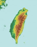
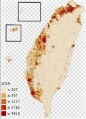
Taiwan is a potato shape island about 380KM long and 140KM at widest point and about 1,000Km of shoreline, with arable land and plain mainly on the West coasts and rugged mountains in central and East. The West coast plains have maximum width of about 45 to 50km, and majorirty of Taiwan's population are staying here. This is also where Taiwan's crops and industries are located.
Thus the main PLA objective would be to take over the West coast plain, and pockets of flat lands in the East, i.e. Yilan, Hualien, Taitung and Checheng/Hengchun. The rugged moutains are sparesely inhabitated, lack crop and industrial resources and thus can be left for second phase of mopping up whatever left of RoC that are still fighting.
Blockading 1,000km of Taiwan island shoreline with hundreds of surface combat ships and submarines, and hundreds of CAP fighter jets should seal the island water-tight, the only probable infiltration into the island would be small units of SEAL team but they are too small numerically to re-supply the RoC troops nor alter battle situations, except to smuggle out the leadership of Taiwan pro-independence.
PLA could either blockade the island and starve them to internal revolt and surrender, or bloakade and attack on Day One on all fronts to take over the plains, and mop up the mountains at later phase of war.
Topography of Taiwain, shows plains and mountains.

Population density and distribution

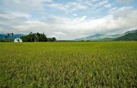
West coast plains of Taiwan

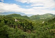
The rugged mountains in central and east of Taiwan.


