Ladakh Flash Point

Status
Not open for further replies.

Xizor

Captain
Registered Member
But, Raj47 is unreliable. He is fake news.

Also this ( I posted week ago) -

Then there is this article on November, 2020 (winter) -

In the Galwan Valley too, the LAC “was effectively shifted by a kilometre (km) into India”. “The terms of disengagement, negotiated on June 30 between senior military commanders from both sides, regard the LAC as running through the so-called Y-Nallah Junction. This is one km inside India when compared with the LAC’s historical alignment next to Patrolling Point 14 (PP-14). The area in which PP-14 is located—and which the Indian Army has patrolled for decades—now effectively falls inside China’s buffer zone.”

Please, Log in or Register to view URLs content!

This newspaper is unreliable too.
But the wiki entry of
Please, Log in or Register to view URLs content!
says that it is a "
Please, Log in or Register to view URLs content!
". So that means among all the unreliable news this might be the lead unreliable (for Indians).

PS : Can't trust them for foreigners pov though as National Interest overrules all. WSJ, WP has that label too.
 

Abominable

Major
Registered Member
I thought that it was just the Indian media and Indian internet warriors who were delusional. I imagined the Indian army were embarrassed about being caught with their pants down and were working behind the scenes to address their massive deficiencies.

Wrong!

Even the generals are deluded, they're posting youtube Q&As with titles like:
China's Defeat and Impact on Afghanistan and Pakistan


Indians really are a special bunch.
 

davidau

Senior Member
Registered Member
I thought that it was just the Indian media and Indian internet warriors who were delusional. I imagined the Indian army were embarrassed about being caught with their pants down and were working behind the scenes to address their massive deficiencies.

Wrong!

Even the generals are deluded, they're posting youtube Q&As with titles like:
China's Defeat and Impact on Afghanistan and Pakistan


Indians really are a special bunch.
Please explain?
 

Xizor

Captain
Registered Member
One of the most important pieces of Information that has been needling my mind.

Where exactly is the PP14?

We know that most discussions have been conducted ( regarding Galwan Valley) assuming PP14 as the point of conflict.

This is the point that is often cited as PP14 (in Indian media).
Galwan.jpg


But this is likely Misleading.

The original post that forced me to think different and question was this person's analysis.
Ajai skukla (retd) Indian soldier ( whose take is disliked by certain political and ideological class in India)
1594233370-5298.jpg

Above depicts his presentation on the disengagement map along with the shift in LAC he claims happened with it.

He goes to explain that -
The terms of disengagement, negotiated on June 30, regard the LAC as running through the so-called Y-Nallah Junction.
This is 1 km inside India, when compared with the LAC’s historical alignment next to Patrolling Point 14 (PP-14).

The area in which PP-14 is located – and which the
Please, Log in or Register to view URLs content!
has patrolled for decades – now effectively falls inside China’s “buffer zone”.


Army sources point out that by measuring all distances from the Y-Junction, rather than from the traditional LAC alignment west of PP-14, the Y-Junction has been effectively regarded as the LAC point.
It is learnt that this was done on the insistence of Chinese military negotiators. New Delhi continues to insist that the LAC runs along the line of PP-14, but has undermined its own claim by agreeing to locate its forward tent post 2.4 km from what it claims is the LAC, while allowing the Chinese forward tent post to be just 400 metres from our claimed LAC


So, I was a bit confused. Isn't this region (posted below /closer) the PP14?
china_660_250620094547.jpg

But seems like that isn't the case ( apparently).
Further digging led me to this website.
Please, Log in or Register to view URLs content!


This soldier is a retired one who had, in the past 1970s done patrols for India to these regions. He corroborated the claim of the soldier above.


“I have been there … I am very clear about that.”

Brig Dhillon has led a foot patrol in the Galwan valley, when he was a captain with Ladakh Scouts, in 1979
, “Yes, our patrolling point lies well inside the LAC, by over one kilometre, perhaps two. According to Brig Dhillon, the actual LAC alignment in the recent conflict zone is as shown in the map below


ca1deafc0ff8c7bf3ecaee2e49d67f99db1f3245.jpg

According to Brig Dhillon, it is another 5-plus kilometres from the recent clash zone to where the Chinese road ends and new road construction was seen on their side. This means that smooth movement of the PLA’s equipment and wheeled vehicles is possible till very close to the original LAC.

This seems true. Chinese road construction doesn't go all the way to the PP14 (that Indian media is showing its citizens).

Continued...
 
Last edited:

Xizor

Captain
Registered Member
So ultimately, that means, Ajai Shukla is right, (or has multiple other sources to back him up).
1594233370-5298.jpg

And therefore the above representation isn't a lie (likely).

So this representation below (by the retired Ladakh Patrol leader) is likely to be the truth that existed during the incident of infamy -
6b4bae8e4e6a730791da09a2da4a2edbaad4dd0e.jpg
And that has made China shift the LAC into Y junction and made claims beyond.

The Indian article also raises other questions -

1.

Have sundry “analysts” of commercial satellite images consciously lied to us about where the LAC lies and the Chinese presence “inside” our territory?

2.

Have we been told the truth by the “sources” claiming to be close to the authorities on this subject or has a deliberate and concerted attempt been made to mislead the Indian public?

The below picture gives a clearer idea about all this -
604a94b4458a5437057320af65d0654e09a13efd.png

Has the Indian media potrayed Y junction as PP14?
Then that can change how we view the entire happening past year. The script changes drastically.
 
Last edited:

Xizor

Captain
Registered Member
One extra piece of information

The article I cited before mentioned that China has a road that doesn't extend to the pseudo-PP14.
galwan_505_170620040107.jpg

Do note that here the flash point is mentioned as "PP14" which is likely Y junction and not the original.The point is the Chinese road that doesn't extend to the new PP14 but close to only the old PP14. (Assuming the retired soldiers are right! ).
 

twineedle

Junior Member
Registered Member
This is what actual experts are saying, not bloggers like Shukla and sawnhey.

Please, Log in or Register to view URLs content!


Please, Log in or Register to view URLs content!


A small excerpt.

"Why did China agree?
The disengagement occurred because China appeared to alter its
Please, Log in or Register to view URLs content!
. Previously, China had demanded that India first withdraw from its new positions on the Kailash Range before China would move from the northern bank of Pangong Lake. The deadlock
Please, Log in or Register to view URLs content!
in late November, when China agreed to pull back to a position known as Finger 8, satisfying an Indian demand, but was not finalized until late January. Why did China change its position?"


And it looks like the narrative here has changed again. Apparently, google(which bass lines on official claims and documents) is wrong, so are almost all respeced defence analysts, and Ajai Shukla is right. Also interesting to see that particular retired officer is taken completely seriously, but Col. S. Dinny, who had RECENTLY served on Pangong Tso is supposedly a bhakt becasue he said Indian troops had never patrolled past finger 3. Brig. RJS does not even say the that pp14 is past the bend, just that the lac is east of that point, which is true. I am especially interested in how Indian soldiers regularly patrolled across the river without a bridge, or why the Indian government supposedly claimed up to exact point Ajai Shukla is claiming(even though no GOI documents support that. Also interesting taht despite that point suppowedly being the lac, there are no roads or foot paths connecting it to the IIndian side. But I guess Chinese members here have to claim victory somehow. Ironically that Ajai Shukla article contradicts China's claims
that India violated the Lac.

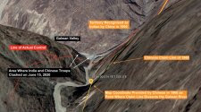
This shows the buffer zone pretty well. Keep in mind India never disputed the LAC. at Galwan. PP14 is definitely located west of the LAC, meaning that CHina did temporarily violate it, though it is definitely not as far east as Shukla insists it is

And this is what the wire, the same outlet Pravin Sawhney writes for, shows as the LAC

Shiv Aroor, one of the most accurate journalists covering the conflict, also shows the bend as pp14, and uses the same lac as Google and the wire

So obviously, there must be some confusion


1615092836344.png
 

Attachments

  • Galwan-LatLong-copy.jpg
    Galwan-LatLong-copy.jpg
    225.2 KB · Views: 6
Last edited:
Status
Not open for further replies.
Top