Ladakh Flash Point

Status
Not open for further replies.

twineedle

Junior Member
Registered Member
Google Marks Gogra. When you search for Gogra in Google, it sets the coordinates to a point some distance away from the Gogra Post.
That is east of PP17 A. But Hot springs is not marked.

What you are saying is that Hot Springs have all along been Gogra ( which is not and is a false information).

There has been an error on my part in assigning PP15, PP16 etc. In fact often, I placed PP15 in the confluence region of Changlung-Kugrang. I was of the impression that confrontation above the PP17A Gogra Post was limited to one place.
-Hot springs confrontation was signified all along as the Camps India and China had close proximity. There was much back and forth in this thread on that basis too. Having clear PP15/16 seemed unnecessary in that case.

But what you seem to be posing is that China had posts further above confluence of kugrang-changlung. Which means there are more regions of confrontation ( other than the 4) between the Galwan and Chang Chenmo.


No, one is arguing with Sharma. I don't understand why you bring up him. His statements only lend credence to the " China occupies Indian land after 2013" claim. I think it's pretty clear. I've already explained how China, if completely taking up the Burtse would've satisfied its claims and make any maneuvering further, difficult.
By now you should know that the patrol points go in ascending order from Karakorum pass all the way down to Chumar. The point I posted as pp15 is much closer to Galwan, which contains pp14, than the Kugrang Changlung confluence, which is where points 17- 17a. The Hot Springs post(marked Gogra) is near the Kongka La sector(that big bulge next to the Hot Springs Post marked as Gogra). That is where pps 18-19 are, however, there is no evidence of any standoff point there , just heavy buildup on Chinese side. I have already shown this with multiple satellite images.

Partial disengagement already occurred last July, most of the PLA forward posts along the LAC were withdrawn or "recalibrated," the only one that remained was that platoon sized camp near Gogra, with a mirror deployment by India at pp17a.
 

jfy1155

Junior Member
Registered Member
By now you should know that the patrol points go in ascending order from Karakorum pass all the way down to Chumar. The point I posted as pp15 is much closer to Galwan, which contains pp14, than the Kugrang Changlung confluence, which is where points 17- 17a. The Hot Springs post(marked Gogra) is near the Kongka La sector(that big bulge next to the Hot Springs Post marked as Gogra). That is where pps 18-19 are, however, there is no evidence of any standoff point there , just heavy buildup on Chinese side. I have already shown this with multiple satellite images. Partial disengagement already occurred last July, most of the PLA forward posts along the LAC were withdrawn or "recalibrated," the only one that remained was that platoon sized camp near Gogra, with a mirror deployment by India at pp17a.

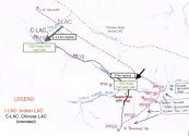
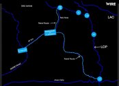
What is your username in DFI?
 

twineedle

Junior Member
Registered Member
Not unbiased. Or Clear.
Stop the shitposting, Jai Hind.

Galwan

We have gone over that map nigh times. It's is for the events before 1962. It is also not to scale.
Further -
Please, Log in or Register to view URLs content!


Also
View attachment 72459

Depsang

For Depsang, China's current claim limit and India's LAC are two distinct things. China has expanded its Depsang area and has seized and consolidated 80% of the land ( till Burtse)
View attachment 72460
So indeed it's mutually blocking. But I'd say India losing land since 2013. With China gaining lot more land.

It takes special talent to twist this new reality as being "China denied land (forget huge piece).

More like India losing huge piece. China has only gained.


Hot Springs

Kugrang river relates to Hot Springs. Not Gogra specifically (if you are being faithful with the discussion over the past few months in this thread.)

In Hot Springs, China has camps 1 km + into Indian LAC. But heavy snowfall has resulted in long term deployment untenable. The article you cited itself says that. It also notes that China has built up significantly behind the Indian LAC though. The India Today article specifies these things. It also notes that no change has happened to other regions.


But that's not the important point. The important question are to which location exactly is the map pointing at?

The maps in India Today does not point to the changlung - kugrang River confluence. Both the maps used (1 gif and 1 map which I cited below) also have winding roads nearby ( a feature near Chinese posts above the LAC).

All these point to the reality that these maps are for the Chinese posts within what is beyond India's LAC. There is a Hot Springs there.

View attachment 72463
View attachment 72464
Your own map shows the area between the bottleneck and Burtse + Track Junction(not shown, close to DBO) is about the same as the area within India's LOP. That is exactly what Lt. Gen. Sharma said
 

Xizor

Captain
Registered Member
By now you should know that the patrol points go in ascending order from Karakorum pass all the way down to Chumar. The point I posted as pp15 is much closer to Galwan, which contains pp14, than the Kugrang Changlung confluence, which is where points 17- 17a. The Hot Springs post(marked Gogra) is near the Kongka La sector(that big bulge next to the Hot Springs Post marked as Gogra). That is where pps 18-19 are, however, there is no evidence of any standoff point there , just heavy buildup on Chinese side. I have already shown this with multiple satellite images.

Partial disengagement already occurred last July, most of the PLA forward posts along the LAC were withdrawn or "recalibrated," the only one that remained was that platoon sized camp near Gogra, with a mirror deployment by India at pp17a.
About the maps -
So that means there are more points of confrontation. More than Four. And the India Today News is referring to these points.

" Hot Springs" when you are talking mean an entire stretch of land to the west of Kungrang Changlung.

The Kungrang changlung part is also Hot Springs. You only reinforced Ajai Shukla maps here. But in the past only a single confrontation ( the posts where Kungrang Changlung meets) have been recorded as Hot springs.

And as per retired soldiers, China still nibbles at the PP19 posts. Gogra therefore, naturally, remains a problem for India.
Current status -

PLA does not have forward posts Along the LAC of India but within the LAC of India. The Indian government therefore brings this up. India could do a "mirror deployment" if the former was the case.

Whatever be the Hot Springs PP point statuses or demarcation be, The article itself states that China has "recalibrated" the forward posts. With heavy buildup in Camps within China's traditional region, it's due to the snow and harsh weather that China can't operate these forward posts to the full capacity.
 

twineedle

Junior Member
Registered Member
About the maps -
So that means there are more points of confrontation. More than Four. And the India Today News is referring to these points.

" Hot Springs" when you are talking mean an entire stretch of land to the west of Kungrang Changlung.

The Kungrang changlung part is also Hot Springs. You only reinforced Ajai Shukla maps here. But in the past only a single confrontation ( the posts where Kungrang Changlung meets) have been recorded as Hot springs.

And as per retired soldiers, China still nibbles at the PP19 posts. Gogra therefore, naturally, remains a problem for India.
Current status -

PLA does not have forward posts Along the LAC of India but within the LAC of India. The Indian government therefore brings this up. India could do a "mirror deployment" if the former was the case.

Whatever be the Hot Springs PP point statuses or demarcation be, The article itself states that China has "recalibrated" the forward posts. With heavy buildup in Camps within China's traditional region, it's due to the snow and harsh weather that China can't operate these forward posts to the full capacity.
Please show some clear evidence of those posts "within the LAC."(which remains the same as it was at Gogra-hot springs and glawan and other secotors, despite China's failed attempts to shift it westwards). I already showed you pp15 and the pla camp that has now been withdrawn

And Gogra is 17-17a. 19 is Kongka La. Not even any reputable indian media sources like India today mentioned those points.
 
Last edited:

Xizor

Captain
Registered Member
That is where pps 18-19 are, however, there is no evidence of any standoff point there , just heavy buildup on Chinese side. I have already shown this with multiple satellite images.

Well, you haven't. Can you redraw the maps with all the patrol points as this -
Meera Ajai mp.jpg

Indian insistence of an issue / resolution of it, in the Gogra sector( as per you a part of Hot Springs general region) means that there isn't just a mere buildup. India could always reply that buildup with a mirror deployment.

But rather, it complains in its official announcements / releases.

Depsang -

Whatever you do, don't try to say that " China failed to reach Burtse and therefore it is a stalemate". Stop it. It's very embarrassing.

China now occupies till the Bottleneck ( since 2013). That means China has never went back once but kept on pushing. Remember that somewhere near Burtse is China's Claim line and somewhere beyond Bottleneck is India's LAC (perceived).

Too many back and forth on Claim vs LAC, I'm pretty sure almost all other members would've realised it. To insist that both lost is a bit of a cope mechanism in this case.

China reaching Burtse would mean two things
1. China can't maneuver further there
2. China satisfied its claims.

Its all China's willing being played out in that region ( Depsang). India taking the initiative to do things in the region between Burtse and Y junction...would mean something. But that has not happened.
Screenshot_20210524-052135.jpg
 

Xizor

Captain
Registered Member
Please show some clear evidence of those posts "within the LAC." I already showed you pp15 and the pla camp that has now been withdrawn

And Gogra is 17-17a. 19 is Kongka La. Not even any reputable indian media sources like India today mentioned those points.
"Recaliberated" as per Indian news itself. It is you who claims that this happens in PP15 ( Maybe you can post a map showing all the posts in this region that lies west of Changlung Kungrang. Also. Don't use Google map tagging,its not productive. Try to create one.)

Please, Log in or Register to view URLs content!


I think this is the article you are referring to?
No mention of patrol points in that. Merely says that China had to recalibrate because of the high snowfall and terrain. No mention of "pullback" or " retreat".
 

twineedle

Junior Member
Registered Member
Well, you haven't. Can you redraw the maps with all the patrol points as this -
View attachment 72499

Indian insistence of an issue / resolution of it, in the Gogra sector( as per you a part of Hot Springs general region) means that there isn't just a mere buildup. India could always reply that buildup with a mirror deployment.

But rather, it complains in its official announcements / releases.

Depsang -

Whatever you do, don't try to say that " China failed to reach Burtse and therefore it is a stalemate". Stop it. It's very embarrassing.

China now occupies till the Bottleneck ( since 2013). That means China has never went back once but kept on pushing. Remember that somewhere near Burtse is China's Claim line and somewhere beyond Bottleneck is India's LAC (perceived).

Too many back and forth on Claim vs LAC, I'm pretty sure almost all other members would've realised it. To insist that both lost is a bit of a cope mechanism in this case.

China reaching Burtse would mean two things
1. China can't maneuver further there
2. China satisfied its claims.

Its all China's willing being played out in that region ( Depsang). India taking the initiative to do things in the region between Burtse and Y junction...would mean something. But that has not happened.
View attachment 72500
I have already explained that Gogra is around the confluence of Kugrang and Changlung, and there is a pla camp there. That is the problem India is trying to get removed. If there is evidence(not claims) of any other incursions, I would be more than happy to see that. I already showed evidence of one major PLA forward camp within India's LAC near pp15 that was withdrawn, and you can quite clearly see remains of the camp. Same with other PLA camps near the Kugrang Changlung junction that were withdrawn.

And as for the "retired soldiers" bit, many retired soldiers who actually served on the ground there disagree with Shukla.
 
Last edited:

twineedle

Junior Member
Registered Member
Well, you haven't. Can you redraw the maps with all the patrol points as this -
View attachment 72499

Indian insistence of an issue / resolution of it, in the Gogra sector( as per you a part of Hot Springs general region) means that there isn't just a mere buildup. India could always reply that buildup with a mirror deployment.

But rather, it complains in its official announcements / releases.

Depsang -

Whatever you do, don't try to say that " China failed to reach Burtse and therefore it is a stalemate". Stop it. It's very embarrassing.

China now occupies till the Bottleneck ( since 2013). That means China has never went back once but kept on pushing. Remember that somewhere near Burtse is China's Claim line and somewhere beyond Bottleneck is India's LAC (perceived).

Too many back and forth on Claim vs LAC, I'm pretty sure almost all other members would've realised it. To insist that both lost is a bit of a cope mechanism in this case.

China reaching Burtse would mean two things
1. China can't maneuver further there
2. China satisfied its claims.

Its all China's willing being played out in that region ( Depsang). India taking the initiative to do things in the region between Burtse and Y junction...would mean something. But that has not happened.
View attachment 72500
India is already between Burtse and Y Junction. The bottleneck is being blocked from the Indian side. Also, Indian patrols went to the line of patrol, not india's perception of LAC.

You can see for yourself the area between Burtse and South of DBO and the bottleneck. PLA used to patrol that area and even occupied it in 2013. That area is now blocked. PLA is also blocking India from reaching the LOP.
Depsang LA, which seperates teh Depsang plains from Burtse and DSDBO road, is also under Indian control.
 
Status
Not open for further replies.
Top