Ladakh Flash Point

Status
Not open for further replies.

twineedle

Junior Member
Registered Member
It's been almost a year, but this is still the most detailed and accurate assessment of gogra Hot Springs. Som changes have occurred since then, but for the most part this has been corroborated by detresfa's latest imagery.
Please, Log in or Register to view URLs content!
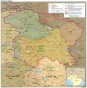
And despite what some want to say, the de facto LAC is clear, even though both sides having differing perceptions at certain areas. It hasn't changed anywhere, whether at Galwan or Hot Springs. This recent CIA map made in 2004 matches the LAC of today., despite China's attempts to shift it west.
 

Attachments

  • kashmir_region_2004.jpg
    kashmir_region_2004.jpg
    397.7 KB · Views: 3
Last edited:

Xizor

Captain
Registered Member
Detresfa's image clearly shows there are PLA forward deployments between China's Kongka La base and the LAC. The second image I posted provides more specific locations for said positions. The LAC is also quite clear in that area.
Please, Log in or Register to view URLs content!

Also, the disputed land is at hot Springs, not Gogra. That's why the red circle is labeled as the conflict point, both sides were deployed slightly east of that, and still are to some extent. The issue east of Gogra is simply due to buildup and forward deployment on both sides that was not there before 2020, hence change in status quo. China uses the same arguement when it objects to India's infrastructure construction.
The reason why points > 17 are not mentioned by any credible Indian media source is becausue there is no confrontation there. Not a single Indian gov. statement mentions those points.
You are trying to draw parallel between two unrelated things.

China, on the Galwan valley clash has said that Indian construction activities in what is a claimed region preceeded the Indian intrusion across LAC to China and lead to the clash.

China doesn't say that construction activities directly caused the clash. China also hasn't demanded India to destroy whatever it built up in what is far within the LAC of India.

You insist, But in Gogra PP17A, India wants China to dismantle its position inside China's control regions.
 

twineedle

Junior Member
Registered Member
China also wants India to withdraw its forward positions from both Gogra and Hot Springs sectors and stop road building there. And before india occupied Rechin and Rezang La, China's condidtion for disengagement was vacating Dhan Singh Thapa(finger 3), which India had for decades.
 

Xizor

Captain
Registered Member
It's been almost a year, but this is still the most detailed and accurate assessment of gogra Hot Springs. Som changes have occurred since then, but for the most part this has been corroborated by detresfa's latest imagery.
Please, Log in or Register to view URLs content!
Good that you quoted this again.
I won't go into the background of Mitra here (because that'd mean going into ad hominem on Ajai Skukla).

1. Detail and LAC
Mitra description is not detailed enough as Ajai Shukla. He doesn't mention Patrol points but points of concern. The one thing he draws is the Indian LAC interpretation.

2. Date

Mitra is outdated regarding Hot Springs PP15. We have seen that Chinese camps do exists far inside the LAC of India recently.

But Ajai Shukla hasn't been wrong regarding China coming inside the LAC. His article was on June 10.


3. A quarter of the article discusses what was the situation in and around Gogra Hot Springs. But the rest is Pangong Tso.
 

ougoah

Brigadier
Registered Member
China also wants India to withdraw its forward positions from both Gogra and Hot Springs sectors and stop road building there. And before india occupied Rechin and Rezang La, China's condidtion for disengagement was vacating Dhan Singh Thapa(finger 3), which India had for decades.

Can you point on google maps where India occupied Rechin and Rezang La and give rough timeframe of when it allegedly did this?

As far as I'm aware, India never "occupied" anything for longer than a week or so that is mutually considered on China's side. India is on Reqin (Rechin) on India's own side. PLA and China never had issue with this. Only some Indian figures kept suggesting that India is somehow losing out on negotiations because it "gave up" south of lake positions it took over.
 

Xizor

Captain
Registered Member
China also wants India to withdraw its forward positions from both Gogra and Hot Springs sectors and stop road building there. And before india occupied Rechin and Rezang La, China's condidtion for disengagement was vacating Dhan Singh Thapa(finger 3), which India had for decades.
Topic : Pangong Tso.

Exactly. And that's when China had all the big cards in the deck. No incentive whatsoever for a breakthrough, is there? We can argue about India pushing into the southern flanks of Kailash but if we were to look at the Chinese opposition elsewhere before and since, it is quite clear that that push wouldn't have materialized if China really didn't want it to.

But then that's just suppositions.


Topic : Gogra Hot Springs.

China has demanded India dismantle its posts in Hot Springs and Gogra? Can you quote it?
 

twineedle

Junior Member
Registered Member
1. Detail and LAC
Mitra description is not detailed enough as Ajai Shukla. He doesn't mention Patrol points but points of concern. The one thing he draws is the Indian LAC interpretation.

2. Date

Mitra is outdated regarding Hot Springs PP15. We have seen that Chinese camps do exists far inside the LAC of India recently.

But Ajai Shukla hasn't been wrong regarding China coming inside the LAC. His article was on June 10.


3. A quarter of the article discusses what was the situation in and around Gogra Hot Springs. But the rest is Pangong Tso.
Yes, there were temporary intrusions later in the summer. As I said some things changed, though most Indian and Chinese positions were removed after temporary disengagement. But Ajai Shukla was incorrect when he said Indian troops were behind pp15. ACcording to his own map, there is one Indian camp and one PLA camp(not camps) several km EAST of pp15, and about 2 km from the lac. That is the major conflict point remaining. Both the PLA and Indian camp are in disputed territory neither side had occupied before. Which means that pp15 is not off limits to Indian troops, when they are clearly east of it.
 
Last edited:

ougoah

Brigadier
Registered Member
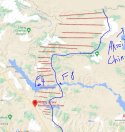
map.jpg


Blue line is where China actually controls up to. Red shaded is the remaining 20% of dispute. 80% of historic dispute was settled already after 1962 but still claimed formally by India. To see the full 100% this map needs to be zoomed out a fair bit.

India captured what exactly where and when??

Fact. India has not been even close to the blue line.

Fact. Both sides have gone into red zone (20% dispute). China says India has patrolled red zone much more (also said by India's own 4 star general) and acted with PLA push from F8 to F4 and occupied it for a whole year. India says China has been building up. Both sides have been building up on their side (not in red zone) and China has built one road from F5 to F8 inside red zone as this confrontation built up.

India has already lost 80%. It wants this red zone (20%). It wants more in fact and wants Aksai Chin. This land is more Chinese than it is Indian. While it's strategically much more important for India, China has a slightly better historic claim.

Black top is slightly more east than Helmet top but that's as deep into the red zone as India is now at south of pangong lake. The further intrusion done back in Oct 2020, was quickly responded to by PLA and the Indians pushed out back to Black top and Helmet top, both well on the left half of the red zone, south of Pangong lake while PLA is beyond half way point at this spot. North of Pangong lake, India is beyond half way line of red zone and PLA is on the eastern half.
 

Xizor

Captain
Registered Member
Yes, there were temporary intrusions later in the summer. As I said some things changed, though most Indian and Chinese positions were removed after temporary disengagement. But Ajai Shukla was incorrect when he said Indian troops were behind pp15. ACcording to his own map, there is one Indian camp and one PLA camp(not camps) several km EAST of pp15. That is the major conflict point remaining. Both the PLA and Indian camp are in disputed territory neither side had occupied before.
PP15

But it still doesn't contradict Ajai Skukla as he says China intruded 2 km into LAC, does it?

While it true that Temporary disengagement may have seen troop pullback, as per India, China is still intruding with the camps in PP15.

True THAT Indian troops are close to China here but that is since then. Things certainly change after Ajai Skuklas article on June 10,

The focus here is on the accuracy of Mitra vs Shukla.
 

Xizor

Captain
Registered Member
View attachment 70974


Blue line is where China actually controls up to. Red shaded is the remaining 20% of dispute. 80% of historic dispute was settled already after 1962 but still claimed formally by India. To see the full 100% this map needs to be zoomed out a fair bit.

India captured what exactly where and when??

Fact. India has not been even close to the blue line.

Fact. Both sides have gone into red zone (20% dispute). China says India has patrolled red zone much more (also said by India's own 4 star general) and acted with PLA push from F8 to F4 and occupied it for a whole year. India says China has been building up.

India has already lost 80%. It wants this red zone (20%). It wants more in fact and wants Aksai Chin. This land is more Chinese than it is Indian. While it's strategically much more important for India, China has a slightly better historic claim.

Black top is slightly more east than Helmet top but that's as deep into the red zone as India is now. The further intrusion done back in Oct 2020, was quickly responded to by PLA and the Indians pushed out back to Black top and Helmet top, both well on the left half of the red zone, south of Pangong lake.
Yes. It is true that China has 80% of what it claims. And India has 20% of what it claims in Ladakh.

I've recently noticed that some Jai Hinds have decided to rename Aksai Chin to Aksai Hind (in DFI)
Maybe it was too obvious to them? It's quite amusing.
 
Status
Not open for further replies.
Top