Ladakh Flash Point

Status
Not open for further replies.

ougoah

Brigadier
Registered Member
The Chinese embassy clearly mentioned "Galwan estuary"
Please, Log in or Register to view URLs content!

As for Depsang
Please, Log in or Register to view URLs content!

For Hot Springs, this map shows the disputed areas China claims. This spot east of pp15(India's historic patrolling limit) is where the standoff in Hot Spring is taking place, and it is the area referred to as a problem by both India and the US.
The yellow bulge is where China claims.

Yes so my udnerstanding of this Gogra HS issue is basically the yellow line drawn on that map you posted.

Here it is as a red dot. As posted I think yesterday.

Aksai_Chin_Sino-Indian_border_map.png

So basically China indeed has forward positions now. Forward of blue line - west of blue line where China controls.
 

twineedle

Junior Member
Registered Member
Indian government and US government have both officially said that Gogra HS are points of contention where PLA has not disengaged... presumably they mean they have not disengaged from forward positions. Presumably forward or west of blue and red line (China's control and LAC respectively).

I don't know anything beyond that.

It doesn't even matter. The situation is PLA has pushed beyond blue line since this standoff. That's it. This simple. They have pushed beyond because China claims India is conducting increasingly hostile and frequent patrols into this disputed stretch that remains (the 20%) that was no mans land but India wants it. This is udnerstandable since China's already got 80% of the total dispute and west of this remaining stretch of no man's land is India proper. India's lost at every single step since 1950.
If there were Chinese positions west of the lac in gogra, wouldn't that clearly be visible to satellite images right now? Yet the most recent images(the ones on IDF) show only Indian posts in the region. I already said the area the US and India referred to is in Hot Springs, not Gogra. There is literally no evidence supporting that claim about Gogra,

At least you aknowledge that the lac is where the dotted line is, not where Shukla says.

And since when does China recognize beyond the dotted line as India proper? In Gogra there is no difference of perception, but in other areas, China claims vast areas beyond the dotted line.
 

ougoah

Brigadier
Registered Member
We've been the ones saying that "disengagement" is just a sell to Jai Hinds. Even that Pangong disengagement basically made a buffer out of no man's land and prevented India from patrolling it. If you want to believe India never patrolled it, well it's okay. The objective of PLA occupation of F4 to F8 was achieved. That's the reason they disengaged clearly. LOL PLA disengaged for some reason correct? That reason was (and it was announced officially by both sides) that India will agree to Chinese conditions of India going behind F3 and no longer stepping foot east of F3.

As for elsewhere, India and US both said officially that disengagement has not happened and clearly wasn't part of Pangong negotiations. Negotiations for disengagement of PLA in Demchok, Gogra HS and wherever else, is still being done. Like I've been saying for a few months may be the case.
 

twineedle

Junior Member
Registered Member
Yes so my udnerstanding of this Gogra HS issue is basically the yellow line drawn on that map you posted.

Here it is as a red dot. As posted I think yesterday.

View attachment 70341

So basically China indeed has forward positions now. Forward of blue line - west of blue line where China controls.
Right. And that is the problem spot. Disengagement there started in July but obviously was not completed. China probably wants India to go back behind pp15, but India is refusing. My guess is because India wants China to remove the new post on its side of the dotted line. Since both sides have not come to an agreement, the standoff continues in that yellow circle. In other areas, it has effectively been resolved.

Meanwhile, the only Chinese position in the gogra sector is the camp nearly 6 km from the LAC(Indian claim line). Anyone who believes otherwise is welcome to provide clear evidence supporting their arguement).
 

ougoah

Brigadier
Registered Member
If there were Chinese positions west of the lac in gogra, wouldn't that clearly be visible to satellite images right now? Yet the most recent images(the ones on IDF) show only Indian posts in the region. I already said the area the US and India referred to is in Hot Springs, not Gogra. There is literally no evidence supporting that claim about Gogra,

At least you aknowledge that the lac is where the dotted line is, not where Shukla says.

And since when does China recognize beyond the dotted line as India proper? In Gogra there is no difference of perception, but in other areas, China claims vast areas beyond the dotted line.

Please share your "most recent" images showing only Indian positions at the red dotted area at Gogra HS.

I don't know what Shukla's been saying can you please not strawman here. That's another member. I am not a part of that conversation.

I'm saying there is so much noise in Indian media and Indian gov and US gov both say PLA are inside India basically. They mean beyond blue line. They treat anything west of blue line (where China controls) as India. This is China's issue with the matter and why it occupied so much of the buffer/no man's land/ remaining 20% of dispute. To reverse this thinking that this is India and to prevent India from occupying and patrolling it. Perhaps why China has not disengaged yet.

They will if India agrees to make a buffer out of this. However this would be a monumental India total loss. Since it would have lost 80% of the total dispute to China while the reaminging 20% becomes a buffer.
 

ougoah

Brigadier
Registered Member
Right. And that is the problem spot. Disengagement there started in July but obviously was not completed. China probably wants India to go back behind pp15, but India is refusing. My guess is because India wants China to remove the new post on its side of the dotted line. Since both sides have not come to an agreement, the standoff continues in that yellow circle. In other areas, it has effectively been resolved.

Meanwhile, the only Chinese position in the gogra sector is the camp nearly 6 km from the LAC(Indian claim line). Anyone who believes otherwise is welcome to provide clear evidence supporting their arguement).

Yes this is what I personally suspect as well. China wants India totally out of the dotted pink to blue line areas encircled/ no man's land/ 20% remaining of total dispute.

India wants to take it since China's already won the 80% of total dispute. I think this is more than understandable for India. But China is exerting its strength here and not playing nice with India BECAUSE India went back on (understandably but still dirty move) past 1990s agreements and Wuhan consensus on not antagonising each other and not upping miltiary patrols and confrontations. India has and China interpreted this as needing punishment. Hence China is refusing to budge even though it's already gotten 80% of the total dispute.

If India is willing to convert the northern sides to Gogra HS of this remaining dispute into a buffer just like it agreed to at Pangong side, I'm sure China would disengage. But this would mean India got absolutely zero from even the most India favoured interpretations of historical changes to control lines (not LAC, I mean the blue line of where China controlled in actuality) and claim lines.

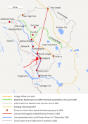
China's claim lines were far east in 1950s and then 1960 moved up much more after India rejects 1959 offer. After 1960's China and India fought the war and the post 1960s claim line of China's is basically that one your maps show and my maps show as the pink dotted line.

This is already been moved west and then west and then west and the control line (blue) has moved west and west and west.
 

ougoah

Brigadier
Registered Member
Ask why China despite winning 80% of total dispute is unwilling to allow India to take the remaining 20% and demarcate the border basically as the blue line with small variations here and there of course of nothing much in area.

Why not?

Why is China insistent on this remaining 20% going towards being a buffer as opposed to giving it to India?

Well because it's obvious! China thinks India is treating China as an enemy nation and constantly working against China in every way on every level since 2010.

Why give an enemy nation land for keeps? Of course buffer is preferable. Since China has the strength over India (yes even here in the most remote part of China and within a day's drive from India's capital) China is insisting on this area being buffer rather than Indian controlled or even Indian patrolled as a matter of frequency.

China went in to occupy a lot of this remaining 20% duisputed land to force India to accept either a buffer or to demarcate line in China's will. India is refusing at places other than Pangong. At Pangong India could no longer wear the political humiliation because it was so high profile and easily understood. It settled for a more complex to understand bargain so that it could sell it off as a PR victory of PLA has retreated! Conveniently forgetting that PLA had advanced before occupation and PLA disengaged only at India' agreement to also go back and to not step food in again - a buffer.

Elsewhere India is refusing to agree to establishing this area as a buffer because it means not gaining anything from total dispute and while 80% goes to China, 20% goes to buffer which China is comfy.
 

twineedle

Junior Member
Registered Member
It is impossible to lose land you never controlled

Anyway, this is probably how the Hot springs buffer zone would look like (Buffer zone in gray)
 

Attachments

  • Hot springs.jpeg
    Hot springs.jpeg
    274.6 KB · Views: 2

Xizor

Captain
Registered Member
If Shukla's map is correct, surely there would be some other source using it? Yet that map literally does not exist anywhere else. Shukla pulled it out of thin air. Than again, you claim historic Indian and CIA documents, Satellite analysts like Detresfa and Nathan Ruser, and google are wrong, and Shukla is right, despite literally no evidence supporting Shukla.
Shukla's maps are the only ones using Patrol Point 17A to Patrol point 19 in the verbiage

Unless you can furnish other maps that paint a different picture of Patrol points, the matter when discussing Patrol points shall be according to Ajai Shukla's depiction.
 

ougoah

Brigadier
Registered Member
It is impossible to lose land you never controlled

Anyway, this is probably how the Hot springs buffer zone would look like (Buffer zone in gray)

This is about land that both want.

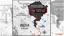
See here with the total shaded area. This is the "total dispute".

China has long won 80% of it and wants to establish the remaining 20% as a buffer if India refuses to demarcate.\

Why does China want to demarcate a border? Because that would mean India can never formally claim Aksai Chin if it agrees to demarcate a line.

the next best thing for China would be to set up a buffer so that at least the Indians can't really reach Aksai Chin becasue they can't step into the buffer and if they do, China has diplomatic ammunition and ask the Indians to leave without needing to tackle them again. That's the main thing.

Chiina wants to avoid these hugging fests with Indian troops. A buffer will separate troops for good.

WhatsApp-Image-2020-09-30-at-17.51.55-1024x576.jpeg
 
Status
Not open for further replies.
Top