Ladakh Flash Point

Status
Not open for further replies.

ougoah

Brigadier
Registered Member
So now everything is about the pink dotted to blue.

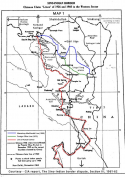
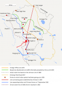
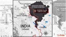
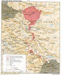
This is much more into India's side (albeit still dealing with disputed territory) than China's 1950s claim line and much more into India's side than what 1959 offer would have looked like which would be settlement between LAC (pink dotted or shown in both maps twineedle posted recently) and blue line which is even more into India than China's 1950s claim line.
 

ougoah

Brigadier
Registered Member
Now twineedle wants to make it seem that China has long controlled the area between pink dotted (LAC) and blue line. This isn't the case.

Think about it. If this were true, why the f**k would this thread be a thing? Why the "stand-off"??! lol

If China controlled this area and India knows China controlled it, how India has made this monumental fuss over a piece of land China already controlled for decades.

The truth is China has not controlled it for decades and it's only controlled east of blue line. This last remaining disputed stretch has been basically a no-man's land for a long time with both sides patrolling and attempting to camp and settle and build in varying frequency and effort of attempt until recently.
 

twineedle

Junior Member
Registered Member
Subject : Gogra (PP17A to PP19)

@twineedle

Bold 1: Yes detresfa is unreliable. I have always regarded him as a foreign analysts pandering to the Jai Hind crowd in Twitter. Can you link a post where I badged him as credible?


Bold 2: Have you provided any challenging ideas regarding Patrol Points of Gogra?

Until then, Ajai Shukla's description of Patrol Points and LAC are to be taken as true.

Bold 3: Patrol Point discussions are irrelevant?!

It is very much relevant. And LAC is clubbed along with the Patrol points.

View attachment 70332
I already said patrol point 19 is behind the red dot at Kongka la in this image, and even provided a possible point to its specific location, which you rejected. And just because Shukla draws a diagram does not make him right. If I drew a map showing the patrol points ten km west of the LAC, would you believe that?

By now, you are proving that you will only discount anyone supporting the Indian narrative, regardless of their evidence or qualifications. Guess you canoot accept the fact that you have no evidence of any buffer zone, which means India is still enforcing its claim line.
 

twineedle

Junior Member
Registered Member
A lot of regurgitated garbage.

You who followed Ajai Shukla's mapping of Patrol points is now distancing from them because it'll show that India lost to China wherein Buffer Zones where created in its own territory.

A quick change of colors if there was one.

Next time, don't vomit unrelated garbage and write senseless essays.

There is no constructive talks to be made here when you have a different take on what LAC is.
Simple question. Do you have clear evidence of a buffer zone in place, or China impeding Indian patrols behind the lac in any way? If not you are wrong, and by extension there is no evidence that India isn't patrolling the lac as normal.

Remember, the burden of proof is on the claimant.
 

ougoah

Brigadier
Registered Member
Face it. With this stand off China has gone beyond the blue line where they actually control and into disputed no man's land - pink dotted to blue.

All this is already well beyond what China bargained for in the 1950s. Even the blue line is more into India. Behind the blue line is India's claims. thousands and thousands of kilometers squared of Indian claims. West of the pink dotted line is India. China claimed to only east of blue line 70 years ago and now have been happy to settle with 1959 offer which would be between pink dotted and blue line. At best for China it gets pink dotted line as border which is three to ten steps ahead of India.
 

ougoah

Brigadier
Registered Member
This affair is SO freaking easy to understand if only I could use a pen and draw the entire history. It's so obvious that China's gained and gained land in the total dispute throughout history. It's already clear to anyone who can read these maps properly and carefully.

Don't worry though, none of this is Indian territory. All of it has been and is over disputed land. Neither China's territory proper or India's have been invaded. When China managed to invade into India proper during the war, they gave back every square mm to India in exchange for recognising Chinese new control - blue line. This blue line is 30km nearly deep into dispute at Aksai Chin and kms deep elseshere where the dispute is thinner.


new.png

Aksai_Chin_Sino-Indian_border_map.png

WhatsApp-Image-2020-09-30-at-17.51.55-1024x576.jpeg


China_India_western_border_88.jpg
 

twineedle

Junior Member
Registered Member
View attachment 70333
Note the Legend -

There are two LAC.
Indian LAC
and
China LAC (intended).

The LAC some map denote now seem to be the intended China LAC or roughly along it.
If Shukla's map is correct, surely there would be some other source using it? Yet that map literally does not exist anywhere else. Shukla pulled it out of thin air. Than again, you claim historic Indian and CIA documents, Satellite analysts like Detresfa and Nathan Ruser, and google are wrong, and Shukla is right, despite literally no evidence supporting Shukla.
 

ougoah

Brigadier
Registered Member
Guys please stop arguing about Shukla. Just give that a rest. Focus on what is more tangible and easily understood. The picture is clear as day. Use the four maps I just posted to make claims on where things are etc if you can edit them and point on them.

e.g. we understand from the latest US and Indian official sources that Gogra, Demchok (not shown on most maps here), and possibly Depsang (who knows what parts exactly since it's HUGE) are still being contested and standoff tensions are yet to have disengagement and buffer. Although automatic buffer is there I assume. Just like there was in the past with maybe 10 to 20 metres of separation.
 

twineedle

Junior Member
Registered Member
Now twineedle wants to make it seem that China has long controlled the area between pink dotted (LAC) and blue line. This isn't the case.

Think about it. If this were true, why the f**k would this thread be a thing? Why the "stand-off"??! lol

If China controlled this area and India knows China controlled it, how India has made this monumental fuss over a piece of land China already controlled for decades.

The truth is China has not controlled it for decades and it's only controlled east of blue line. This last remaining disputed stretch has been basically a no-man's land for a long time with both sides patrolling and attempting to camp and settle and build in varying frequency and effort of attempt until recently.
Because China tried to push beyond the dotted line in several sectors, including Galwan, Hot Springs, Depsang, and even Demchok. In Galwan the conflict happened west of the dotted line. In Depsang,media reports indicated that India has been blocking Chinese patrols like China blocked Indian patrols. In Hot Springs the sat images are pretty self explanatory, and in Demchok the video posted by local nomads showed Chinese attempting to cross the river to reach the dotted line.

You are forgetting that there is still a lot of land China claims west of the dotted line, this standoff can be interpreted by the Indian side as a way for China to push the dotted line west. Remember that prior to September, one of the conditions China gave of restoring status quo ante was India vacating Dhan Singh Thapa. This is clearly because in the first map by Praveen Swami, China's 1959 claim goes through finger 2.

Yes China already seized most of the disputed territory in the western sector and following years later. Nobody is saying otherwise. Yet many analysts, including personal favorites here like Sawhney and Shukla, believe that China wants to secure beyond the dotted line. I actually agree with them, although they of course have a very different(and incorrect) opinion of where the dotted line is.
 
Status
Not open for further replies.
Top