Ladakh Flash Point

Status
Not open for further replies.

Xizor

Captain
Registered Member
You still have not provided any evidence that the map presented on google earth or the very same satellite images you use is incorrect. According to you, when one person says something and ten people say something different, those ten people's claims should be discounted regardless of their testimony.

But the location of pp19 was never teh main point of our discussion. I was arguing that there is no evidence of any buffer zone or even any evidence of changing Indian patrols, since there is no evidence of any Chinese activity outside of that one post. Detresfa, who you yourself posts marks it as 6 kmf from INDIA"S CLAIM LINE. Are you saying he is not creddible?


Here is the image you yourself posted. Now compare it to where the lac is(the actual lac, not the shukla lac which does not apear on any other maps.) It isn't hard considering there are no differing perceptions at the moment. Interestingly, I have noticed you have never marked an lac on your diagrams, probably to help your debunked narrative of Chinese victory/shifting lac. HInt: THe lac (Indian claim line) is about 6km west of the confluence. Surey it shouldn't be hard for you to mark.


Please, Log in or Register to view URLs content!
Another hint: THe patrol points are a few hundred meters behind the dotted line. The same one in the image posted by @ougoah
Where exactly they are is debatable, but irrelevant knowing the above.


View attachment 70306
In gogra, pp19 is most likely somewhere West of the Red dot at Gogra.

BTW, I do not think it has been mentioned that China has always had a small border outpost there for decades. However, only recently it was upgraded from a small post to a major base, perhaps with some artilery and armor, etc. But if China had always had a small post there, how could India patrol there, as Shukla claimed(even if India claimed it fell behind its lac, which it never did)

But anyway, I do admit I was mistaken to take Shukla's map seriously just for the sake of this discussion, even though they contradict images by detresfa and others. That simply changed the subject of this exchange from evidence of a buffer zone, your initial claim, to an irrelevant debate about the exact locations of patrol points. You still ahve not presented any CLEAR evidence, and the images you have posted contradicted your and Shukla's claims. Although there are differing perceptions elsewhere, the lac at Gogra that both India and CHina recognize is quite clear and has not been shifted, even though you are trying to make it so. Nor have you provided any evidence that google is wrong and that India has not claimed the same lac it has for decades, instead of the one SHukla created out of thin air.

And once again, even if there is a buffer zone, and there will likely be one if/when disengagement is completed, that buffer zone will include Chinese territory like the ones at Pangong and Galwan did, simply because of how close the pps are to the lac. That is simple logic.
A lot of regurgitated garbage.

You who followed Ajai Shukla's mapping of Patrol points is now distancing from them because it'll show that India lost to China wherein Buffer Zones where created in its own territory.

A quick change of colors if there was one.

Next time, don't vomit unrelated garbage and write senseless essays.

There is no constructive talks to be made here when you have a different take on what LAC is.
 

Xizor

Captain
Registered Member
So by your logic, the buffer zone never included Indian territory, just Indian claimed territory. That goes against several preconceived narratives here.
The buffer zone was created in Indian patrolled Territory.

Your logic falls short when considering the fact that Indian Government still considered Gogra a focus of existing Issues.

Going by the Google LAC of yours, all patrol points (even PP19) are within LAC. There should be no issues there (since satellite images say that Chinese camps are 15 km away from Gogra post.)

Are you even listening to your words?
No, you are desperately concocting tales to cover up for the shortcomings of the new power at helm in India.
 

Xizor

Captain
Registered Member
I

I highly doubt China offered that line to India after 1959. And there are multiple sources for China's claims.

Shows China claiming the entire valley and up to around finger 2.

View attachment 70322
The CIA map is fascinating, it shows the lac during the 60s far west of what it is today.
Claims.

Not LAC.

Claims.

China and India hasn't agreed on an LAC for half a century. You attempt to deflect the discussion from LAC to claims.
 

Xizor

Captain
Registered Member
But the location of pp19 was never teh main point of our discussion. I was arguing that there is no evidence of any buffer zone or even any evidence of changing Indian patrols, since there is no evidence of any Chinese activity outside of that one post. Detresfa, who you yourself posts marks it as 6 kmf from INDIA"S CLAIM LINE. Are you saying he is not creddible?


Here is the image you yourself posted. Now compare it to where the lac is(the actual lac, not the shukla lac which does not apear on any other maps.) It isn't hard considering there are no differing perceptions at the moment. Interestingly, I have noticed you have never marked an lac on your diagrams, probably to help your debunked narrative of Chinese victory/shifting lac. HInt: THe lac (Indian claim line) is about 6km west of the confluence. Surey it shouldn't be hard for you to mark.


But anyway, I do admit I was mistaken to take Shukla's map seriously just for the sake of this discussion, even though they contradict images by detresfa and others. That simply changed the subject of this exchange from evidence of a buffer zone, your initial claim, to an irrelevant debate about the exact locations of patrol points. You still ahve not presented any CLEAR evidence, and the images you have posted contradicted your and Shukla's claims.
Subject : Gogra (PP17A to PP19)

@twineedle

Bold 1: Yes detresfa is unreliable. I have always regarded him as a foreign analysts pandering to the Jai Hind crowd in Twitter. Can you link a post where I badged him as credible?


Bold 2: Have you provided any challenging ideas regarding Patrol Points of Gogra?

Until then, Ajai Shukla's description of Patrol Points and LAC are to be taken as true.

Bold 3: Patrol Point discussions are irrelevant?!

It is very much relevant. And LAC is clubbed along with the Patrol points.

Screenshot_20210302-060634__01.jpg
 

Xizor

Captain
Registered Member
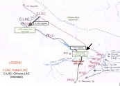
Meera Ajai mp.jpg
Note the Legend -

There are two LAC.
Indian LAC
and
China LAC (intended).

The LAC some map denote now seem to be the intended China LAC or roughly along it.
 

ougoah

Brigadier
Registered Member
I

I highly doubt China offered that line to India after 1959. And there are multiple sources for China's claims.

Shows China claiming the entire valley and up to around finger 2.

View attachment 70322
The CIA map is fascinating, it shows the lac during the 60s far west of what it is today.

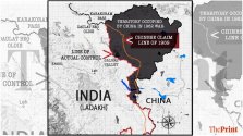
That top map shows China's claim that is shown to non-aligned states. It shows what is basically LAC of old and new. The bottom map shows China's 1956 claim line as pretty much the offer from 1959. The LAC red line is still the same LAC shown in the top map that is the claim line given to non-aligned states and the LAC of old and new.

From your own maps, you can see that China's 1958/9 claim and offer is really good for India and now China has much more than that.

These maps are excellent evidence that show in the past, China's claims were pretty much the same as it is now. I don't know how you're unable to read these maps.

Both the maps you have shown are basically verifying my point. China's claim line of 1950s to 1960s were much more east of where Chinese control now. Which mean they have gained huge swathes since then - i.e. the blue line of Chinese control is now much more west and towards India than China's 1950s and 1960s claim lines and contol. China's 1959 offer was also far more favourable for India that the pink dotted line is.

The pink dotted line is basically ALMOST identical to the "LAC" of old in both your maps here!

lol
 

ougoah

Brigadier
Registered Member
So by your logic, the buffer zone never included Indian territory, just Indian claimed territory. That goes against several preconceived narratives here.

The buffer zone is on the remaining disputed land. The rest China already controlled.

It is neither Indian or Chinese territory but territory both still claim. China has already won 80% of the total dispute since it controls everything east of the blue line.

The remaining 20% of the still disputed (the area between pink dotted line and blue lines) is being fought over. China claims it as much as India does.

But just west of this is India and just east of this is the 80% of land China already won since 1962.

And about this last remaining buffer/disputed zone... China never controlled it like you want to claim. China only controlled it when it fought into India in 1962.

What happened was this. All of that area including Aksai Chin was disputed and fought over before 1962. Shown as whole shaded region in map below. Then China fought into India and went as far as about 150km from the edges of New Delhi.

China knew these positions are untenable and was then still a struggling nation dealing with other conflicts and just out of a civil war and WW2.

China told India in return for total ceasefire, China gets to keep everything east of the blue line (in general map) which means China won about 80% or so of the disputed land, but China will give back to India all the much greater advances made by PLA. With ceasefire, both sides could stop spending material and lives to fight over the new status from which China has made great advances into India proper.

WhatsApp-Image-2020-09-30-at-17.51.55-1024x576.jpeg
 

twineedle

Junior Member
Registered Member
A lot of regurgitated garbage.

You who followed Ajai Shukla's mapping of Patrol points is now distancing from them because it'll show that India lost to China wherein Buffer Zones where created in its own territory.

A quick change of colors if there was one.

Next time, don't vomit unrelated garbage and write senseless essays.

There is no constructive talks to be made here when you have a different take on what LAC is.
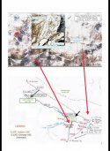
I already said I used his points simply for the sake of arguement, not knowing you would shift the discussion from evidence of the buffer zone to the exact location of the patrol points(which are behind the Indian claim line/google lac).

You still ahve not provided any evidence corroborating Shukla, or why detresfa and google are wrong, or that India's claims did not line with the lac on google maps. You have still provided zero evidence of a buffer zone. In fact, you haven't shown a single image of any Chinese positions other than the post 6km from the lac, which was first constructed decades ago.
 

ougoah

Brigadier
Registered Member
China has after 1962 also offered to demarcate the line for good and by then, the 1958 claim and 1959 offers were still roughly going to be LAC to Chinese 1950s claim line which is F4 to F8 and indicated generally in that map.

Your own maps show LAC as being pretty much same as pink dotted line which is China's overall intentionally low ball offer of deep into India demarcation. The LAC favour China heavily!
 

twineedle

Junior Member
Registered Member
Subject : Gogra (PP17A to PP19)

@twineedle

Bold 1: Yes detresfa is unreliable. I have always regarded him as a foreign analysts pandering to the Jai Hind crowd in Twitter. Can you link a post where I badged him as credible?


Bold 2: Have you provided any challenging ideas regarding Patrol Points of Gogra?

Until then, Ajai Shukla's description of Patrol Points and LAC are to be taken as true.

Bold 3: Patrol Point discussions are irrelevant?!

It is very much relevant. And LAC is clubbed along with the Patrol points.

View attachment 70332
Ok so detresfa, who has no interests in Indian politics, and is an experienced satellite analyst, is unreliable. But Shukla, a known politically minded blogger who has been proven wrong multiple times is reliable, even though all other analysts and sources are saying something different from him. Apparently Shukla's claims are more reliable to you than undeniable satellite imagery.
 
Status
Not open for further replies.
Top