Yeah I don't think the Americans are lying. It's too easy to call them out on lying here. While they have the motivations to, and this potentially does flare things up between India and China again, it's merely more an opportunity to share flare up info but embellishing and making this up is almost certainly untrue. Just like the same reason the CCP saying 4 PLA soldiers were killed by IA is almost certainly true as well. It's just too easy for someone else (India or even US) to say hang on that's not true.
We've been saying that there are other confrontations unresolved between the two since Indian military and government itself recognise that. It's just some self proclaimed experts who are so insistent on using 10km^2 satellite footage of one or two spots back from mid 2020 to claim there are zero confrontations. These Jai Hinds only care about securing their dreams PR victory, no intention to contribute any value and thought.
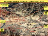
The southern dispute zone is rarely talked about. With recognition that Ladakh crisis flared up all three dispute stretches (the separate ones - Depsang to Galwan(Gogra/river), Pangong, and Demchok), the full picture makes complete sense. These make up the entire Ladakh dispute.
Dispute! PLA and China has not invaded India proper and it has zero intention to. These stretches have been outstanding disputes for nearly a century. China capturing Aksai Chin should be enough for China but clearly it considers ceding disputed territory to India something that isn't worth any positive return in the form of good will or whatever. They understand Indians better than we do.
If India gives agreements to stand behind disputed land and never set foot on it with patrols, there is every chance PLA will disengage from forward positions currently occupied. Since this is good enough for Pangong, it is good enough for Northern and Southern dispute stretches. Don't listen to the halfwits who are claiming that PLA disengaged at Pangong because India has southern bank of lake covered as if that's some militarily relevant tactic these days.
China just wants India to promise it will not patrol any disputed territory again and put all its troops behind those disputes. This arrangement worked for Pangong stretch so it should be effective elsewhere but PLA has delayed disengagement. Could be India refusing Chinese demands or China genuinely hoping to capture and control like Aksai Chin. One of the two.
We've been saying that there are other confrontations unresolved between the two since Indian military and government itself recognise that. It's just some self proclaimed experts who are so insistent on using 10km^2 satellite footage of one or two spots back from mid 2020 to claim there are zero confrontations. These Jai Hinds only care about securing their dreams PR victory, no intention to contribute any value and thought.
The southern dispute zone is rarely talked about. With recognition that Ladakh crisis flared up all three dispute stretches (the separate ones - Depsang to Galwan(Gogra/river), Pangong, and Demchok), the full picture makes complete sense. These make up the entire Ladakh dispute.
Dispute! PLA and China has not invaded India proper and it has zero intention to. These stretches have been outstanding disputes for nearly a century. China capturing Aksai Chin should be enough for China but clearly it considers ceding disputed territory to India something that isn't worth any positive return in the form of good will or whatever. They understand Indians better than we do.
If India gives agreements to stand behind disputed land and never set foot on it with patrols, there is every chance PLA will disengage from forward positions currently occupied. Since this is good enough for Pangong, it is good enough for Northern and Southern dispute stretches. Don't listen to the halfwits who are claiming that PLA disengaged at Pangong because India has southern bank of lake covered as if that's some militarily relevant tactic these days.
China just wants India to promise it will not patrol any disputed territory again and put all its troops behind those disputes. This arrangement worked for Pangong stretch so it should be effective elsewhere but PLA has delayed disengagement. Could be India refusing Chinese demands or China genuinely hoping to capture and control like Aksai Chin. One of the two.
Last edited:


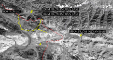
 nly a few meters from the lac" according to several Indian sources. I am guessing that is because unlike Hot Springs, China does claim beyond the LAC at one point. More on that below.