First sign of an EOTS for Kizielelma and/or MMU?
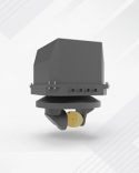
TOYGUN from Aselsan. No further information available as of yet:
View attachment 110523

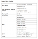
TOYGUN Electro Optical Sensor System is an aircraft integrated electro optical sensor and targeting system to be developed for combat manned and unmanned aircraft systems.
Areas of Use:
- Targeting
- Reconnaissance and Surveillance
General Features
- Video Stream Creation Task
- MW Infrared Imaging: A high resolution (at least 1280x1024 resolution) thermal detector will be used for the system to perform imaging in the MWIR band.
- Image Processing: Image enhancement functions (edge-corner smoothing, image sharpening, histogram equalization, black/white balancing, removal/minimization of fog, haze and atmospheric effects, supperresolution, turbulence correction and target evaluation) will be applied in the MWIR image channel. It will have moving and fixed target detection and tracking capability.
- Laser Marking Mission: In order to ensure that laser guided munitions hit the target precisely, laser marking can be performed on the target. Laser marking will be performed at 1064 nm wavelength and will be compatible with NATO STANAG 3733.
- Laser Range Finding Mission: It will be able to perform a laser range-finding mission in order to provide distance information of the target. The target distance will be found accurately up to a distance of at least 35 km. - Laser Point Tracking Mission: It will be able to detect and track the target marked by another platform. - Internal Alignment Mission: It will align the Laser Marker and Laser Target Tracker units according to the thermal image without the need for external equipment.
- Line of Sight Control Mission: According to the given coordinate, speed request and position request, the line of sight will be guided and the line of sight will be stabilized.
Navigation and Target Estimation Mission: The coordinates of a target on the ground will be calculated with the support of internal GPS / external INS / platform navigation data / internal inertial measurement unit.
- Video Target Tracking: The system will keep moving and stationary targets in the center of the image and calculate speed, orientation and coordinate information and share it with the outside world.
- Symbology Creation Task: Target, Orientation and Camera Status information will be displayed with text and graphics on the image outputs.
- Outside World Communication Task: There will be external interfaces for power, image transmission, GNSS Antenna, communication and control signals.


