PLAN SCS Bases/Islands/Vessels (Not a Strategy Page)

schlieffen

New Member
That is not to say that I actually believe PRC could negotiate with Soviet to get Outer Mongolia back. Mongolia was de facto independent for almost three decades by the late 40s, and given the balance of power between Soviet Russia and China (communist or nationalist) the chance of Soviet compromise is non-existent. That being said, IMO if it was not for the KMT who set it in stone in 1945, the PRC could at least try to negotiate with the Soviets and strike a deal to get some concessions elsewhere. For example, it did managed to convince the soviets to withdraw its garrison from Manchua, Port Arthur (Lüshun) and Xinjiang, so maybe (just maybe) they can trade the recognition of Outer Mongolia for soviet pulling its troops out of Mongolia. It would actually be very consequential as the soviet troops in Mongolian would later be a focal point of disagreement and great source of tension between soviet and china after the sino-soviet split. This is of course just hypothetical.

Sorry for getting far off topic but IMO historical territorial change is not completely irrelevant to our discussion of SCS. As the moderator must have released it is nearly impossible to run this thread with absolutely no tolerance of political and strategic discussion. They just swing back every few days if not hours.
 

vesicles

Colonel
The first Chinese regime to recognize Mongolian independence was the KMT government, who in the Sino-Soviet Treaty of Friendship and Alliance (中蘇友好同盟條約) signed on 14th Aug 1945 agreed to acknowledge the result of Mongolian referendum, which was duty held two month later and overwhelmingly supported independence. The ROC recognized the Outer Mongolia state the following year.

But the map in question was dated in 1938, 7 years before the KMT signed the Sino-Soviet Treaty of Friendship and Alliance (中蘇友好同盟條約) with the Soviets...

So in 1938 when this particular map was shown, the Outer Mongolia was still part of China.
 

schlieffen

New Member
But the map in question was dated in 1938, 7 years before the KMT signed the Sino-Soviet Treaty of Friendship and Alliance (中蘇友好同盟條約) with the Soviets...

So in 1938 when this particular map was shown, the Outer Mongolia was still part of China.

This is exactly what I said in my first post. I’m not sure where our disagreement lays? I was mainly pointing out that you assertion of Mongolia splitting form China after 1949 was incorrect.


As we both agree, in 1938 Outer Mongolia was still technically part of China, so left it out on the map was surprising. I said surprisingly honest because any sane people would have to admit that by later 30/40s, Mongolia was a lost course for China. It has been de facto independent since 1912, and with the exception of a brief expedition by general Xu Shuzheng between 1917-19 (taking advantage of Russia revolution), China was to never again lay effective control over outer Mongolia.


There are several possible explanation. For example, in 1938 China’s main adversary was Japan, and Soviet Union was the ONLY open ally of China in its war against Japan until 1940 (the US was still strictly neutral, and American export to Japan actually peaked in 1938). The author probably don’t want to target soviet Russia in a school textbook. There are other possibilities, but I won’t further elaborate as we're getting to far off-topic.
 

Jeff Head

General
Registered Member
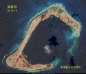
Subi Island can see runway being built.
subi1-jpg.20491
That is an excellent picture...dated 10 days ago.

Makes plain that the construction of the airfield is indeed underway.
 

ahojunk

Senior Member
Please, Log in or Register to view URLs content!

2015/10/24 19:02:58

201510240014t0001.jpg
Photo courtesy of Maritime and Port Bureau

Taipei, Oct. 24 (CNA) Taiwan has finished construction of its southernmost lighthouse located on Taiping Island in the South China Sea, the Maritime and Port Bureau said Saturday, adding that the lighthouse could both improve navigational safety and assert the nation's sovereignty.

The 12.7 meter-tall lighthouse will help guard Taiwan's various national interests, said the bureau's deputy head Lee Yun-wan (李雲萬).

The Taiping lighthouse has a range of 10 nautical miles, while it will also be automated and regularly maintained, Lee said.

It is unlikely that the lighthouse will be affected by the two lighthouses on Huayang Reef and Chigua Reef in the South China Sea, which the Chinese government inaugurated earlier this year, Lee said in response to media inquiries.

The Chinese lighthouses are far away from the Taiping lighthouse, he explained.

With an area of 0.49 square kilometers, Taiping Island is the largest of the Spratly Islands in the South China Sea, which have been at the center of heated territorial disputes involving Taiwan, China, Vietnam, the Philippines, Malaysia and Brunei in recent years.

Taiwan has improved airport facilities on the island and is also building a wharf, which is scheduled to be completed by the end of this year, ensuring that the island can be used for humanitarian tasks, the Ministry of National Defense said.

(By Chen Wei-ting and Lee Hsin-Yin)
 
Top