Ladakh Flash Point

Status
Not open for further replies.

eprash

Junior Member
Registered Member
Tibet is absolutely crucial for China Yangtze and Yellow River originates there not to mention the elevation of the plateau anyone controling the region can pretty much do deadly artillery strikes against China's heartland the same in the case of Aksai Chin it's the only place that connects Xinjiang and Tibet, That is not the case of Arunachel it's not a crucial land mass for China in fact Chinese leadership only started to claim the area as a way of leverage in negotiations with India for Aksai Chin, Both countries has their own reasons, For India their territory was determined by Britain, Aksai chin and Arunachel were part of British India, Tibet on behalf of Qing empire waged war but to no avail even resulting in De facto Tibetan independence from Chinese crown Qing court was smart enough to adopt a passive stance and not sign anything with the Brits regarding formalization of border to have plausible deniability in the future, For China Tibet was a part of China and was annexed from it by Imperial powers when it was at its weakest and regaining the territory is non-negotiable to end it's Century of humiliation and rejenuvate China's old glory, it's geopolitics and a clash of interests, personally I would have preferred India formally recognise Aksai Chin as part of China in return for Burang county (Mount Kailash) in the 50s and ended it once and for all
tl;dr damn brits.
 

Kakyan

Junior Member
Registered Member
Also, China can patrol to Finger 4, it was just a pull back. You indians also pulled back to finger 3. Meaning that you indians already acknowledged China's LAC claim up to finger 4.
False claim. Neither will patrol betwen F4 and F8. It will be a No Mans Land for now:

Please, Log in or Register to view URLs content!

pushed it !!
Again this baldy's claim is wrong. India says LAC passes through F8 and China says it is theough F4. So now F4 to F8 i disputed zone which will be a no man land from now.


What you provided is not a reference. It is just a mere image from ZOOM. It has ZERO creditability !!
Wrong it clearly shows where the LAC passes through ie right at Y junction. It uses the same LAC as marked by NOAA which is the official US govt agency for cartography.
You view the same on NOAA NESDIS too.

Indian analysts are not neutral so only third party maps are credible on this. Thus only NASA or EU maps can ascertain the actual truth
 

Kakyan

Junior Member
Registered Member
So, technically, India did lose 1000 sq km. If India claims they didn't lose it, then that means India is considering these regions as de facto part of China. You see the catch here?
Not really as those 1000 sqm in depsang were necer accessed by India for atleast 30 to 40 years as staed by a Ladakh corps commander himself and all neutral maps from NASA or EU or NOAA showd that 1000 sq km area (Depsang Plains) to be on Chinese side of LAC
 

Mt1701d

Junior Member
Registered Member
I'm afraid there is a snowballing effect in this forum and it's getting to the level of Indian ones the criticism aganist indian leadeship and right wing populace are indeed based on facts and justifiable but bashing India seems to get easy likes and new members are seeing it as a way for peer approval, We should probably stay away from that sort of circle jerk unless this thread want to devolve into another Bharat Rakshak
I think you do have a point but also somewhat inflated the level of supposed ‘Indian bashing’... the majority of this phenomenon is isolated in a few threads where India is a or the specific topic, 5 if I am not mistaken, with 2 being about specific events which would become irrelevant after the closing of the event including this one, saying that there is a snowballing effect on the whole forum is I think a little unfair since the majority of the forum doesn’t or rarely mention India... and the mentions are mainly a comparison of the two sides (this is outside of the 5 threads mentioned above), and I think that stating facts or sharing an opinion, with reasoning, shouldn’t be construed as bashing...
 

Nobonita Barua

Senior Member
Registered Member
False claim. Neither will patrol betwen F4 and F8. It will be a No Mans Land for now:


Again this baldy's claim is wrong. India says LAC passes through F8 and China says it is theough F4. So now F4 to F8 i disputed zone which will be a no man land from now.
How ridiculous!! WTH "India says LAC passes through F8" means? Be specific. What does this sentence mean?? Are all indians still in monkey era that never evolved?
He has no credibility. He is same person who falsely labeled a Pak Babur missile launch as CGI.
Who has credibility? You & your nation who think China is North America?
llllllllllllllll.jpg

Or neutral US , country with super intelligence gathering capacity that though Kim Jong Un was dead & China includes entire asia?
bbbbbb.PNG

Neutrality comes after both side's claim. You can't even find an official map of your own country.
 

Mt1701d

Junior Member
Registered Member
Yes third party maps from US or EU are far more reliable as they are neutral and not a party to this dispute which makes Indian claims non neutral.
While I generally agree with the perception that the US or EU should be neutral since they are not a party in the dispute however to claim they are completely neutral thus their maps can be taken as reliable is mistaken... they like everyone else including the disputing parties have their own agendas and thus such agendas will reflect on things such as maps as well, especially when concerning boarders, hence not reliable
 

Xizor

Captain
Registered Member
Not really as those 1000 sqm in depsang were necer accessed by India for atleast 30 to 40 years as staed by a Ladakh corps commander himself and all neutral maps from NASA or EU or NOAA showd that 1000 sq km area (Depsang Plains) to be on Chinese side of LAC
Please, Log in or Register to view URLs content!


The official revealed that in
Please, Log in or Register to view URLs content!
, from patrolling point 10-13, the scale of Chinese control of India’s perception of the LAC stood at about 900 sq.km.

About 20 sq. km in
Please, Log in or Register to view URLs content!
and 12 sq. km in Hot Springs area is said to be under Chinese occupation, the official said. In Pangong Tso, the area under Chinese control is 65 sq. km, whereas in Chushul it is 20 sq. km, the official said.


Same thing by another source -

Please, Log in or Register to view URLs content!


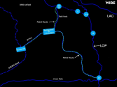
Of the more than 1,000 square kilometres in Ladakh along the LAC now under Chinese control after tensions erupted in May, the scale of Chinese control in Depsang alone is about 900 square kilometres. That would make it the largest chunk of Indian territory denied to Indian soldiers in a single swoop after the 1962 Sino-India war, a fact which surely warranted inclusion in an official speech to parliament by the raksha mantri.

The PLA has denied the Indian Army’s patrols access to five patrol points – PP 10, 11, 11a, 12 and 13 – which marked India’s limit of patrol, or LOP, by blocking them at Bottleneck/Y junction around 18 km inside the LAC
1613378368805.png


Just because India doesn't patrol a region doesn't mean it isn't India's, right?

That Corps commander has provided deniability for his corps but not a deniability for the country.

Ultimately, does that region belong to India? That question remains.
 
Last edited:
  • Like
Reactions: JSL

ougoah

Brigadier
Registered Member
There are 3 other features: Galwan, Gogra and Hot Springs, all of which are a win for the PLA.

As for North Pangong Tso... This is an interesting situation. I would think the PLA pulled back from those fingers because Indians on the south bank had overwatch, so it's tactically a bad place for the PLA to be. If a war broke out, their southern flank on Finger 4 would be completely exposed. It would've caused a lot of headaches in an actual war.

Which raises the question: Why did the PLA make that move into F4 to begin with? I think there's three possibilities:

1) It was a tactical error.
2) It was a diversion, to draw India's resources away from more important sectors.
3) The PLA wanted to gain an expendable chip that it could throw away at the right time (e.g. after a US election), while keeping everything else that it actually wanted to keep.

I think #3 is most likely, but regardless of the right answer, by moving back from F4 the PLA's tactical and operational position has actually improved, while strategically nothing has changed, despite the bollywood victory parade by India. And overall, the situation still vastly favors China:

Please, Log in or Register to view URLs content!

That's an interesting insight. I never thought of it that way before.

If that's the case then it prompted India to match by seizing locations south of PangongTso.

Except the Indian seizing of southern parts were pretty quickly reversed. Indians always held Chushul. They didn't manage to hold onto Reqin. Black top and Hlemet top were both bilaterally recognised as Chinese iirc and PLA does hold those tops while Indians have camps right next to PLA.

The Indians basically had camps withing throwing range of PLA forward positions from Galwan valley down to Black Top.
 
Status
Not open for further replies.
Top