Exactly. Good. I'm happy.See for yourself, it is clearly marked in the image you yourself posted.
You are using an out of date browser. It may not display this or other websites correctly.
You should upgrade or use an alternative browser.
You should upgrade or use an alternative browser.
Ladakh Flash Point
- Thread starter Mt1701d
- Start date
- Status
- Not open for further replies.
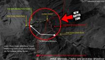
The initial disengagement was limited to hot springs, and was about clearing the red circle in the above image. This image from july, when initial disengagement occured, showed that. Obviously, the disengagement was not completed.Simple question -
1. Where exactly did the initial conflict or standoff take place in Gogra?
2. What were the terms of initial disengagement?
The rest depends upon your intelligence but I don't think even that would help here.
You insist that final disengagement hasn't been achieved. I can't see anyone Gere denying that. Especially when disengagement talks are happening.
compare that to the above image
Are you talking about Galwan here?There is no Chinese activity in the 6km of area between China's post and the 1962 lac(Indian claim line). Looks like a buffer zone extending 6km into China falling your logic. If you disagree, please present satellite evidence showing otherwise.
If so, let me borrow your own post

And where exactly are those "armored divisions?" the earlier satellite images near hot springs showed China has a big camp a few km on its side of the Indian claim line, as Abhijit Iyer wrote about last May, yet there has not been a single image of any Chinese structure near any of the Indian patrolling points near Gogra. If you disagree, feel free to post one. As the above image clearly shows, the conflict point was in Hot Springs, not gogra.*Sigh*
Let's discuss at length.
At the two ends of the 15 km gap (between PP17A and PP19)
1. There is an Indian post at PP17A. No Indian post beyond.
2. There is a Chinese post, armored divisions at/near PP19.
I think enough has been said.
Guess you cannot accept that effectively several km of Chinese territory in Goga sector has become a buffer zone, and China has falied to reach its claim line in Hot Springs.
I was talking about gogra. Disengagement in Galwan already happened. You are sounding more and more confused in every post. And I am glad you agree that chinese territory has been turned into a buffer in Galwan.
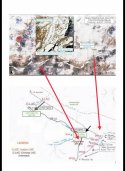
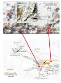
And in Galwan, you are claiming that google is wrong, the CIA is wrong, historical Indian documents are wrong, and the Indian governments historic claims are wrong. As far as India is concerned, there has always been one lac, plainly marked here for anyone interested in actual facts. China of course claims west. China attempted to shift the lac west in order to prevent Indian occupation of the valley and infrastructure construction but failed.
Last edited:
!!!And where exactly are those "armored divisions?" teh earlier satellite images showed China has a big camp a few km on its side of the Indian claim line, as Abhijit Iyer wrote about last May, yet there has not been a single image of any Chinese structure near any of the Indian patrolling points near Gogra. If you disagree, feel free to post one. As the above image clearly shows, the conflict point was in Hot Springs, not gogra.
Guess you cannot accept that effectively several km of Chinese territory in Goga sector has become a buffer zone, and China has falied to reach its claim line in Hot Springs.
Are you even reading your own posts?

Confused, me?I was talking about gogra. Disengagement in Galwan already happened. You are sounding more and more confused in every post. And I am glad you agree that chinese territory has been turned into a buffer in Galwan.
Says the person who lacks the spine to properly address someone, properly submit upto date satellite images and beats around.
Gogra has Chinese camp at or near PP19.
China hasn't had a buffer zone created in its territory. If anything, a buffer zone lies between PP17A and PP19.
Surely you have some evidence for that claim? A Chinese camp will be easily spotted by sat images.Confused, me?
Says the person who lacks the spine to properly address someone, properly submit upto date satellite images and beats around.
Gogra has Chinese camp at or near PP19.
China hasn't had a buffer zone created in its territory. If anything, a buffer zone lies between PP17A and PP19.
I will wait.
Le me correct youI was talking about gogra. Disengagement in Galwan already happened. And I am glad you agree that chinese territory has been turned into a buffer in Galwan.
If the LAC shown is traditionally Indian then
Buffer zone has been created in what is both Chinese and Indian patrol regions.
If the LAC is a new one and the old one has been disregarded ,
then majority of the buffer zone will fall into Indian patrol zone.
This border Patrol commander thinks LAC has been shifted.
This twitter handle @nmenonrao submits that China never claimed upto the present LAC in 1960.
The Indian LAC that existed at Galwan during 1970s to 2000s remains a mystery.
- Status
- Not open for further replies.

