You do not even know China's own claims in gogra/Hot Springs. I have already provided maps showing the lac in that secotr compared with Chinese claims. China's nearest positions are still behind the 1962 lac, well beyond what China claims. India has done a mirror deployment within the Chinese claim line.You avoid all decent debate by not even setting and stating clear things.
I'll set some statements to set an example for you to follow.
India got proven worthless and a coward who surrendered - true because it refused to escalate into war despite PLA unprecedented capturing and control of F4 to F8 at Pangong. It was PLA who captured and stayed while IA tried to push it out but failed. PLA seems to have also captured and stayed in other parts of Ladakh dispute at the other two stretches - Depsang/Galwan and Demchok. These are all undeniable facts. No one is saying PLA captured Indian controlled parts. Only disputed stretches... something India was never able to do and hold for negotiation bargaining power.
De-escalation at Pangong came at the price of India needing to retreat behind F3 and staying there. This takes their access to their claim of F4 to F8 away. China in the past constantly asked India to agree to a firm border here with negotiation to settle it somewhere between F4 and F8 which also happens to be the fluid LAC.
India's own four star general is on public record saying India "transgressed LAC" more than 5 times as often as PLA... where he's talking about he didn't specify but come on it's one or all of the three stretches as Ladakh.
India and US both agree that PLA is currently still occupying some portion of disputed stretches at Galwan-Depsang (Gogra) and Demchok.

You are using an out of date browser. It may not display this or other websites correctly.
You should upgrade or use an alternative browser.
You should upgrade or use an alternative browser.
Ladakh Flash Point
- Thread starter Mt1701d
- Start date
- Status
- Not open for further replies.
Unbiased? GOOGLE?What's wrong with google Earth? Don't like unbiased sources? The maps I have presented contradict Ajai Shukla's claims.
An American company with an Indian origin CEO. Also part of the PRISM program of US.
Very "unbiased" .
Already done it, but will do again. This was from late Feb. Compare it with the other maps I have posted, you will know exactly where all deployments areOkay show me "up to date" images of Gogra HS?
Yes. Has been analyzed and discussed to death over a week ago.
It shows (allegedly) Chinese armored columns and post just adjacent to PP19.
Certainly sits well with the well published claims of China stopping Indian patrols through forward deployments. There are artillery units at the hills behind the post.
Except India has mirror deployments within the area China claims. Hence "eyeball to eyeball standoff" as described in Indian media.Yes. Has been analyzed and discussed to death over a week ago.
It shows (allegedly) Chinese armored columns and post just adjacent to PP19.
Certainly sits well with the well published claims of China stopping Indian patrols through forward deployments. There are artillery units at the hills behind the post.
Compare that image with this analysis that I already posted,
The yellow bulge is the location of Indian mirror deployments.
Attachments
-
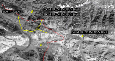 IMAGE-2.png756.5 KB · Views: 2
You do not even know China's own claims in gogra/Hot Springs. I have already provided maps showing the lac in that secotr compared with Chinese claims. China's nearest positions are still behind the 1962 lac, well beyond what China claims. India has done a mirror deployment within the Chinese claim line.
I do know China's own claim.
Here are the two northern dispute stretches. And again shared and explained for the nth time.
You do not understand history and you cannot bare to see how China is humiliating your precious supa powa. I can explain it all very comprehensively again for the record but one can also read the last 50 pages to understand.


You see China claims a lot and it captured and controls 90% of its claims and disputes with India. This is fair for both since disputes are not part of established territory and sovereignty. You can't blame China for taking those disputes. It has already won Aksai Chin.
China's general claim also shifts a lot depending on strength and strategy. The pink black dotted line is formal claim and the blue line is the old actual position of PLA and behind it was Chinese "control". India claims well behind the blue line.
Now we are at the pink black dotted line with Pangong disengaged because India agreed to not walk on it. The other parts that's between this dotted and the blue has PLA occupation in uncertain degrees. The entirety of Chinese claims do probably run up to and sometimes further than this dotted line. China is intent to send this message to India that India salami slicing (which was the case building up to this crisis) and increased patrols of still disputed (dotted to blue stretches) will not be accepted. PLA moved in to capture. IA useless to push PLA out and India agreed that in return for PLA disengagement (2 steps forward and 1 back), India will also take a step back and stop patrolling disputed stretch. This is a huge gain for China.
As for the norther and southern dispute stretches, PLA apparently hasn't even disengaged possibly because India has yet to agree to China's terms of disengaging PLA.
All of this is confirmed by US gov now and India's gov was only accountable enough to state that there are "problems" with disengagement at Depsang, Gogra, Hot Springs, and Demchok. If I recall correctly, they mentioned those four. I may be wrong about that and it seems that Depsang isn't an issue.

Now @twineedle please summarise in plain EXACT simple english what your claims are. Make them very SPECIFIC please. Don't use the typical wishy washy semantics that Indian love. Word games are tiresome when your focus is truth and results.
I understand one of your main points is that China has not captured any territory Indian controlled in the past. This is absolutely 100% true as far as us observers are privy to.
What are the rest of your claims and points?
I understand one of your main points is that China has not captured any territory Indian controlled in the past. This is absolutely 100% true as far as us observers are privy to.
What are the rest of your claims and points?
Already done it, but will do again. This was from late Feb. Compare it with the other maps I have posted, you will know exactly where all deployments are
And now please explain what you are trying to say with this "piece of evidence".
I'm seriously so lost on what you are claiming with random out of context snap shot dateless forward position satellite photos.
BTW this is a photo of a location dotted and pointed to in red below... FARRRRRRRRR beyond what PLA controlled and status quo.

You can see these areas are beyond blue line and pretty much at the edge of what China claims (dotted pink black line).
Now explain what you mean to say with all this random contextless satellite photo.
Last edited:
Whenever he shifts from the "LAC" to "claims", it'd be good to raise the fact that India claims all of Aksai Chin.I do know China's own claim.
Here are the two northern dispute stretches. And again shared and explained for the nth time.
Ooo. What a bold statement. Aren't you engaging in speculation here from a mere statement?eyeball to eyeball standoff" as described in Indian media.
Where are mirror deployments in the map you showed?
Coupled with the recent statements from India and US, it's pretty clear.
@ougoah He seems to be saying that China has not stopped India from patrolling in Hot Springs and Gogra. He says that even though there are Chinese posts, there is a mirror deployment to have an "eye to eye" standoff.
In that case, the document from Indian government as well as US to its government are lies or hollow.
Interesting.
Whenever he shifts from the "LAC" to "claims", it'd be good to raise the fact that India claims all of Aksai Chin.
Ooo. What a bold statement. Aren't you engaging in speculation here from a mere statement?
Where are mirror deployments in the map you showed?
Coupled with the recent statements from India and US, it's pretty clear.
@ougoah He seems to be saying that China has not stopped India from patrolling in Hot Springs and Gogra. He says that even though there are Chinese posts, there is a mirror deployment to have an "eye to eye" standoff.
In that case, the document from Indian government as well as US to its government are lies or hollow.
Interesting.
Yes China hasn't and shouldn't be able to stop Indians from patrolling west of these points. These are finite points in space. The Indians could literally patrol 1m or less away from where PLA wants to settle. This area is at the edge of 1 dimendional finite points along a claimLINE (China's) and not about a 2 dimensional stretch of area like the Pangong dispute stretch. Before PLA action, China's positions were behind the blue line at Gogra HS and Galwan. If India wants a similar 2D buffer established like on Pangong, they need to provide China with concessions and agree to terms of negotiations.
Honestly the whole Ladakh crisis is so fucking easy to contemplate and understand with very little room for era and uncertainty. It's like explaining addition and subtraction to a high school maths student. It's not even complex like Middle Eastern affairs and most information is pretty transparent.
The only ones that need to snake around very obvious and well reported/admitted facts are those who need a PR soother "victory". They can do this by obfuscating, spamming, lying, and semantics play.
Last edited:
- Status
- Not open for further replies.