Indian Military News, Reports, Data, etc.

hamaoka123

New Member
Registered Member
The front line and the lac are literally the same thing in this context. Check Google Earth because it's pretty clear you have no idea where the lac even is yet you are trying to lecture me on it. I have also shown you multiple satellite images showing the lac in comparison to the Chinese pullback under disengagent.

You only further display your ignorance by claiming that the sources I presented are based on a post pangong to status quo, when none of them even mentioned pangong disengagent and were from 2020, months before China pulled back from pangong.

Again, check Google Earth. The "front line" is the same lac which has been in place since 1962. Nothing changed in 2020.

And which sources have I used which were biased towards Indians? Unless you think scmp, andalou, and al Jazeera are Indian biased sources lol. You're the one who consistently posts partisan and biased Indian sources and ignores all the satellite imagery I have posted showing no pla presence in Indian territory.

Final thing:

Front line and LAC are not the same thing in this context. The place where the Galwan valley clash occurred was centred in the buffer zone between India's LAC and China's LAC. Satellite imagery was given but you chose to ignore it.

"Check Google Earth because it's pretty clear you have no idea where the lac even is yet you are trying to lecture me on it."

Refrain from using an ad hominem as a point without structuring an argument to actually represent it

"You only further display your ignorance by claiming that the sources I presented are based on a post pangong to status quo, when none of them even mentioned pangong disengagent and were from 2020, months before China pulled back from pangong."
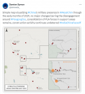
1710330614285.png

You legit gave me a twitter source that pertained to just "PangongTso" basic English comprehension has failed it appears.

"Again, check Google Earth. The "front line" is the same lac which has been in place since 1962. Nothing changed in 2020."

Frontline =/= LAC. By that logic what exactly happened in Galwan? Indian soldiers trying to swallow up buffer zone territory by constructing fortifications. That was the frontline.

"And which sources have I used which were biased towards Indians? Unless you think scmp, andalou, and al Jazeera are Indian biased sources lol."

Never said this, I said that the sources, some of which I have used were biased in favour of Indians. Which goes to show how even the Indian state media acknowledges territorial loss. See, you're just trying to use the red herring fallacy over and over and over again to defer the actual point of the argument. You can't even structure a coherent point so you resort to logical fallacies.

"You're the one who consistently posts partisan and biased Indian sources and ignores all the satellite imagery I have posted showing no pla presence in Indian territory."

You showed one drawing and one satellite image. Of which you ignored multiple of my own, including Bloomberg.


Your twitter source, under the main topic legit proves my point. Both sides withdrew but not to the LAC. This is a laughable cope.


And most importantly, it is Chinese territory. It is an integral part of Tibet which got siphoned over to India by the British.


I'm not going to bother with anymore petty disputes, because clearly you're arguing for the sake of your own ego, and not to find the truth.
 

twineedle

Junior Member
Registered Member
Final thing:

Front line and LAC are not the same thing in this context. The place where the Galwan valley clash occurred was centred in the buffer zone between India's LAC and China's LAC. Satellite imagery was given but you chose to ignore it.

"Check Google Earth because it's pretty clear you have no idea where the lac even is yet you are trying to lecture me on it."

Refrain from using an ad hominem as a point without structuring an argument to actually represent it

"You only further display your ignorance by claiming that the sources I presented are based on a post pangong to status quo, when none of them even mentioned pangong disengagent and were from 2020, months before China pulled back from pangong."
View attachment 126598

You legit gave me a twitter source that pertained to just "PangongTso" basic English comprehension has failed it appears.

"Again, check Google Earth. The "front line" is the same lac which has been in place since 1962. Nothing changed in 2020."

Frontline =/= LAC. By that logic what exactly happened in Galwan? Indian soldiers trying to swallow up buffer zone territory by constructing fortifications. That was the frontline.

"And which sources have I used which were biased towards Indians? Unless you think scmp, andalou, and al Jazeera are Indian biased sources lol."

Never said this, I said that the sources, some of which I have used were biased in favour of Indians. Which goes to show how even the Indian state media acknowledges territorial loss. See, you're just trying to use the red herring fallacy over and over and over again to defer the actual point of the argument. You can't even structure a coherent point so you resort to logical fallacies.

"You're the one who consistently posts partisan and biased Indian sources and ignores all the satellite imagery I have posted showing no pla presence in Indian territory."

You showed one drawing and one satellite image. Of which you ignored multiple of my own, including Bloomberg.


Your twitter source, under the main topic legit proves my point. Both sides withdrew but not to the LAC. This is a laughable cope.


And most importantly, it is Chinese territory. It is an integral part of Tibet which got siphoned over to India by the British.


I'm not going to bother with anymore petty disputes, because clearly you're arguing for the sake of your own ego, and not to find the truth.
You obviously have trouble reading, because I clearly stated that the lines used in the satellite imagery is the same lac used since 1962, as confirmed by Google Earth's lines.

And the map clearly shows sectors other than just pangong, including galwan, gogra, and hot springs. In all of those areas, pla is behind the Indian perception of the lac. Are you even able to read at this point?

All the articles I presented about the disengagent at Galwan were written well before the pangong disengagement was completed

That Bloomberg article was written before disengagent was completed, hence is useless in this discussion.

You're the one who's using logical fallacies here. You are claiming that some Indian media reporting is proof of India admitting it lost territory. However, you are ignorant of the fact that India doesn't have state run media in the same sense that China does, and all the Indian sources you posted are partisan in nature and clearly biased against the current Indian government. There are countless Indian media sources showing that India did not lose territory, but I have chosen not to use them in favor of more unbiased and neutral sources such as andalou and al Jazeera which debunk your sources.

As for your "front line" claims, China's initial incursion was 400 meters from the lac. After the disengagent it withdrew over 2 kilometers. You do the math as to where that puts pla relative to the lac. So in a way, you are actually right. China didn't withdraw to the lac, it withdrew behind the lac. In case you haven't realized, the lac is the red line used in the satellite images posted.

You have still failed to provide any concrete evidence which shows India lost territory. Just sources spreading politically motivated lies and here say from Indian opposition politicians. I have already provided unbiased sources from various international media sources and satellite images debunking them.
 
Last edited:

siegecrossbow

General
Staff member
Super Moderator
Absolutely true, are there any figures for what drones are fielded within the PLA western theater?

(Exception of civ drones)
51550914976_32efdf9463_k.jpg

51551145368_1d54edfefe_k.jpg

51550111902_2f52025532_k.jpg

51550893136_c88fea2ff3_k.jpg

51551607619_fd86dea05a_k.jpg
 
Top