Future PLAN orbat discussion

Tam

Brigadier
Registered Member
The Type-054 and Type-052B are essentially batches of test/experimental ships. It's not an issue if they get sold off.

It is an issue if the ships are still young enough, and it maybe a sign of things to come. Four relatively young warships --- warships --- that's always an issue. Even if its just one ship of its class, its still an issue.

As a Frigate, the Type-54 isn't obsolete per se, but many of the onboard systems look like one-offs and are therefore expensive/difficult to maintain.

Not really. Many of these systems are the same you have with the Jiangweis. While others, like the Type 344 and 364 radars, are shared with all the Type 054A and 052C/D. There is no unique system on the 054 at all.

---
I reckon the older Type-56 will probably be refitted with the TAS and VDS, at the next convenient opportunity.
But there's no rush since there are already 50 ships which do have the TAS and VDS.

It would be difficult for the Type 056, because it requires you cutout a hole in the back of the hull, along with being whats behind it may have been never designed with the space for the towed arrays.
 

AndrewS

Brigadier
Registered Member
The sea is simply not flat nor featureless. It is CURVED. Because the Earth is round, don't you get it? You cannot see what would be under the ground because of it.

The sea reflects clutter to the radar. Sea waves reflect radar, and back to the receiver. This creates noise and interference. Its like the sea is an ECM blanket of its own. Naval radars have to be extensively modified from their land based counterparts because of this. Even then, on certain areas, like littoral areas things underneath the water can reflect radar back and create readings.

Why do you think stealth was developed for ships, or at least partial stealth? If you are in AEW aircraft, from a far distance and with the Earth curvature considered, the ship is actually tilted back, and isn't standing straight up. If you increase the sloped angles of the ship on the side, that further steepens the angle of deflection, given you account for the earth curvature geometry. At the same time, the radar waves of the aircraft cannot reach the hull of the ship as it is too low and obscured by the curvature. That's why you see ships like the Shandong and the Type 075 have radar deflection features on their island but didn't have to bother on the hull.

Why do you think many ships have all these long flat sides that has a creased line and angled from above the crease line? Do you think that's for aesthetics? This design feature you can see from ships in France to Russia to China and across the world. Do you think that somehow they are all wrong? Every modern warship nowadays is a practice of partial stealth, with the Type 022, both LCS and the Zumwalt edging towards a more extreme practice.

The Type 056 itself is an exercise in partial stealth, something the Chinese Navy started with the 052B, and is refining with every new design. It also has a low silhouette, so its not going to show up so quickly.

All these ship design features help with warships hiding yes.
But even the Zumwalt still looks like a fishing boat, as per the US Navy.
Surface ships will still be detected by airborne radars at long distances.

---

You're missing the point.

My exact words were:

"No, the sea is essentially flat and featureless."

We all know the oceans follow the Earth's curvature and impose a radar horizon. That is obvious.

It is the primary reason why aircraft are better at finding ships, because aircraft can fly high, and also cover long distances.

But in the real world, from the point of view of an airplane looking for enemy ships - the sea is essentially flat and featureless.
The ship has nowhere it can hide. It can look smaller with stealthy shaping, but it can't actually hide anywhere.
 

AndrewS

Brigadier
Registered Member
It does. Four Type 056A can fire a total of 16 ASMs, which is already a heavy bunch.
16 small subsonic cruise missiles.
Too easy to shoot down, and not enough punch.

This is a high-intensity conflict in the Western Pacific.
 

AndrewS

Brigadier
Registered Member
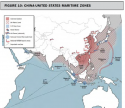
Here's an older map from the CBSA on the Western Pacific.

Basically Chinese bastions extend out 400km from mainland Chinese bases.
The logic is that airborne AWACs has a radar horizon of 420km+.
And that land-based SAMs have a range of 400km.

So the Chinese bastions run along:

1. All of the Bohai Sea
2. All of the Yellow Sea to the coast of South Korea,
3. Half of the East China Sea, to the 400km midpoint from Shanghai to Kyushu
4. Covering all of Taiwan
5. Then from Hainan, to Woody Island and down to the 3 bases in the South China Seas.

These are low-risk and medium-risk areas for Chinese warships.
And the high-risk (no-mans land) area are further beyond.

CN-US.png
 

Tam

Brigadier
Registered Member
All these ship design features help with warships hiding yes.
But even the Zumwalt still looks like a fishing boat, as per the US Navy.
Surface ships will still be detected by airborne radars at long distances.

---

You're missing the point.

My exact words were:


We all know the oceans follow the Earth's curvature and impose a radar horizon. That is obvious.

It is the primary reason why aircraft are better at finding ships, because aircraft can fly high, and also cover long distances.

But in the real world, from the point of view of an airplane looking for enemy ships - the sea is essentially flat and featureless.
The ship has nowhere it can hide. It can look smaller with stealthy shaping, but it can't actually hide anywhere.

At the same time, if you detected a ship, how are you going to identify it? There is going to be plenty of ships in the ocean, by far, most of which are civilian and commercial. The Type 056A is a ship that is smaller than most ships in the ocean, and one that has a much lower radar return.

I should add that the kind of radar used for look down doesn't have the same range as the radar used for air to air detection.
 

Tam

Brigadier
Registered Member
Here's an older map from the CBSA on the Western Pacific.

Basically Chinese bastions extend out 400km from mainland Chinese bases.
The logic is that airborne AWACs has a radar horizon of 420km+.
And that land-based SAMs have a range of 400km.

So the Chinese bastions run along:

1. All of the Bohai Sea
2. All of the Yellow Sea to the coast of South Korea,
3. Half of the East China Sea, to the 400km midpoint from Shanghai to Kyushu
4. Covering all of Taiwan
5. Then from Hainan, to Woody Island and down to the 3 bases in the South China Seas.

These are low-risk and medium-risk areas for Chinese warships.
And the high-risk (no-mans land) area are further beyond.

View attachment 56740


The reason for the bastion areas is for the corvettes to protect the SSBNs. Not because you want to hide your ships.

Plus the idea that you think the Bohai Sea won't be attacked by US assets located in South Korea and Japan is ludicrisp.
 

AndrewS

Brigadier
Registered Member
At the same time, if you detected a ship, how are you going to identify it? There is going to be plenty of ships in the ocean, by far, most of which are civilian and commercial. The Type 056A is a ship that is smaller than most ships in the ocean, and one that has a much lower radar return.

I should add that the kind of radar used for look down doesn't have the same range as the radar used for air to air detection.

You're arguing that a Type-56 is useful as a fleet screen and in identifying/engaging enemy ships.

But a Type-56 has the same problem as an airplane in classifying what kind of ship they've found on radar.
Thinking about it, the Type-56 is worse at doing this.

An airplane can fly closer in, identify the target, then disengage safely underneath the radar/visual horizon.
Or an airplane could fly at really high altitude instead.

What can a Type-56 do except sail in closer?
But a Type-56 barely has any air defence against incoming missiles.

---
A useful fleet screen in a high-risk environment needs a decent air defence system. Which basically means a Type-54A Frigate or larger.

So can you see how a Type-56 Corvette has no place as a fleet screen in a high-risk environment.
 

AndrewS

Brigadier
Registered Member
The reason for the bastion areas is for the corvettes to protect the SSBNs. Not because you want to hide your ships.

No, you're missing the point.

Bastions are simply areas where you have air and maritime superiority, which means you can safely operate airplanes and ships in relative safety.

Requirement
1. China needs to defend its coast because:
1a. There are densely populated cities all along the coastline
1b. It protects military facilities along the coast, and also in the interior.
1c. The Chinese interior is also densely populated
How this happens
2. Land-based SAMs (with a range of 400km) can effectively hide in the urban terrain of mainland China.
3. These land-based SAMs can work with AWACs aircraft overhead, which also have a radar horizon of 420km
4. Chinese fighter CAP will also be operating in this area.
5. It means enemy aircraft and ships will be at very high risk if they try to operate within 400km of the Chinese coast.
6. And the waters next to the Chinese coast benefit from being under this protective umbrella.

What it means

It means Chinese bastions basically run the entire length of the Chinese coast, from the frozen North to the tropical South of China.
Then onwards to Woody Island and to the bases in the South China Seas.

So Chinese bastions cover every seaport in China, and connect to the sealanes in South East Asia and beyond.

So Chinese cargo ships aren't hiding in Chinese bastions as you put it. The entire Chinese coastline is a bastion. The Bohai Sea *bastion* in the North just happens to be surrounded by Chinese coastline.

Cargo ships will still be serving every Chinese seaport and connecting to the global trading system via neutral countries in the South China Seas.
But they will still need ASW escorts (like the Type-56 and Type-54A) against submarines

Plus the idea that you think the Bohai Sea won't be attacked by US assets located in South Korea and Japan is ludicrisp.

The Bohai Sea is a SECONDARY theatre.
Will the US have many spare assets, given that the critical action will be elsewhere?
Plus will South Korea and Japan actually declare war on China?

Japan is 1000km from the Bohai Sea. They would have to cross South Korea and pass the Shandong peninsula to get to the Bohai Sea.
What are the odds of US airplanes and ships making it through?

And if South Korea declares war, Seoul accounts for half of the population.
But Seoul is only 400km from Shandong province and 350km from Dandong city.
This means Seoul is already within the A2AD bubble created by Chinese AWACs and SAMs.

And we haven't even looked at Chinese forces forward deploying into North Korea yet.
If China and South Korea are at war, then North Korea needs China to win such a conflict.

And given enough time, it would be conceivable for the Chinese Army to conquer South Korea.
 

Bhurki

Junior Member
Registered Member
The fact of the matter is that info about a 6-7k ton frigate equipped with 346 based S band, 055 like X band, VDS+TAS, UVLS (no ajk bs) is due since the start of 2020. If we don't know a thing about it by now means the first ship won't hit the water until 2022.

052d was a safe bet employing newer radar design for a single purpose (S band for search) while hedging against potential failures of complete aesa based sensor suite by using a slew of older dome radars like 366, 364 etc.

055 departed from this idea, and is now underway in testing and proving the capabilities and shortfalls that this approach may entail.

What this means is that there maybe enough data now to prove the usability of modular, interchangable and easily upgradable sensors (like rma assemblies on AMDR) and employing them fleetwide among all the new classes clearing path for next gen heavy frigate/light destroyer.
 
Top