@tphuang Sir China act as a stabilizing force in Scarborough shoal ,let me explained there are permanent rotation of Chinese Coast Guard vessel inside the lagoon, policing it and there is no fishing inside, only within the periphery did the Chinese allowed the Filipinos, the Vietnamese , the Taiwanese and the Chinese fisherman to fish. In this way the fish stock will not be depleted, unlike before the Filipino fisherman had less catch due to large fishing boat from Taiwan ravaging the shoal. It was not reported in MSM cause it's contrary to their narrative of bad China. What you hear from western MSM is about the Chinese Coast Guard harassing Filipino fisherman who want to enter the shoal and make trouble, those weren't true fisherman but paid hack, its all propaganda design to embarrass Duterte for being soft to China.Well, I don't see fishing grounds at Scarborough Shoal as a big loss, so....
If the concern is just economical, then that definitely should not stop an agreement.
If you can make an agreement that works, then do it. It's not like China will have a hard time enforcing agreement once it can push America out of the region.
You are using an out of date browser. It may not display this or other websites correctly.
You should upgrade or use an alternative browser.
You should upgrade or use an alternative browser.
China's SCS Strategy Thread
- Thread starter lilzz
- Start date
It is nice to know. But how many of your countrymen actually understand about this and/or agree with this?@tphuang Sir China act as a stabilizing force in Scarborough shoal ,let me explained there are permanent rotation of Chinese Coast Guard vessel inside the lagoon, policing it and there is no fishing inside, only within the periphery did the Chinese allowed the Filipinos, the Vietnamese , the Taiwanese and the Chinese fisherman to fish. In this way the fish stock will not be depleted, unlike before the Filipino fisherman had less catch due to large fishing boat from Taiwan ravaging the shoal. It was not reported in MSM cause it's contrary to their narrative of bad China. What you hear from western MSM is about the Chinese Coast Guard harassing Filipino fisherman who want to enter the shoal and make trouble, those weren't true fisherman but paid hack, its all propaganda design to embarrass Duterte for being soft to China.
only those fisherman and telling the truth had serious consequences, they were dupe to sign a petition against China and the Phil government by a lawyer named Chel Diokno, I think @Bellum_Romanum is very familiar with this man...lol And an embarrassment to my Alma Mater DLSU. He want to provoke war between China and the Philippines, a US paid hack, his father Jose Diokno a Filipino nationalist will be rolling in his grave, cursing his son for smearing the family name...lolIt is nice to know. But how many of your countrymen actually understand about this and/or agree with this?
Aug 3, 2019 — LAWYERS Jose Manuel Diokno and Andre Palacios claimed they were counsels for 20 Palawan and Zambales fishermen when they filed a writ of ...
Jul 11, 2019 — De La Salle University law dean Chel Diokno, who was grilled by justices about the issue during the hearing, said the development was suspicious ...
Missing:
Jul 26, 2019 — The false report copy-pasted as its content a July 11 Inquirer.net report about 22 fishermen from Palawan and Zambales who claimed they were ...
Missing:
Jul 12, 2019 — However, Diokno insisted that he had spoken to the fishermen. Furthermore, he objected to how government lawyers had secretly approached the the ...
Missing:
Jul 11, 2019 — In affidavits obtained by CNN Philippines, 22 fisherfolk from Palawan and Zambales denied signing a case against the government. Roberto Asiado, ...
Missing:
Last edited:
You are correct.Sir nobody want an intruder to camp in your lawn especially a neighbor, Its better for China to concentrate on Taiwan cause it provide the same strategic posture as you mentioned. IF Taiwan is taken, the Philippine is less strategic cause it provide an ideal staging point for the Chinese to threaten the American position in Asia.
China having control over Taiwan would provide Beijing with an undisputable control in the East China Sea, truly breaching the First Island Chain, and allowing PLAN warships and submarines to have unfettered access to the open Pacific.
However, and firstly, consider this map:
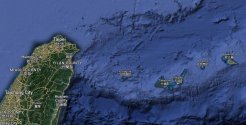
In particular, take note of the islands of Yonaguni and Ishigaki.
Ishigaki Island is a mere 240 kilometers east of Taiwan. Yonaguni Island, meanwhile, is a mere 120 kilometers east of Taiwan.
Next, let me introduce these two planes - Lockheed Martin P-3 Orion and Kawasaki P-1 maritime patrol aircrafts of the JMSDF.
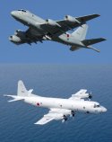
JMSDF currently has 68 P-3s and 23 P-1s, whereby the P-1s would gradually replace the P-3s in the JMSDF. And what are these maritime patrol aircrafts are for? Simple - they are meant for patrolling the open ocean, searching for enemy warships, engage in S&R operations, and most importantly - hunting for enemy submarines.
I highlight the last term in particular is because the JMSDF is merely an extension of the prowess of the USN in the Western Pacific. Furthermore, I think we can all agree that the USN currently is the best and most experienced in anti-submarine warfare (ASW) operations. While I do not know the current capability and sophistication of the PLAN in terms of ASW warfare, but I think that the PLAN still have some room to catch up with their American and Japanese peers.
So why do I brought this up?
It is because both the Ishigaki and Yonaguni Islands have at least one runway each. And at least the runway on Ishigaki can actually host P-3s and P-1s. Enlongating the runway on Yonaguni in order to host P-3s and P-1s wouldn't be difficult either.
Say, sometime in the future when China is able to reunify Taiwan under direct Beijing control. Consider if both the US and Japan did not get involved in the hypothetical reunification war of Taiwan, which means that the military capability and firepower of the US and Japan in the Western Pacific would not be affected at all, if not increased due to China's stronger presence in the Western Pacific.
Besides, the PLAN would certainly base some of their warships in Taiwan after the reunification of the island is complete. Here's the map of the ROCN bases across Taiwan.
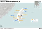
Notice that there are two naval bases that are the closest to Ishigaki and Yonaguni - Suao and Keelung. In fact, Keelung is at present the largest ROCN naval base in Taiwan. Therefore, it is safe to assume that the heavier and more powerful PLAN warships would be stationed there.
Coincidentally speaking, those two PLAN bases would also be very exposed to reconnaisance and monitoring operations of the JMSDF based from Ishigaki and Yonaguni, if not the USN from Naha. The JMSDF P-3s and P-1s can very easily fly around the eastern and northern coastlines of Taiwan, meaning that any movements by the PLAN would be tracked and followed by the JMSDF and USN, just like in the one map (out of many) below.
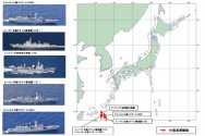
By having Ishigaki and Yonaguni located closer to PLAN bases in Taiwan would also significantly reduces the flight time spent by JMSDF and USN maritime patrol aircrafts flying to and from their bases and the designated patrol areas, meaning that there would be more time for them to loiter around plus monitoring and hunting PLAN warships operating from their bases in northern and eastern Taiwan.
Furthermore, the reason why I highlighted the term ASW above - is mainly because China has the Jianggezhuang Naval Base located in Qingdao, which is one of the only two PLAN naval bases that are hosting nuclear-powered ballistic missile submarines (SSBNs).
In order for the PLAN SSBN and SSNs based in Qingdao to access the open Pacific, the shortest route would be to cross the Miyako Strait, which is sandwiched between the Okinawa and Miyako Islands to the north and south. Needless to say, the US and Japan certainly will conduct intensive maritime patrols along the strait, especially if the geopolitical situation in the Western Pacific becomes even tenser than it is now.
Such scenario signficantly raises the possibility for any of the Qingdao-based 094s, 094As and 096s to be detected once they cross the Miyako Strait. And once any of those subs are detected, it would not be difficult to follow and keep track of them by maritime patrol and ASW units. In case a major hostility between China and the US breaks out, the first priority for the JMSDF and USN would be to hunt down theose PLAN SSBNs and sink them ASAP before those SSBNs could launch their nuclear-tipped SLBMs against the continental US.
Moreover, the PLAN SSNs based in Qingdao, i.e. 093s, 093As and 095s would also have to access the open Pacific in order to effectively interdict and intercept warships and military convoys that are coming from Japan, Guam, Hawaii and the continental US to relief and support their forces that are fighting in the Western Pacific, thanks to their unlimited range compared to conventionally-powered submarines. Similarly, going through the Miyako Strait would also have the same implications as described just above.
And how is this related to the Philippines?
Take a look at this map.
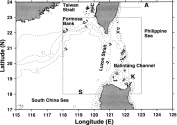
That's right - the Luzon Strait, sandwiched between Taiwan and the Luzon Island of the Philippines to the north and south.
So why did I believe that apart from focusing on Taiwan, China would need to get the Philippines as close to China's side as best as possible?
Because securing the Luzon Strait is very crucial for safeguarding the passage of the PLAN SSBNs and SSNs from the China Seas into the Philippine Sea, and hence, the open Pacific.
Please refer to the illustrated map below:
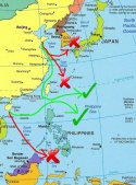
In the north:
The Miyako and Tsushima Straits can be easily blocked off by the USN, JMSDF and ROKN.
In the south:
1. The Sulu Sea and its respective straits are not just further away from both Jianggezhuang and Qingdao, but it also has more islands and islets that would increase the risks of underwater collisions like what happened to USS Connecticut last October;
2. Australia with their RAN warships and ASW units would also be close by to block it as well; and
3. Sailing SSBNs and SSNs through the South China Sea would risk violating the ZOPFAN and SEANWFZ of ASEAN, risking disapproval from fellow ASEAN members that borders the South China Sea, which could work against China when dealing with the South China Sea disputes later on.
(both of the routes are marked in red arrows and red crosses)
That leaves only the Luzon Strait as the safest and most secure route for not just PLAN warships, but also their SSBNs and SSNs to access the open Pacific from the China Seas. This would significantly alter the balance of power in the Western Pacific, because the PLAN could easily sail around the Pacific Ocean, challenge the hegemonic presence of the USN head on, and not being constrained by the narrows of the First Island Chain. (route marked by green arrows and green ticks)
Securing the Luzon Strait would also provide a blind spot for the PLAN to sneak their SSBNs and SSNs into the open Pacific, as any ASW units of the JMSDF, USN and RAN would have to fly further away from their air bases to reach their designated patrol areas, therefore reducing the amount of time that could be spent patrolling the area and hunting for PLAN nuclear-powered submarines entering the open Pacific.
All of these - while also avoiding the risk of violating the ZOPFAN and SEANWFZ of ASEAN.
Furthermore, if China is capable of making the Philippines into one of her closest security partners in the Western Pacific, the possibility of the Philippines hosting USN and RAN units (ASW in particular) can also be significantly reduced, thus providing China a larger space to breathe for her PLAN warships and nuclear-powered submarine to access the open Pacific freely and without restriction.
And personally, I believe that this is very crucial for not just securing China's own future in the Pacific Theater, but also working towards gradually pushing the US back to the Eastern Pacific - Militarily, influence, or both.
(I think I spent like 2 hours writing this, so please enjoy this wall of words lol)
Last edited:
You are correct.
China having control over Taiwan would provide Beijing with an undisputable control in the East China Sea, truly breaching the First Island Chain, and allowing PLAN warships and submarines to have unfettered access to the open Pacific.
However, and firstly, consider this map:
View attachment 91708
In particular, take note of the islands of Yonaguni and Ishigaki.
Ishigaki Island is a mere 240 kilometers east of Taiwan. Yonaguni Island, meanwhile, is a mere 120 kilometers east of Taiwan.
Next, let me introduce these two planes - Lockheed Martin P-3 Orion and Kawasaki P-1 maritime patrol aircrafts of the JMSDF.
View attachment 91713
JMSDF currently has 68 P-3s and 23 P-1s, whereby the P-1s would gradually replace the P-3s in the JMSDF. And what are these maritime patrol aircrafts are for? Simple - they are meant for patrolling the open ocean, searching for enemy warships, engage in S&R operations, and most importantly - hunting for enemy submarines.
I highlight the last term in particular is because the JMSDF is merely an extension of the prowess of the USN in the Western Pacific. Furthermore, I think we can all agree that the USN currently is the best and most experienced in anti-submarine warfare (ASW) operations. While I do not know the current capability and sophistication of the PLAN in terms of ASW warfare, but I think that the PLAN still have some room to catch up with their American and Japanese peers.
So why do I brought this up?
It is because both the Ishigaki and Yonaguni Islands have at least one runway each. And at least the runway on Ishigaki can actually host P-3s and P-1s. Enlongating the runway on Yonaguni in order to host P-3s and P-1s wouldn't be difficult either.
Say, sometime in the future when China is able to reunify Taiwan under direct Beijing control. Consider if both the US and Japan did not get involved in the hypothetical reunification war of Taiwan, which means that the military capability and firepower of the US and Japan in the Western Pacific would not be affected at all, if not increased due to China's stronger presence in the Western Pacific.
Besides, the PLAN would certainly base some of their warships in Taiwan after the reunification of the island is complete. Here's the map of the ROCN bases across Taiwan.
View attachment 91711
Notice that there are two naval bases that are the closest to Ishigaki and Yonaguni - Suao and Keelung. In fact, Keelung is at present the largest ROCN naval base in Taiwan. Therefore, it is safe to assume that the heavier and more powerful PLAN warships would be stationed there.
Coincidentally speaking, those two PLAN bases would also be very exposed to reconnaisance and monitoring operations of the JMSDF based from Ishigaki and Yonaguni, if not the USN from Naha. The JMSDF P-3s and P-1s can very easily fly around the eastern and northern coastlines of Taiwan, meaning that any movements by the PLAN would be tracked and followed by the JMSDF and USN, just like in the one map (out of many) below.
View attachment 91712
By having Ishigaki and Yonaguni located closer to PLAN bases in Taiwan would also significantly reduces the flight time spent by JMSDF and USN maritime patrol aircrafts flying to and from their bases and the designated patrol areas, meaning that there would be more time for them to loiter around plus monitoring and hunting PLAN warships operating from their bases in northern and eastern Taiwan.
Furthermore, the reason why I highlighted the term ASW above - is mainly because China has the Jianggezhuang Naval Base located in Qingdao, which is one of the only two PLAN naval bases that are hosting nuclear-powered ballistic missile submarines (SSBNs).
In order for the PLAN SSBN and SSNs based in Qingdao to access the open Pacific, the shortest route would be to cross the Miyako Strait, which is sandwiched between the Okinawa and Miyako Islands to the north and south. Needless to say, the US and Japan certainly will conduct intensive maritime patrols along the strait, especially if the geopolitical situation in the Western Pacific becomes even tenser than it is now.
Such scenario signficantly raises the possibility for any of the Qingdao-based 094s, 094As and 096s to be detected once they cross the Miyako Strait. And once any of those subs are detected, it would not be difficult to follow and keep track of them by maritime patrol and ASW units. In case a major hostility between China and the US breaks out, the first priority for the JMSDF and USN would be to hunt down theose PLAN SSBNs and sink them ASAP before those SSBNs could launch their nuclear-tipped SLBMs against the continental US.
Moreover, the PLAN SSNs based in Qingdao, i.e. 093s, 093As and 095s would also have to access the open Pacific in order to effectively interdict and intercept warships and military convoys that are coming from Japan, Guam, Hawaii and the continental US to relief and support their forces that are fighting in the Western Pacific, thanks to their unlimited range compared to conventionally-powered submarines. Similarly, going through the Miyako Strait would also have the same implications as described just above.
And how is this related to the Philippines?
Take a look at this map.
View attachment 91714
That's right - the Luzon Strait, sandwiched between Taiwan and the Luzon Island of the Philippines to the north and south.
So why did I believe that apart from focusing on Taiwan, China would need to get the Philippines as close to China's side as best as possible?
Because securing the Luzon Strait is very crucial for safeguarding the passage of the PLAN SSBNs and SSNs from the China Seas into the Philippine Sea, and hence, the open Pacific.
Please refer to the illustrated map below:
View attachment 91722
In the north:
The Miyako and Tsushima Straits can be easily blocked off by the USN, JMSDF and ROKN.
In the south:
1. The Sulu Sea and its respective straits are not just further away from both Jianggezhuang and Qingdao, but it also has more islands and islets that would increase the risks of underwater collisions like what happened to USS Connecticut last October;
2. Australia with their RAN warships and ASW units would also be close by to block it as well; and
3. Sailing SSBNs and SSNs through the South China Sea would risk violating the ZOPFAN and SEANWFZ of ASEAN, risking disapproval from fellow ASEAN members that borders the South China Sea, which could work against China when dealing with the South China Sea disputes later on.
(both of the routes are marked in red arrows and red crosses)
That leaves only the Luzon Strait as the safest and most secure route for not just PLAN warships, but also their SSBNs and SSNs to access the open Pacific from the China Seas. This would significantly alter the balance of power in the Western Pacific, because the PLAN could easily sail around the Pacific Ocean, challenge the hegemonic presence of the USN head on, and not being constrained by the narrows of the First Island Chain. (route marked by green arrows and green ticks)
Securing the Luzon Strait would also provide a blind spot for the PLAN to sneak their SSBNs and SSNs into the open Pacific, as any ASW units of the JMSDF, USN and RAN would have to fly further away from their air bases to reach their designated patrol areas, therefore reducing the amount of time that could be spent patrolling the area and hunting for PLAN nuclear-powered submarines entering the open Pacific.
All of these - while also avoiding the risk of violating the ZOPFAN and SEANWFZ of ASEAN.
Furthermore, if China is capable of making the Philippines into one of her closest security partners in the Western Pacific, the possibility of the Philippines hosting USN and RAN units (ASW in particular) can also be significantly reduced, thus providing China a larger space to breathe for her PLAN warships and nuclear-powered submarine to access the open Pacific freely and without restriction.
And personally, I believe that this is very crucial for not just securing China's own future in the Pacific Theater, but also working towards gradually pushing the US back to the Eastern Pacific - Militarily, influence, or both.
I think you are mostly right here. A friendly and allied Philippines will make China's live a lot easier. But I do need to point out one other benefit and that's related to Japan.
I'm going to write something up on this, but the likely "base" or "forward point" or "semi-permanent structure" that China will have through Cambodia (and possibly Myanmar) coupled with the fully expanded SCS islands and packing 2 or 3 carriers in the region means China can effectively control Malacca straits in another 10 years. So where else can Japan get its energy and trade? Well the ships can take the long way around Indonesia and East of Philippines. Well, if PLAN can operate at total peace in Philippines Seas, China blocks off the long route around Malacca for shipping to Japan.
As I said when it comes to SCS, China needs to be the closest friend to either Indonesia or Philippines, but preferably both.
the next 10 years will be some of the most tense years for PLA. There are significant reasons to be generous in coming to deal with Philippines and Indonesia to have greater operational freedom in the region.
If people are concerned about China losing an island in SCS. Think about this. Would you rather lose a small island and nearby fishing ground or lose a major war?
Eh, the PLAN can very much get some base build around the eastern side of the southern part of the island as well though.You are correct.
China having control over Taiwan would provide Beijing with an undisputable control in the East China Sea, truly breaching the First Island Chain, and allowing PLAN warships and submarines to have unfettered access to the open Pacific.
.....
Besides, the PLAN would certainly base some of their warships in Taiwan after the reunification of the island is complete. Here's the map of the ROCN bases across Taiwan.
View attachment 91711
Notice that there are two naval bases that are the closest to Ishigaki and Yonaguni - Suao and Keelung. In fact, Keelung is at present the largest ROCN naval base in Taiwan. Therefore, it is safe to assume that the heavier and more powerful PLAN warships would be stationed there.
Although, the PLA surely would base in currently already estabilished ROC bases, they could also set up new (and put some down).
If China needs a neutral Philippines to win a war against the US then the PLA is useless and may as well as sit down for 50 more years of development and stop wasting our time following its newsWould you rather lose a small island and nearby fishing ground or lose a major war?
Putting the above hypothetical aside, the margins involved in such a war are so big for China to get involved that a neutral Philippines amounts to basically nothing.
So for the question about the Island:
No
If they want to fish, they can fish, I don't care. It is strategically irrelevant. If they want sovereignty of the island, they must first become strategically independent (Russia style) and then we can talk if you want
Thanks. Great analysis.@tphuang Sir China act as a stabilizing force in Scarborough shoal ,let me explained there are permanent rotation of Chinese Coast Guard vessel inside the lagoon, policing it and there is no fishing inside, only within the periphery did the Chinese allowed the Filipinos, the Vietnamese , the Taiwanese and the Chinese fisherman to fish. In this way the fish stock will not be depleted, unlike before the Filipino fisherman had less catch due to large fishing boat from Taiwan ravaging the shoal. It was not reported in MSM cause it's contrary to their narrative of bad China. What you hear from western MSM is about the Chinese Coast Guard harassing Filipino fisherman who want to enter the shoal and make trouble, those weren't true fisherman but paid hack, its all propaganda design to embarrass Duterte for being soft to China.
@tphuang Sir regarding SCS its game over, China won and those FON is just an irritant like a fly. Why Japan is embarrassing themselves overseas, cause they know Taiwan IF the Chinese really want to can easily retaken. What holding the Chinese back, aside from having the same ethnicity, they see Japan in a decade will be weakened considerably economically, thus defeating an enemy without fighting. An armed race is Japan worse nightmare , with American focus on Ukraine where is the promise of China Pivot that they sign on. The geopolitical dynamics is changing so fast that Japan can't keep pace, they're thinking by 2030 the Chinese giant will overwhelm them. Right now the Joint Russia and China FON around the Japanese island is making the Japanese jumpy, the only consolation is Kishida is part of the cool kids and is serving sake with Modi in tow...lolI think you are mostly right here. A friendly and allied Philippines will make China's live a lot easier. But I do need to point out one other benefit and that's related to Japan.
I'm going to write something up on this, but the likely "base" or "forward point" or "semi-permanent structure" that China will have through Cambodia (and possibly Myanmar) coupled with the fully expanded SCS islands and packing 2 or 3 carriers in the region means China can effectively control Malacca straits in another 10 years. So where else can Japan get its energy and trade? Well the ships can take the long way around Indonesia and East of Philippines. Well, if PLAN can operate at total peace in Philippines Seas, China blocks off the long route around Malacca for shipping to Japan.
As I said when it comes to SCS, China needs to be the closest friend to either Indonesia or Philippines, but preferably both.
the next 10 years will be some of the most tense years for PLA. There are significant reasons to be generous in coming to deal with Philippines and Indonesia to have greater operational freedom in the region.
If people are concerned about China losing an island in SCS. Think about this. Would you rather lose a small island and nearby fishing ground or lose a major war?
Wonderful foresights. I think China has been thinking of this for a long while. Japan will collapse under its own debts especially it has to pay protection money to a gangster!@tphuang Sir regarding SCS its game over, China won and those FON is just an irritant like a fly. Why Japan is embarrassing themselves overseas, cause they know Taiwan IF the Chinese really want to can easily retaken. What holding the Chinese back, aside from having the same ethnicity, they see Japan in a decade will be weakened considerably economically, thus defeating an enemy without fighting. An armed race is Japan worse nightmare , with American focus on Ukraine where is the promise of China Pivot that they sign on. The geopolitical dynamics is changing so fast that Japan can't keep pace, they're thinking by 2030 the Chinese giant will overwhelm them. Right now the Joint Russia and China FON around the Japanese island is making the Japanese jumpy, the only consolation is Kishida is part of the cool kids and is serving sake with Modi in tow...l
