PLAN SCS Bases/Islands/Vessels (Not a Strategy Page)

kwaigonegin

Colonel
I think the cost of a nuclear facility and lack of natural protection for the facility makes it not as enticing. Not sure what the wind potential is in those areas but a wind farm right off those waters would probably be the most self sustaining and capable of generating 20 MW.

Yup.. A couple of super efficient windmills and some high density solar panels should adequately run a place like that. Maybe an oil tank and batteries for emergency backup generators and redundancy.
 

joshuatree

Captain
Taiwan is also upgrading its island in the Spratlys with facilities to support Navy and air force assets - though of course it does not receive the kind of criticism China does, while laying claim to the same area that China does.

Please, Log in or Register to view URLs content!

Be interesting if they did land reclamation to enlarge Taiping.


Yup.. A couple of super efficient windmills and some high density solar panels should adequately run a place like that. Maybe an oil tank and batteries for emergency backup generators and redundancy.

I like that combo though I add a few more windmills that can be installed in the waters right off the island and save the precious rooftop space for solar water heating panels. Even if only available during the day, hot water is a luxury that would be appreciated by those out there.

The generator and battery backups I would say should be strictly for only essential loads.
 

AeroEngineer

Junior Member
The
Please, Log in or Register to view URLs content!
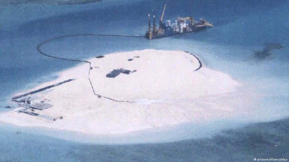
has a photo it says is of the Chinese construction at Johnson South Reef.

0,,17633757_403,00.jpg


Any idea of how big it is right now?


According to CJDBY, the Chinese plan to build an artificial island on Johnson South Rif, eventually turn it into an island around 2.5 KM^2, about 250 meters wide and 1000 meters long. This will allow it to take off and land Y-20, and other jet fighters.

China also plan to install a small naval base on the island too.

The island is schedule to be completed by 2020 !!
 

A.Man

Major
According to CJDBY, the Chinese plan to build an artificial island on Johnson South Rif, eventually turn it into an island around 2.5 KM^2, about 250 meters wide and 1000 meters long. This will allow it to take off and land Y-20, and other jet fighters.

China also plan to install a small naval base on the island too.

The island is schedule to be completed by 2020 !!

My friend, 250 x 1000 = 250000 m^2 = .25 km ^ 2
 

duncanidaho

Junior Member
According to CJDBY, the Chinese plan to build an artificial island on Johnson South Rif, eventually turn it into an island around 2.5 KM^2, about 250 meters wide and 1000 meters long. This will allow it to take off and land Y-20, and other jet fighters.

China also plan to install a small naval base on the island too.

The island is schedule to be completed by 2020 !!

Shouldn't it be 2500m X 1000m?

1000m is definitely too short for a landingstrip.
 

joshuatree

Captain
According to CJDBY, the Chinese plan to build an artificial island on Johnson South Rif, eventually turn it into an island around 2.5 KM^2, about 250 meters wide and 1000 meters long. This will allow it to take off and land Y-20, and other jet fighters.

China also plan to install a small naval base on the island too.

The island is schedule to be completed by 2020 !!

I have to agree with duncanidaho on the runway length, how can a Y-20 land with 1000 meters? The runway at Woody/Yongxing is 2700 meters. Unless the reclamation continues, if there is to be a runway, it's of limited use. Not sure what length is required for patrol planes. Vietnamese Su27s & Su30s patrol from the mainland. So if Chinese J-11s can make a refuel here, their range and loiter time can be extended.

The deeper harbor and port facilities are the actual important pieces of this project in my opinion. It would allow a naval facility to tender and resupply vessels without them having to head all the way back to Woody, allowing ships to be on duty far longer and with less breaks in coverage.
 

Jeff Head

General
Registered Member
I think this is the latest picture...at least the latest one I had seen...from later in March 2014. (I believe the other was from February 2014):


2014-03-mabini.jpg


I believe 2,500m x 1,000m is more in line with what is being accomplished there.
 

Geographer

Junior Member
Can someone explain to me some of the engineering behind land reclamation? Dumping sand on a reef doesn't seem very durable because the ocean currents and waves will quickly erode it, just like beaches erode. Wouldn't it be better to build the whole island out of concrete, or at least dump some big rocks down and then pour concrete on top of them?
 

joshuatree

Captain
Can someone explain to me some of the engineering behind land reclamation? Dumping sand on a reef doesn't seem very durable because the ocean currents and waves will quickly erode it, just like beaches erode. Wouldn't it be better to build the whole island out of concrete, or at least dump some big rocks down and then pour concrete on top of them?

Using material (sand) from the dredging is the most economical and efficient way of supplying the "dirt" to make the land. But you are right about erosion. It's possible that piles may have been driven and we don't have pics of that. But there appears to be a concrete wall being constructed to retain the sand and prevent erosion.

Saw some articles speculating land reclamation to be planned for Fiery Cross as well.
 
Top