PLAN SCS Bases/Islands/Vessels (Not a Strategy Page)

Geographer

Junior Member
I'm confused about the layout of Sanya's mountain submarine base.
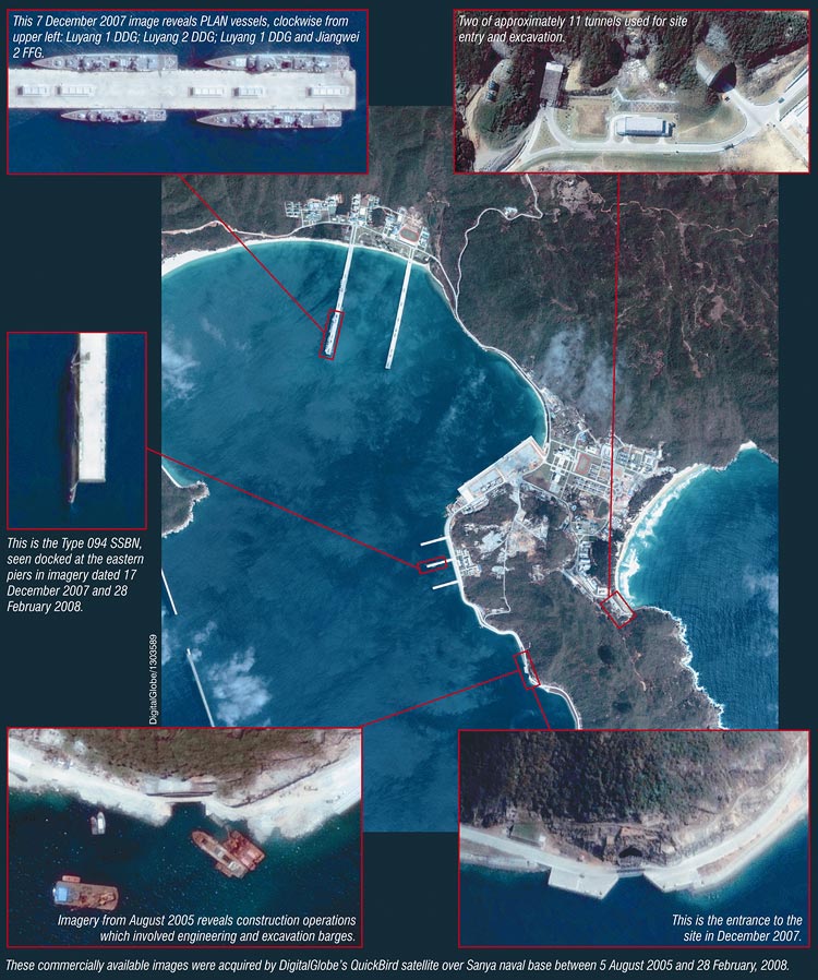
sanya8.jpg


This compilation shows the entrance to the underground submarine base in the bottom right. But the entire entrance is above the waterline, so how can subs get in? Even if you assume the picture was taken at low-tide, high-tide would mean the whole road is flooded, which does not make sense. No satellite images have ever shown the road underwater so we have to assume high-tide would still not allow a submarine to enter the tunnel. This picture shows the road crossing beneath the tunnel entrance. Therefore the tunnel must be above the high-tide line.

1zwhjbt.jpg
 

delft

Brigadier
I would expect the road to be build at a sufficient height about water to allow subs to pass underneath
 

Maggern

Junior Member
I would expect the road to be build at a sufficient height about water to allow subs to pass underneath

Indeed. If the sun is at right angle, it would not be remotely possible to assess the correct height of features in this photo. I don't think it's impossible to expect the entrance to extend sufficiently below the waterline, while the road traverses a bridge that is sufficiently above the entrance.
 

no_name

Colonel
@#91

You were probably thinking that the round tunnel (which appears to be completely above water) is the entrance for the submarine. In reality that is probably another entrance (for maintenance, supplies or what not) and the actual entrance for the sub is below it, under the water.

edit: Infact if you look at the last pic that you posted, the top tunnel has clearly been sealed. Therefore it may have served the construction purpose of removing dug materials.
 
Last edited:

plawolf

Lieutenant General
I'd expect it to be some sort of gate structure that can be lowered to allow subs to come and go but keep unwanted snoopers out.

If they just left the entrance open to the sea, I am sure certain countries would try to sneak something/someone in under water to have a look see.
 

Geographer

Junior Member
So you all are saying there is probably a large opening below the tunnel we see? The dark blue water indicates it is deep enough. But it just seems strange to have that large opening at ground level and another one beneath it. There are several tunnel entrances on the opposite side of the hill through which to move people and supplies to the concealed submarines.
 

plawolf

Lieutenant General
No, I am saying the causeway running across the mouth of the tunnel could easily be moveable, and if so, would slip down under the water to give enough clearance for subs to pass. Once the subs are out/in, the door slides back up so nothing can sneak in underwater.

It would just be a big concrete slab moving up and down on runners. Hardly cutting edge tech. The only twist is they put some tarmac on top and made it a bridge of sorts to allow vehicles to cross when the door isn't being used.
 

Spartan95

Junior Member
This compilation shows the entrance to the underground submarine base in the bottom right. But the entire entrance is above the waterline, so how can subs get in? Even if you assume the picture was taken at low-tide, high-tide would mean the whole road is flooded, which does not make sense. No satellite images have ever shown the road underwater so we have to assume high-tide would still not allow a submarine to enter the tunnel. This picture shows the road crossing beneath the tunnel entrance. Therefore the tunnel must be above the high-tide line.

Personally, I very much doubt that is an entrance to a protected submarine base.

If you look at the composite photo and compare the size of the small vessels near the tunnel, it is quite clear that the width of the tunnel isn't particularly wide. Based on that, I very much doubt that a regular conventional submarine will be able to fit in there.

Secondly, given the location of the tunnel relative to the rest of the coastline, it is quite clear that the current (flow of water) at the entrance to the tunnel will be perpendicular to the direction of the tunnel. Hence, even if a submarine can fit in the tunnel, trying to get 1 in will be an extreme exercise in accident prevention. Every single time.

If I'm not mistaken, the idea of the tunnel being an entrance to a protected submarine base was initially proposed by Jane's. And we all know how "accurate" Jane's is with regards to PLA affairs.

So, this leads us to the question of what exactly is that tunnel for? At the bottom left of the composite photo, barges are seen near the tunnel. My guess is that the barges are there to remove the material from the hollowing out of the hillock. In other words, a protected cavern is being built at that location. Since multiple tunnels are visible from the photo, it would indicate the construction of a large protected complex under the hillock. To me, that points to 2 possibilities: a protected headquarters for the South Sea Fleet, or protected ammunition storage (for all the weapons that the South Sea Fleet uses, possibly including nuclear weapons) or both (HQ + ammo storage).
 

no_name

Colonel
Secondly, given the location of the tunnel relative to the rest of the coastline, it is quite clear that the current (flow of water) at the entrance to the tunnel will be perpendicular to the direction of the tunnel. Hence, even if a submarine can fit in the tunnel, trying to get 1 in will be an extreme exercise in accident prevention. Every single time.

It should be ok if the harbour is partly walled:

newbase.png
 

Spartan95

Junior Member
It should be ok if the harbour is partly walled:

That depends on what kind of wall that is.

There are essentially 2 types that I'm aware of; full length wall that acts as a breakwater, or surface barrier on columns that allows currents to pass underneath. Can't really tell which type from overhead photos alone.
 
Top