Ladakh Flash Point

Status
Not open for further replies.

Xizor

Captain
Registered Member
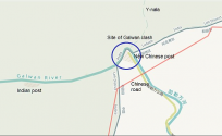
Found this image on DFI of India's new permanent camp in the Galwan valley, about 1 km from the 1962 lac, which runs just behind the river bend(historical pp14).
Clarify.

Where, point it out on a map to make things clear. Whose camp, location zoomed out, date of the image etc.
 

Xizor

Captain
Registered Member
How can there be a buffer zone when disengagement is not complete? But fair enough, you have the right to draw your own conclusions. And in Hot Springs, the area where the camps are facing off is disputed, China claims about 1-2km past that to the confluence of the two rivers, which according to shukla's diagram, is roughly where pp 15 is. I know I have posted this image before, but I think it makes more sense now.
And India claims entirety of Aksai Chin.

We were talking about LAC of India and now you are talking about China's claims.

Now I'll talk about India's claims. I think it's fair game?

If the satellite images are upto date then

1. Hot Springs (PP15)

Chinese camps are 1.5 to 2 km within LAC of India. Exact nature of buffer zone and patrolling unknown.

2. Gogra ( PP17A to PP19)

A buffer zone has been likely created somewhere between the PP17A to PP19, within what is India's LAC. No satellite images that shows activity in that gap.
@twineedle You seem to have disagreement about the above two points. Make your assertions clear. What do you think happened in these regions if the "conclusions" I drew, exercising my "rights" are wrong?

You never get to the point.
 
Last edited:

Xizor

Captain
Registered Member
Found this image on DFI of India's new permanent camp in the Galwan valley, about 1 km from the 1962 lac, which runs just behind the river bend(historical pp14).
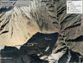
I'm posting the zoomed out image.
2.25 km from the new LAC (bend) of India.

Annotation 2021-03-20 230504.jpg
 

twineedle

Junior Member
Registered Member
I'm posting the zoomed out image.
2.25 km from the new LAC (bend) of India.

View attachment 70155
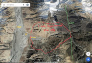
That map lines up pretty well with this annotated one, which uses US Office of the Geographer data based on historical Indian claims. Also I thought goggle earth is unreliable? Because google doesn't show any "new" lac, is shows the same one as it did before 2020.
1616280382469.png

And I guess I could be mistaken, but I think the map looks more like it is from the bend right to the east of where you marked, which is about 1.25 km from the historic Indian claim, marked on google.
 

Xizor

Captain
Registered Member
That map lines up pretty well with this annotated one, which uses US Office of the Geographer data based on historical Indian claims. Also I thought goggle earth is unreliable? Because google doesn't show any "new" lac, is shows the same one as it did before 2020.
View attachment 70156

And I guess I could be mistaken, but I think the map looks more like it is from the bend right to the east of where you marked, which is about 1.25 km from the historic Indian claim, marked on google.
It is. Discussing where the LAC is drawn by Google (or borders determined by them) is not of interest. Did I do that? No. I didn't. That Google earth Map was taken as is.

What's more of interest to me is to show that Indian posts are x distance away from the new LAC (just by the bend).

The Indian posts here are 2.25 km from the bend.
Annotation 2021-03-20 230504.jpg

Bold 2 : ???

The discussion here is about the distance of the posts from the bend. I have pinpointed the posts exactly with the Lat, lon coordinates.

1.25 km from the historic Indian claim?
The Historic Indian claim lies far into the bend. (old LAC as per RJS)

If including that you get 2.25 + 1.25 = some 3.5 km.
 
Last edited:

twineedle

Junior Member
Registered Member
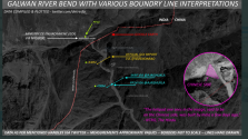
i am curious if there are any historical Indian maps with that claim line. The only one I could find was the one in Shukla's blog, and we know Shukla's track record has not been perfect to say the least. All maps I could find show the lac*or at least the Indian claim, China's claim is far to the west) exactly where marked on google maps and in that US Office of the geographer map. Even the map Lt. Gen. Panag drew, roughly mathces up(in fact his is actually slightly west). Obviously, we now now he was wrong about PLA capturing the circled area, but that is beyond the point.
1616282669830.png
 

Xizor

Captain
Registered Member
i am curious if there are any historical Indian maps with that claim line. The only one I could find was the one in Shukla's blog, and we know Shukla's track record has not been perfect to say the least. All maps I could find show the lac*or at least the Indian claim, China's claim is far to the west) exactly where marked on google maps and in that US Office of the geographer map. Even the map Lt. Gen. Panag drew, roughly mathces up(in fact his is actually slightly west). Obviously, we now now he was wrong about PLA capturing the circled area, but that is beyond the point.
View attachment 70158
Bold 1:Speak for yourself.
I think he is 'relatively' better compared to the pro-Modi party cronies you prefer to highlight.

Now that we have got a clearer idea about the distance of the posts from the bend (Not 1 km but 2.25km) have we moved to discussing LAC line?
-- - - - - - -
Whatever you drew (Green line). Doesn't make any sense. Are you saying that the bend LAC had been the traditional LAC and that RJS and Ajai Shukla are wrong?
If so, I think enough has been discussed already.

604a94b4458a5437057320af65d0654e09a13efd.png
Refer previous posts.


Its true, I've read China has started making fresh claims to the entire Galwan River (till the mouth). Maybe the Indian actions forced China to do that? Idk.
 

Xizor

Captain
Registered Member
i am curious if there are any historical Indian maps with that claim line.
Yes. I have the same doubts. We are on the same page here.

I'm curious too. But here, the claim made by that patrol Troop commander can be given much heft. He is willing to go on record and is sure about his assertions.

If we get an old map or preferably the word of another Patrol Troop leader like him that challenges the assertions ... his words will be eroded in credibility.

Until then... It is what it is.
 

twineedle

Junior Member
Registered Member
Bold 1:Speak for yourself.
I think he is 'relatively' better compared to the pro-Modi party cronies you prefer to highlight.

Now that we have got a clearer idea about the distance of the posts from the bend (Not 1 km but 2.25km) have we moved to discussing LAC line?
-- - - - - - -
Whatever you drew (Green line). Doesn't make any sense. Are you saying that the bend LAC had been the traditional LAC and that RJS and Ajai Shukla are wrong?
If so, I think enough has been discussed already.

View attachment 70159
Refer previous posts.


Its true, I've read China has started making fresh claims to the entire Galwan River (till the mouth). Maybe the Indian actions forced China to do that? Idk.
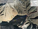
I am simply posting Lt. Gen Panag for the sake of comparison. I have no idea which "Modi cronies" you are referring to, but Panag sure is not one of them. Just read his analyses. And btw, I do not think Panag's map is correct. The historic lac has always been the red line, where China reached in 1962, as shown in historical Indian and US documents. China of course claimed west and still claimed west.

And btw, I think the location is to the east of where you marked, though I could be wrong. It is hard to tell exactly where it is, since the river in the DFI image is obviously much higher than in the current google images.
 
Status
Not open for further replies.
Top