Hendrik_2000
Lieutenant General
@Jura From the link that you provide Seem like the Indian does not have justification to intervene in this dispute. And they make the same mistake like they did in 62 by interpreting the boundary unilaterally. some people just never learn the lesson of history and they will suffer the same like before. Deja Vu. They can crow all they want while they can but they will gnashing their teeth for the next 100 years
I rest my case I can't change your pov which is clearly taking Indian side but it doesn't really matter
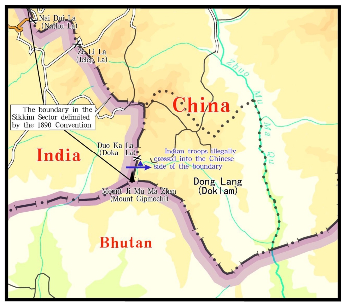
Another thing in doklam there is treaty that delineate where the boundary is but in SCS there is no such thing so it is not the same argument. the Indian show they trespass
Is India, then, interpreting the 1890 Convention unilaterally? If so, then it is a dangerous game. Something similar happened when the MEA in 1959 “interpreted” the McMahon Line which, as per treaty, terminated on the Bhutan border at 27°44′30″ N. But when Indian patrols went there, they found that this was not the highest ridge of the watershed – that was at Thag La ridge, some 4 kms north of where McMahon had drawn the line on the map. The Indian side decided on its own that Thag La ridge was the boundary, and the Indian Army was asked to throw the Chinese off that ridge in an ill-considered operation that triggered the disastrous war of 1962.
In Part I of the Henderson Brooks report on page 54, section 33 noted “DHOLA post was established NORTH of the McMAHON Line as shown in maps prior to October/November 1962 edition. It is believed the old edition was given to the Chinese by our External Affairs Ministry to indicate the McMAHON Line. It is learnt we tried to clarify the error in our maps, but the Chinese did not accept our contention.”
(My comment) No justification and as usual they bring in SCS which is again false since UNLCOS has no jurisdiction over territory dispute. SCS is more like free for all where every one grab while they can. A road doesn't change status. If china bring missile it change the status. Just because you don't like your neighbor action doesn't give you the right to enter his property. It is called trespassing
While the Indians have been assertive in protecting interests that they consider vital to their security posture in the region, they remain cagey when it comes to the cartographic game. According to the Survey of India website, the map of Sikkim is .
There is a bottom line here, though not a very comfortable one. Which is that international agreements are merely worth the paper they are written on, unless there is some interest amongst the parties concerned to uphold them. The Chinese are upset at India’s attitude towards the 1890 Convention. But they should introspect about their own attitude to the UNCLOS arbitration award on the South China Sea in 2016 which they have spurned, just because it did not suit their interests.
Last edited:


