Sure, but submarine military parity would be one very important change.
You seem to have missed everything I wrote in my last post.
Sure, but submarine military parity would be one very important change.
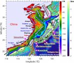
It's not ideal, but until they can more adequately protect 094s, they will have to be moving in that area in order to cover most of CONUS. I guess if they are able to take out military bases in Japan early on in a war, then they can theoretically operate out of Sea of Japan. Western part of Phillipines Sea is also possible. I don't know if they have enough sensors in there to really protect a 094 doing patrols out there.陈虎, a former senior colonel in the PLA said Bohai and Yellow Sea is unsuitable for ballistic submarines because shockwaves from nuclear explosions travel much further in shallow waters.
He's implying the US can nuke the entire sea to take out some subs? Some BS if I've ever heard it...陈虎, a former senior colonel in the PLA said Bohai and Yellow Sea is unsuitable for ballistic submarines because shockwaves from nuclear explosions travel much further in shallow waters.
I think I should stress this one: The important thing regarding SSBNs is that their fundemental value of deterrence lies in them being able to move around silently and avoiding detection & tracking by adversarial forces.You see US subs roaming the world, though. Why can the US track Chinese subs in the Gulf of Mexico but China can't track US subs, in, for example, the East China Sea?
For deployment in the Pacific Ocean, or just along the Chinese coastline/within the First Island Chain?Forget SSBN, slowly moving UUVs with SLBM are what you need in such a situation.
I will leave out his other comments, but basically he is saying that Chinese medium/long range ballistic missile technology has advanced so much (in this 4th generation) that they have no problem exporting it to the Saudis something like DF-21C这次被美国披露直接给了固体弹道导弹组装工厂。型号估计是DF21C。应该卖不少钱,石油人民币又进了一步![[酷] [酷]](https://face.t.sinajs.cn/t4/appstyle/expression/ext/normal/c4/2018new_ku_org.png)
靠着固体燃料自动罐装技术、高超音速乘波体技术、廉价导引头技术。中国实现了乘波体高超DF17的大批量生产。产量直接上四位数,单价仅一千多万RMB。比美国最新的战斧式巡航导弹还便宜![[阴险] [阴险]](https://face.t.sinajs.cn/t4/appstyle/expression/ext/normal/9e/2018new_yinxian_org.png)
DF27今年也已出现,未来中远程乘波体弹道导弹也将大批量生产。目前固体燃料自动灌装技术已在中远程弹道导弹上应用![[哈哈] [哈哈]](https://face.t.sinajs.cn/t4/appstyle/expression/ext/normal/8f/2018new_haha_org.png)
世界领先的第四代弹道导弹技术成熟,是中国放心输出中程乃至中远程弹道导弹技术的前提。
Speaking of which, how has the development and testing work of this space-based underwater submarine detection system by China going since 2018? Any updates?In fact, 200m depth is necessary for completely avoiding satellite tracking considering wake flow.
For Bohai, we can forget wake flow just because optical image can clearly show the dark silhouette of submarines. On the other hand, rudders would be totally useless in so shallow depth: if you have 13m diameter body and 20m water, there’s only 3.5m water between surface/bottom and you! Any little tiny interference or mistakes make you hit the bottom or break surface. Any sober captain won’t drive faster than 5knot there. Why SSBN?First of all, I never suggested that they should operate 094s at 20 m depth. Although I wouldn't preclude option of moving into such depth. Secondly, there is so much activity going on in Bohai/Yellow sea. Idea that satellite can track 094s moving around slowly using wake flow seems far fetched (even if they are operating pretty shallow). Even finding a carrier in the middle of the Ocean with satellites is not easy. You want satellite to find a couple of 094s that are moving within first island chain between East, Yellow and Bohai sea by wake flow?
Keep in mind that diesel subs operate closer to the surface and MPAs are still normally only able to spot them when they are snorkeling or surfacing or using MAD/sonobuoys.
Indeed.For Bohai, we can forget wake flow just because optical image can clearly show the dark silhouette of submarines. On the other hand, rudders would be totally useless in so shallow depth: if you have 13m diameter body and 20m water, there’s only 3.5m water between surface/bottom and you! Any little tiny interference or mistakes make you hit the bottom or break surface. Any sober captain won’t drive faster than 5knot there. Why SSBN?
SSK is a different story, their diameter are much smaller, nevertheless they rarely operate in Bohai. For operating in yellow water and ECS, being tracked by chance is not a big deal since SSKs are expendable in nature.

Many papers about using SAR/IR satellites to detect wake flow and how such a constellation can build a statistic map for a large region or even the whole ocean, while many of those papers imply SBWASS has this capabilities.Speaking of which, how has the development and testing work of this space-based underwater submarine detection system by China going since 2018? Any updates?
