China Ballistic Missiles and Nuclear Arms Thread

Status
Not open for further replies.

FairAndUnbiased

Brigadier
Registered Member
I have no doubt that the PLARF land-based ICBMs will continue to be an integral part of China's nuclear deterrence, but one cannot deny that sea-based deterrence is, pound-for-pound, the most sought-after and capable arm of the nuclear triad, especially when US satellites are almost certainly keeping close watch on all suspected Chinese missile sites.

The 300 silos may signal an increase to their land-based platforms but that in an of itself isn't any indication that China has shifted its priority from SSBNs to land-based ICBMs. The shell game theory is interesting, because if it turns out to be true, this could actually signal a reduction in their land-based ICBM arsenal.
SSBNs are great if your subs have a large bastion. Russia has entire Arctic and the Sea of Okhostk. These are remote waters with 1 side open, 1 side controlled fully by Russia. US has entire Pacific east of Hawaii, entire Atlantic west of Iceland and Gulf of Mexico. China has Yellow Sea which is good but small, South China Sea which is far less safe because it's not open, 3/4 sides aren't controlled by China and are crowded. East China Sea is utterly useless.

Why shell game? What do you think the breakdown is in cost between basing, delivery vehicle and warhead? You don't know. But we do know these facts: US and Russia built 2000+ per year in the 1960's and even North Korea, Pakistan and India have them, so how expensive can they be?

The 300 silos are a clear signal: do not doubt the existence of the deterrence. In the past 5 years there was a very dangerous trend of think tankers drinking their own koolaid, actually believing that China only had 200-300 warheads, and openly musing (with government permission of course) that maybe a disarming first strike, or escalation in case of losing conventionally, isn't such a bad idea.
 

SEAD

Junior Member
Registered Member
SSBNs are great if your subs have a large bastion. Russia has entire Arctic and the Sea of Okhostk. These are remote waters with 1 side open, 1 side controlled fully by Russia. US has entire Pacific east of Hawaii, entire Atlantic west of Iceland and Gulf of Mexico. China has Yellow Sea which is good but small, South China Sea which is far less safe because it's not open, 3/4 sides aren't controlled by China and are crowded. East China Sea is utterly useless.

Why shell game? What do you think the breakdown is in cost between basing, delivery vehicle and warhead? You don't know. But we do know these facts: US and Russia built 2000+ per year in the 1960's and even North Korea, Pakistan and India have them, so how expensive can they be?

The 300 silos are a clear signal: do not doubt the existence of the deterrence. In the past 5 years there was a very dangerous trend of think tankers drinking their own koolaid, actually believing that China only had 200-300 warheads, and openly musing (with government permission of course) that maybe a disarming first strike, or escalation in case of losing conventionally, isn't such a bad idea.
A warhead is cheaper than a tank or even a soldier, indeed.

A W80-1 in 1990 costs 720,000 dollars.
 

Kalec

Junior Member
Registered Member
While SSBNs and SLBMs are technically the most survivable form of second strike deterrence, for the PLA, the survivability and weight placed on SSBNs depends not only on the capability of SSBNs and SLBMs themselves but also the regional geography and disposition of outside military forces forward deployed in the region.

Which is to say -- SSBNs and SLBMs once mature and competitive will be a major component of the PLA's nuclear deterrent, but even then, it is likely that a major land based deterrence will be as significant or perhaps even more significant than the underwater sea based deterrent.
I have no doubt that the PLARF land-based ICBMs will continue to be an integral part of China's nuclear deterrence, but one cannot deny that sea-based deterrence is, pound-for-pound, the most sought-after and capable arm of the nuclear triad, especially when US satellites are almost certainly keeping close watch on all suspected Chinese missile sites.

The 300 silos may signal an increase to their land-based platforms but that in an of itself isn't any indication that China has shifted its priority from SSBNs to land-based ICBMs. The shell game theory is interesting, because if it turns out to be true, this could actually signal a reduction in their land-based ICBM arsenal.
The main obstacle for a sea-based priority on nuclear deterrent, is geography and the massive fleet of US SSN.

PLA's SLBMs put high priority on range instead of yield, because JL-3 is presumably designed to launched from SCS. It is very likely JL-3 can only carry ONE warhead, and theoretically no more than 3 warheads with low yield. It translates to 12 warheads with 500 kt- 1mt or 36 warheads with 150kt. Meanwhile one peacekeeper alike silo-based missile alone can carry ten 300kt - 500kt warheads and much cheaper than SSBN.

Generally based on US data since we don't have data on Chinese procurement, 1 SSBN can buy at least 4 Peacekeeper silos. It cost US $20 billion in Peacekeeper program (100 silos), which equates to approximately $60 billion now. In comparison with UK SSBN program, 4 Vanguards cost £20 billion ($24 billion) in today value on procurement. Ofc peacekeeper can use existing Minuteman silos and China needs to build new ones to accommodate. In this case, I will double the cost to try to estimate how much it costs for silo deployment in China -- $120 billion. It doesn't reflect the true cost because China has far cheaper capability to build silos and doesn't take in account for PPP adjustment, but it is very obvious that silos is best investment China can do and provide excellent deterrence.
 

FairAndUnbiased

Brigadier
Registered Member
The main obstacle for a sea-based priority on nuclear deterrent, is geography and the massive fleet of US SSN.

PLA's SLBMs put high priority on range instead of yield, because JL-3 is presumably designed to launched from SCS. It is very likely JL-3 can only carry ONE warhead, and theoretically no more than 3 warheads with low yield. It translates to 12 warheads with 500 kt- 1mt or 36 warheads with 150kt. Meanwhile one peacekeeper alike silo-based missile alone can carry ten 300kt - 500kt warheads and much cheaper than SSBN.

Generally based on US data since we don't have data on Chinese procurement, 1 SSBN can buy at least 4 Peacekeeper silos. It cost US $20 billion in Peacekeeper program (100 silos), which equates to approximately $60 billion now. In comparison with UK SSBN program, 4 Vanguards cost £20 billion ($24 billion) in today value on procurement. Ofc peacekeeper can use existing Minuteman silos and China needs to build new ones to accommodate. In this case, I will double the cost to try to estimate how much it costs for silo deployment in China -- $120 billion. It doesn't reflect the true cost because China has far cheaper capability to build silos and doesn't take in account for PPP adjustment, but it is very obvious that silos is best investment China can do and provide excellent deterrence.
what do you think is the breakdown in cost between TEL vs. silo?
 

Tempest

New Member
Registered Member
That's something I can comment on. No. It takes the same energy loss to deorbit an object as it did to put the object there in orbit, minus drag.

Ordinary ICBM warheads are not in orbit. Their trajectory intersects with the earth. An orbital warhead must change it's trajectory from one not intersecting earth to one that does. That requires an engine.

So instead of launching just a warhead you must launch an engine and fuel (1000 kg for even a small engine, no fuel) with sufficient delta V to deorbit the warhead, a positioning system, and the warhead itself.

Much less energy is required for a non orbital trajectory than an orbital one. Much less energy is required for an orbital trajectory than one that goes to orbit then deorbits controllably.
I would contest this. You say "minus drag" but that's a bit like saying you can bake a cake with an ice cube, minus the heat. Aerobraking is a principal component of de-orbiting any spacecraft, and it's the reason that it takes an extra gigantic fuel tank and two extra solid rocket boosters to get a Space Shuttle to orbit, but only about 300m/s of dV in the OMS to get back home. Orbital bombardment systems do have a myriad of issues, and are *generally* not a very efficient system of deterrence, but the sheer kinematics are not really one of them.
 

Tempest

New Member
Registered Member
your enemy can jam you twice a week to let you don’t trust your alarm system.

2nd stage verification needs time, while the anti-stealth radar provides not-so-enough warning time even with 1 stage verification(that’s what I mean by “those radar cannot detect targets in decent distance for any strategic warning system”)

Could you explain what do you mean by “simultaneously refutes the hypothesis that the silos houses FOBS”? I have explained my idea clearly enough.
I can't say I know exactly what scenario you are envisioning, but system-wide deception jamming of modern, high gain, frequency agile AESAs such as LPAR that make up a non-insignificant portion of the systems (and an even higher portion of overall sensor footprint) employed by the PLA in the BMEW role... is a monstrous task. Not only would this require a huge jammer ERP to overwhelm such a massive, high gain, and EP-wrapped target, but it would also have to be done from a platform (or operational system, depending on scope) with the EW suite necessary to keep up with LPAR's frequency hopping, and generate many false returns per EA platform, and those false returns would have to mimic either/both ballistic contacts as well as VLO strategic airpower. I'm not sure how much you've read as far as modern EMSO and the physical constraints on it, but this is quite outside the realm of feasibility. Even to intermittently create false returns on a handful of systems would require a very sizeable number of EA sorties to be generated and employed along probable threat axes (after all, a Trident II return coming from Xinjiang would be highly peculiar, whereas a B-21 ingressing from the north/northeast is very reasonable), which presents a problem in that most of these BMEWRs, due to these probably threat axes and targets, are not exactly sticking their neck out. I would be quite surprised if the US could, ostensibly in peacetime if your suggestion of jamming every couple of weeks is to imply deception about capability rather than degradation of capability of their early warning network, but especially in wartime - generate sorties inland enough to conduct EA missions against the LPAR in Xinjiang lol. I personally just find this idea entirely imprudent, confusing in purpose, and almost undoubtedly unfeasible on a sheer logistical basis.

You say "anti-stealth radar provides not-so-enough warning time even with 1 stage verification." I'm curious where you get this information from. Assuming an ongoing conventional war escalates into a nuclear war, Everything about a thousand nautical miles East of Beijing will be positively blanketed in sensors, and can be regarded as essentially PLA stomping ground, barring an unlikely Russia-esque overestimation of PLA equipment or some loony tunes scenario in which the US has the entirety of INDOPACCOM and PACAF up and at 'em as the conflict's starting pistol fires. Furthermore, even if the PLA is rolled back to defending its own and near-periphery airspace, there is still a very modern, sizable counter-air complex in place to prosecute even LO/VLO targets (cruise missiles, even Tomahawk, have a nasty small RCS; but developments in AEW&C, dense coverage and sizeable proliferation of modern AESA EWR/FCRs, and ample GBAA and modern aircraft all make them very viable targets regardless). Furthermore, strategic aviation has been the second-stringer in the US's triad for quite some time now. Even assuming the PLA *didn't* have the ability to simply surveil US Airbases (notably, ones hosting STRATCOM toys), Trident IIs have historically been envisioned as the ones kicking the door down in a first strike, while aircraft and land based ICBMs contribute much of the sheer volume of munitions needed to generate an effective counterforce/countervalue salvo.

I'm surprised you think so poorly of the PLA, while maintaining such strikingly surface level knowledge of US Nuclear CONOPs haha
 

Hendrik_2000

Lieutenant General
There is no dedicated AShBM So I will put it here China has completed the Yaogan series of surveillance satellite network according to Henri K It was decades long effort Nowhere to hide for CVBG. Another thing China has experimented with socalled agile satellite who can change their orbit. Now where is our friend SEAD who said china need thousand of satellite to cover certain area. Or China DOES Not has the necessary surveillance system?. The original is in French so Google translation is here
Please, Log in or Register to view URLs content!

The Yaogan-30 constellation has already been the subject of two
Please, Log in or Register to view URLs content!
, but this should be the last: following the launch of the seventh trio of satellites, the constellation now has six evenly distributed orbital planes. She has thus reached her full capacity and final form.

The six orbital planes of the constellation
Having only six orbital planes with seven launches might seem odd. As pointed out in a
Please, Log in or Register to view URLs content!
, the third and fourth launches injected their satellites into the same orbital plane, and created a "train" of five satellites that follow each other very closely. This makes it possible to have an extremely high revisit rate when this train passes over a region of interest.


A satellite out of service​

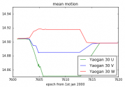
The other peculiarity of the constellation is that one of the satellites of the sixth group is out of service, or at least its propulsion system is: Yaogan 30T (international designator 2020-021C) is not correctly positioned in its orbital plane. Normally the three satellites in the same plane are phased at 120° from each other, to maximize constellation coverage. On the other hand, Yaogan 30T and 30S are currently very close to each other, which makes one of the two redundant.

The one with the problem is Yaogan 30T, as can be seen in this graph comparing the sixth group's orbital elements:
1651842175636.png
Evolution over time of the number of revolutions per day for the 6th group


The 30T satellite has not made any maneuvers since it has been in orbit, and therefore performs more revolutions per day around the Earth than the other two. This means that its position in the orbital plane is constantly changing, and the fact that it is currently near 30S is just a coincidence. He will move away from it over time.

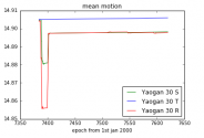
We can compare with what happens in the case of a group whose three satellites are perfectly functional, as is the case for the last launch:
1651842199241.png
Evolution over time of the number of revolutions per day for the 7th group


The satellites were launched together and therefore at the beginning the curves are confused. Then they used their thrusters to maneuver and each had a different number of revolutions per day. This allowed them to position themselves on a different sector of the orbit. They let this position drift until the 120° phase between the satellites was reached, then froze their orbital configuration by maneuvering again so that they all had exactly the same number of revolutions per day. This ensures that they stay synchronized in their orbit.

It is possible that China will eventually replace the satellite that is out of order, because it would improve the coverage offered by the constellation, making it more regular with fewer interruptions. This would be a good opportunity for one of China's new small launchers like the CZ-11 rocket, since a single Yaogan-30 type satellite represents a small payload.

Cover
Speaking of coverage, let's look at what the constellation can do. Given its inclination, it is optimized for observing the environment close to China, in particular the approaches to its Pacific coast. Taipei, the capital of Taiwan, is therefore a very representative area of interest, especially since the recent rearmament efforts of the Republic of China with the United States have heightened tensions in the region.

Based on the 3D models of the satellites broadcast by Chinese television, they do not appear to carry radar or imaging systems, so they are probably used for electronic intelligence, with perhaps a communication function as well. This kind of sensors generally need to see their target under an angle of incidence of at least 5°. Based on this assumption, we can calculate the coverage of Taipei over a 24-hour period:
1651842230503.png
In cyan, the coverage periods.


We see that the coverage is almost constant, with the longest interruption lasting around 30 minutes, and most interruptions lasting 10 minutes every half hour. The following video shows satellite positions and coverage opportunities (in the form of a purple link between the satellite and the ground):


Plans for the future​

This rate of revisiting is already the highest among all known constellations in China or elsewhere, but the middle country does not intend to stop there, as Academician Li Deren explains in a
Please, Log in or Register to view URLs content!
:

“The first step is to provide local (local) coverage from the South China Sea to the North China region . This requires about 20 remote sensing satellites and 1-3 communications satellites in geostationary orbit to achieve 15 minute temporal resolution. High-resolution target images and sub-meter navigation and positioning accuracy are sent to users' mobile phones and other intelligent terminals;

The second stage is the regional coverage of China and neighboring countries along the Belt and Road. This requires a hundred remote sensing satellites. Among them, half of the remote sensing satellites are optical satellites and the other half are radar satellites to guarantee the broadcasting of images day and night, plus 150 communication satellites;

The third step is global . To achieve a worldwide service, it is estimated that 200 remote sensing satellites and 300 communication satellites will be required. The service index is the time resolution of 5 minutes, that is, the required image target is found within 5 minutes, the resolution and navigation accuracy reach 0.5 m, and the time processing and communication in orbit is less than 1 minute before being delivered to the user's mobile phone. »


Yaogan-30 is the first stage, with 21 satellites optimized for the Chinese coastline. However, it does not reach a revisit every 15 minutes, so Mr. Deren may be talking about another constellation that will be launched in the near future. The use of geostationary satellites as relays, so as to minimize the latency of the system, can on the other hand already be implemented on Yaogan-30.

Li Deren also explains that future developments will combine the traditionally separate functions of communication, Earth observation and positioning into a single system, and data will be sent directly to end-users' phones to minimize latency and maximize their impact:


" The perceived data will be intelligently processed to provide users with the function of PNTRC, P representing the position, N the navigation route, T the time, R the image remote sensing [Remote sensing], and C the communication, it that is, this information can be sent to the receiving device in your hand. "

This plan looks like two drops of water to American ambitions to acquire a multi-layered military constellation to ensure communications, anti-ballistic missile warning and Earth observation. Given the extent of Chinese investment in the field, there is no doubt that they will manage to develop an equivalent system, and that therefore we have not finished hearing about large constellations of Chinese satellites.
 
Last edited:

clockwork

Junior Member
Registered Member
I think TELs in underground tunnels may be more survivable than SSBNs actually. Not sure how vulnerable to high-yield EPWs the whole tunnel system (e.g. "underground great wall") is, but I think it should be survivable. And you can dig many hidden exits so the US doesn't know where the launchers will pop up and fire from so they can't "seal them in" by destroying all of those. It's basically a way to ensure your missiles can't be destroyed at all.
 

escobar

Brigadier
There is no dedicated AShBM So I will put it here China has completed the Yaogan series of surveillance satellite network according to Henri K It was decades long effort Nowhere to hide for CVBG. Another thing China has experimented with socalled agile satellite who can change their orbit. Now where is our friend SEAD who said china need thousand of satellite to cover certain area. Or China DOES Not has the necessary surveillance system?. The original is in French so Google translation is here
Please, Log in or Register to view URLs content!

The Yaogan-30 constellation has already been the subject of two
Please, Log in or Register to view URLs content!
, but this should be the last: following the launch of the seventh trio of satellites, the constellation now has six evenly distributed orbital planes. She has thus reached her full capacity and final form.

The six orbital planes of the constellation
Having only six orbital planes with seven launches might seem odd. As pointed out in a
Please, Log in or Register to view URLs content!
, the third and fourth launches injected their satellites into the same orbital plane, and created a "train" of five satellites that follow each other very closely. This makes it possible to have an extremely high revisit rate when this train passes over a region of interest.


A satellite out of service​

The other peculiarity of the constellation is that one of the satellites of the sixth group is out of service, or at least its propulsion system is: Yaogan 30T (international designator 2020-021C) is not correctly positioned in its orbital plane. Normally the three satellites in the same plane are phased at 120° from each other, to maximize constellation coverage. On the other hand, Yaogan 30T and 30S are currently very close to each other, which makes one of the two redundant.

The one with the problem is Yaogan 30T, as can be seen in this graph comparing the sixth group's orbital elements:
View attachment 88381
Evolution over time of the number of revolutions per day for the 6th group


The 30T satellite has not made any maneuvers since it has been in orbit, and therefore performs more revolutions per day around the Earth than the other two. This means that its position in the orbital plane is constantly changing, and the fact that it is currently near 30S is just a coincidence. He will move away from it over time.

We can compare with what happens in the case of a group whose three satellites are perfectly functional, as is the case for the last launch:
View attachment 88382
Evolution over time of the number of revolutions per day for the 7th group


The satellites were launched together and therefore at the beginning the curves are confused. Then they used their thrusters to maneuver and each had a different number of revolutions per day. This allowed them to position themselves on a different sector of the orbit. They let this position drift until the 120° phase between the satellites was reached, then froze their orbital configuration by maneuvering again so that they all had exactly the same number of revolutions per day. This ensures that they stay synchronized in their orbit.

It is possible that China will eventually replace the satellite that is out of order, because it would improve the coverage offered by the constellation, making it more regular with fewer interruptions. This would be a good opportunity for one of China's new small launchers like the CZ-11 rocket, since a single Yaogan-30 type satellite represents a small payload.

Cover
Speaking of coverage, let's look at what the constellation can do. Given its inclination, it is optimized for observing the environment close to China, in particular the approaches to its Pacific coast. Taipei, the capital of Taiwan, is therefore a very representative area of interest, especially since the recent rearmament efforts of the Republic of China with the United States have heightened tensions in the region.

Based on the 3D models of the satellites broadcast by Chinese television, they do not appear to carry radar or imaging systems, so they are probably used for electronic intelligence, with perhaps a communication function as well. This kind of sensors generally need to see their target under an angle of incidence of at least 5°. Based on this assumption, we can calculate the coverage of Taipei over a 24-hour period:
View attachment 88383
In cyan, the coverage periods.


We see that the coverage is almost constant, with the longest interruption lasting around 30 minutes, and most interruptions lasting 10 minutes every half hour. The following video shows satellite positions and coverage opportunities (in the form of a purple link between the satellite and the ground):


Plans for the future​

This rate of revisiting is already the highest among all known constellations in China or elsewhere, but the middle country does not intend to stop there, as Academician Li Deren explains in a
Please, Log in or Register to view URLs content!
:

“The first step is to provide local (local) coverage from the South China Sea to the North China region . This requires about 20 remote sensing satellites and 1-3 communications satellites in geostationary orbit to achieve 15 minute temporal resolution. High-resolution target images and sub-meter navigation and positioning accuracy are sent to users' mobile phones and other intelligent terminals;

The second stage is the regional coverage of China and neighboring countries along the Belt and Road. This requires a hundred remote sensing satellites. Among them, half of the remote sensing satellites are optical satellites and the other half are radar satellites to guarantee the broadcasting of images day and night, plus 150 communication satellites;

The third step is global . To achieve a worldwide service, it is estimated that 200 remote sensing satellites and 300 communication satellites will be required. The service index is the time resolution of 5 minutes, that is, the required image target is found within 5 minutes, the resolution and navigation accuracy reach 0.5 m, and the time processing and communication in orbit is less than 1 minute before being delivered to the user's mobile phone. »


Yaogan-30 is the first stage, with 21 satellites optimized for the Chinese coastline. However, it does not reach a revisit every 15 minutes, so Mr. Deren may be talking about another constellation that will be launched in the near future. The use of geostationary satellites as relays, so as to minimize the latency of the system, can on the other hand already be implemented on Yaogan-30.

Li Deren also explains that future developments will combine the traditionally separate functions of communication, Earth observation and positioning into a single system, and data will be sent directly to end-users' phones to minimize latency and maximize their impact:


" The perceived data will be intelligently processed to provide users with the function of PNTRC, P representing the position, N the navigation route, T the time, R the image remote sensing [Remote sensing], and C the communication, it that is, this information can be sent to the receiving device in your hand. "

This plan looks like two drops of water to American ambitions to acquire a multi-layered military constellation to ensure communications, anti-ballistic missile warning and Earth observation. Given the extent of Chinese investment in the field, there is no doubt that they will manage to develop an equivalent system, and that therefore we have not finished hearing about large constellations of Chinese satellites.
 
Status
Not open for further replies.
Top