Does China currently have a modern, supersonic training jet? How long would it take China to create such a jet, if necessary?At this point the PLA has two priorities - modernizing its training system...
The main training aircraft capable of supersonic speed is the completely obsolete J-7 which has unwieldy aerodynamics being derived from the flying coffin (MiG-21). MiG-21 requires good piloting skill to be flown competently in combat. It is a horrible plane to learn your chops if you are moving to a FBW relaxed stability machine like J-11 or J-10. This essentially requires re-training of basic habits. If you learn to fly on a subsonic jet like JL-8 which has a comfortable speed of about 700-800km/h you lack basic skills for supersonic flight which is over 1200km/h and much more dangerous because the forces and reaction times changes are not linear but geometric...
Other than that larger numbers of modern, supersonic trainer jets and tankers are the immediate priority for PLAAF in the upcoming decade. 40 supersonic trainers a year are more important than 40 new 4th gen fighters a year because they allow PLAAF to maintain pilot numbers and quality.
You are using an out of date browser. It may not display this or other websites correctly.
You should upgrade or use an alternative browser.
You should upgrade or use an alternative browser.
Air Division, Regiments, ... Bases, Brigades, etc
- Thread starter Raven
- Start date
antiterror13
Brigadier
Does China currently have a modern, supersonic training jet? How long would it take China to create such a jet, if necessary?
JL-10 has been around for long time
Does China currently have a modern, supersonic training jet? How long would it take China to create such a jet, if necessary?
JL-10 was introduced in 2010. JL-9 which is a high transonic trainer with supersonic potential if not already a low supersonic jet - has been around since 2001. Trainers do not require advanced combat systems or engines so their production is less challenging. China could have been making them for years. So why weren't they?
Because in my view the problem isn't the jets but the instructors.
First of all instructors are pilots who have shown to possess specific skills in particular patience, social perception and good communication. The best instructor is in many ways the opposite of your best fighter pilot. In combat you gain advantage by correctly balancing on the edge between reckless and calculated. Calculated recklessnes you might say. The good instructor is all about cultivating meticulous groundwork while you are the candidate so that you can be reckless while remaining in control as a pilot. It is all about the right habits.
Psychological studies have shown that pilots in general but fighter pilots in particular tend to be individualistic and competitive and those are the wrong traits for an instructor. And of course the instructor needs to be a competent pilot at least. They don't need to be the very best but they have to be good. So selecting the right pool of instructors from the pool of pilots is difficult because it's like trying to start a fire with buckets of water. This is also why not many countries have comprehensive training systems for their air forces. In Europe many countries use allied facilities to train and obviously the US provides the most extensive infrastructure and support - with strings attached obviously. That's because it is not easy to build an institution that serves another institution while being completely different from it. It takes time and effort and the more candidates the better.
Secondly if you have a small number of modern fighters you want every single of your best pilots flying them to maximize your combat potential. China had half of the air force flying J-7 and J-8 until just over a decade ago. There was perhaps 400-500 J-10 and J-11s in service total at the time. This means that the need for retention of good pilots will get in the way of selecting good instructors. You need good instructors more in the long term but you need good pilots more in the short term.This means that instructors will be selected but it will be slower.
Thirdly if your plan is to train your pilots first on JL-9 or JL-10 and then move to J-10, J-11 or J-16 you need instructors who know both planes very well. This means that you can either produce more fighters and train pilots in the old system and reform it later, or you can divert scarce resources from fighters and pilots and build a better training system now. If China was in a secure political position the latter might be a better more rational choice. But if China considers itself to be vulnerable to pressure from the US it must prioritize immediate defensive potential.
A good instructor is the invisible backbone of every air force but there must be an air force first for the instructor to matter.
I do not pay as much attention to the news coming out of PLAAF as some people on this forum but I think that we see a trend shift right now - the production of new 4th gen fighters is slowing down which means that the fleet of fighters that you train for is stable. At the same time the production of new trainer jets seems to be slowly picking up.
And lets not forget that training pilots on JJ-7s is not wrong. It is just less efficient than the alternative in terms of time and resource expenditure. If the system works there's no rush to change it for the sake of changing it. Evolution is always better than revolution.
Hi MarkOz,Hello everyone.
I made a map illustrating the geographical distribution of combat and advanced training units of PLAAF and PLANAF listing their respective theatres of operation (W,N,C,E,S), brigade/regiment unit and the nominal aircraft type. I only listed combat aircraft and did not include training or auxiliary (AEW, EW, ELINT) aircraft.
I used scramble.nl for information including geographical locations. I'd like to ask the community for comments about any errors, missing information etc. Any and all constructive feedback is very welcome.
The colors indicate aircraft type - orange is for long range 5th gens, yellow is for long range 4th gens, red is for short range 4th gens, beige/tan is for legacy 3rd gens, dark blue is for frontline bombers and ground attack aircraft and light blue/teal is for strategic/long range bombers. The two green labels are test units from the CTO and the three white ones are bases for rotation of brigade detachments in the WTO.
The image has resolution of 2400x1500 pixels so it might be more convenient to open it in a separate tab. I am not sure yet how this website displays large res images.
View attachment 73108
Nice work. You are missing rotational bases at Hotan, Ngari Gunsa and Aksu in WTC, with Tashkurgan possibly becoming a rotational base in future. Scramble.nl are now saying 16th Brigade converted to J16 in March 21 and that the bases in southern Tibet are rotational units only, 98th and 99th based further East. That's all I've got for now.
And the Indian media are now claiming Shache airport is being developed as a fighter base.Hi MarkOz,
Nice work. You are missing rotational bases at Hotan, Ngari Gunsa and Aksu in WTC, with Tashkurgan possibly becoming a rotational base in future. Scramble.nl are now saying 16th Brigade converted to J16 in March 21 and that the bases in southern Tibet are rotational units only, 98th and 99th based further East. That's all I've got for now.
A few Google Earth updates
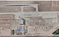
WTC Kashgar AB, notably 12 new style HASs
ETC Huzhou Changxing AB, home of 8th Brigade, notably 8 new style HASs, 3 new ammunition bunkers, a few hardened underground commanding posts
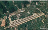
NTC Qiqihar AB, home of 3th Brigade, second runway almost finished, working on first runway started
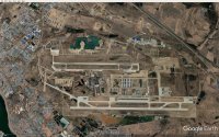
WTC Kashgar AB, notably 12 new style HASs

ETC Huzhou Changxing AB, home of 8th Brigade, notably 8 new style HASs, 3 new ammunition bunkers, a few hardened underground commanding posts

NTC Qiqihar AB, home of 3th Brigade, second runway almost finished, working on first runway started

J-16 Confirmed Bases: Rugao, Nanchang, Huizhou, Chongqing, Hotan, Chongming Island, Qiqihar
Unconfirmed Bases (100%): Pulandian, Hangzhou, Changsha, Changji, Weifang
J-20 Confirmed Bases: Wuhu, Anshan, Guilin, Korla, Zhengzhou, Changxing
Unconfirmed Bases (100%): Quzhou, Foshan, Luliang, Dazu, Yangcun, Jining
Unconfirmed Bases (100%): Pulandian, Hangzhou, Changsha, Changji, Weifang
J-20 Confirmed Bases: Wuhu, Anshan, Guilin, Korla, Zhengzhou, Changxing
Unconfirmed Bases (100%): Quzhou, Foshan, Luliang, Dazu, Yangcun, Jining
So what happens after 2030? The USAF, USNAF and allied air forces would have sufficient capability to overwhelm the PLAAF in any scenario?Keep in mind all that I said about readiness of reserve formations and the current state of F-35 fleet. When you include what the theoretical allies bring to the table - most notably Japan and Taiwan - it doesn't look so great in any scenario which involves aggressive containing of China. As long as China is on the defensive they are good until 2030 and that is completely leaving out the problem of logistics for F-35A which I indicated in the previous post. Unless the US finds a way to base F-35As in the Philippines or Indonesia they are stuck in Singapore and Japan which leaves them unable to contest China's power projection throughout most of South East Asia and Western Pacific since the limited number of aircraft carriers will wear out within a couple of years of intensive use while still providing only a small force of planes that currently have a technological edge over PLA.
Furthermore, how would the introduction of NGAD and F/A-XX change the equations in the Western Pacific? Since both of them are meant to have longer range and endurance in order to operate far from home bases, which is a prerequisite for any effective cross-Pacific operations.
Has China retired any of the older flankers like older Su-27 or J-11A?

