PLAN SCS Bases/Islands/Vessels (Not a Strategy Page)

visitant

New Member
Registered Member
Give me a break!

To me, Sinamilnews is only next to pure rumor and fake media.

Below are the links I can find on the (Philippines) ABS-CBN web site:
Please, Log in or Register to view URLs content!
(August 3)
Please, Log in or Register to view URLs content!
(August 4)
Related:
Please, Log in or Register to view URLs content!


There is NO such picture. Unless someone find it, this ps'd is purely a faked one on an exaggerated line ("菲律宾媒体'急切'装备中国造护卫舰的心情应该说可以理解"), with a very, very misguiding title, claiming originating from ABS-CBN.. ...

I am NOT getting any personal. Simply hope this help members stay alert about the credibility quoting from Sina news.
It's really not wise to trust google translation ...

PTV sorry for wrong photo in Philippine Navy report
Please, Log in or Register to view URLs content!

Warship.jpg
 

davidau

Senior Member
Registered Member
..the recently published China map [2018-9-1] showing national boundaries, including the original 9-dash lines + 1 more of eastern part to include Chinese Taiwan...

182927km5wsi5s5mmqmfll.jpg
 

antiterror13

Brigadier
Has there been any indication recently that China might start developing Scarborough Shoal in the near future? Cheers.

highly unlikely while Du30 still in power, but if the next Philippine president like Benigno Aquino III ... you'd bet China would do that in no time ... China is very much ready to start reclamating and developing Scarborough Shoal for sometime now
 

Hendrik_2000

Lieutenant General
Nansha weather stations start operating, to provide forecasts, warnings
By Liu Caiyu Source:Global Times Published: 2018/10/31 14:18:40
Please, Log in or Register to view URLs content!

53aec000-84cf-415f-a7da-900f54acb2fa.jpeg

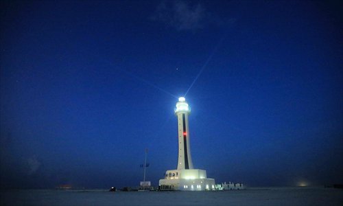
A photo taken on April 5 shows the lighthouse on the Nansha Islands' Zhubi Reef in the South China Sea. Photo: Xinhua

Meteorological stations in the Nansha Islands in the South China Sea officially began operating on Wednesday, which will help fishermen and ships receive accurate weather forecasts.

Meteorological facilities on Yongshu Reef, Zhubi Reef and Meiji Reef, including meteorological stations, aerological stations and weather radar, will offer round-the-clock weather forecasts, China Meteorological Administration announced on Wednesday.

Fishermen and passing vessels will be provided with weather warnings as the South China Sea frequently experiences typhoons, rainstorms and thick fog.

The administration said the facilities will help monitor real-time weather, offering weather forecasts and early warning for marine traffic, rescues and fishermen.


Global Times
 

Gloire_bb

Captain
Registered Member
28 Islands the Viets hold in the South China Sea. Just waiting for the Viets to do something stupid, then the PLAN SWEEP & Clean them out.
To be fair, Vietnam has significant capability to defend them in case of hostilities. They hold a huge grographical advantage, after all.
 

PiSigma

"the engineer"
To be fair, Vietnam has significant capability to defend them in case of hostilities. They hold a huge grographical advantage, after all.
Vietnam holds no geographical advantages vis-a-vis China. The distance to their holdings in the spratlys is basically the same, but they have worse ships. Also their most modern submarines (kilos) are also operated by China.

The problem Vietnam have right now is they have a lot of holdings, but many are like China's early 2000 stations of small islands that can't really hold their own or defendable (thus the expansions on some). Also can't hold anything heavy to threaten ships or planes outside of a couple of miles.

If there really are fighting, most of these outposts would just get bypassed (let them starve out) or get shelled a few times and gone in a hour. The focus would be on the bigger islands.
 
Top