PLAN ASW Capability

Blitzo

Lieutenant General
Staff member
Super Moderator
Registered Member
I think I've found the place. It's lingshui. 18°29'41"N 109°59'21"E

that particular photo was taken on 10th May this year, and are in service aircraft.
Considering that, and considering the Shaanxi 4 KQ-200 4 KJ-500 photo was taken on 16th May this year, I do believe all of the aircraft in the photos are probably all unique airframes. It means there is a minimum of 8 confirmed in service or to be delivered Y-8Q airframes (four at Lingshui in this photo, four at Shaanxi). But I'm not sure if there are any other, or if the ones at Lingshui are meant to be the first KQ-200 unit.

8cEawLw.jpg
 

Hendrik_2000

Lieutenant General
Further proof of improving ASW capability now that KQ200 are in production
Please, Log in or Register to view URLs content!

China deploys new anti-submarine aircraft to fringes of South China Sea
By:
Please, Log in or Register to view URLs content!
June 22, 2017 (Photo Credit: DigitalGlobe)
MELBOURNE, Australia — China has deployed its newest anti-submarine aircraft and stepped up unmanned aircraft deployments to Hainan island on the fringes of the South China Sea, according to satellite imagery obtained by Defense News.

Satellite photos taken on May 10 and May 20 by commercial satellite imagery company DigitalGlobe showed four Shaanxi Y-8Q turboprop aircraft with its distinctive magnetic anomaly detector boom parked on the ground at Lingshui Air Base in the southeastern part of China’s Hainan island.

The satellite pass from May 10 also showed three Harbin BZK-005 high-altitude, long-range UAVs at the base. This is the largest number of BZK-005s to have been seen at Lingshui since they were first noted in 2016. The drones have also previously been observed at the Chinese air base at nearby Woody Island, in the disputed Paracel Islands.

bzk-005-uav.jpeg

This is the largest number of BZK-005 drones to have been seen at Lingshui since they were first noted in 2016.
Photo Credit: DigitalGlobe

In addition, two KJ-500 airborne early warning aircraft were also seen at Lingshui on both occasions. Defense News had previously reported on the deployment of the KJ-500 to Hainan at nearby Jialaishi Air Base that had been seen on satellite photos taken in March, which was the first time the KJ-500 had been seen deployed by the People’s Liberation Army Navy, or PLAN.

This is the first time the Y-8Q has been seen at Hainan, with China having previously rotationally deployed maritime patrol aircraft detachments to Lingshui, made up of a mixture of older Y-8Js and Y-8Xs drawn from the PLAN's two special-mission aircraft regiments based in northern China.

shaanxi-y-8q.jpg

This satellite image shows a Shaanxi Y-8Q turboprop aircraft at Lingshui Air Base in the southeastern part of China’s Hainan island.
Photo Credit: DigitalGlobe

Lingshui is one of three PLAN air bases in Hainan, which is the southernmost province of China and borders the northern edge of the South China Sea. The three bases are normally home to three regiments of Shenyang J-11B Flanker fighters and a single regiment of Xian JH-7 fighter-bombers, from which they have been used on occasion to intercept routine U.S. military flights operating in nearby international airspace.

The base’s previous claim to fame was being the air base on which a badly damaged U.S. Navy EP-3 Aries surveillance aircraft force-landed following a midair collision with a Chinese Shenyang J-8 interceptor during an aerial encounter in 2001.

The Y-8Q is the newest maritime patrol aircraft to be fielded by China and the first combat-capable PLAN aircraft of this type, boasting of improved anti-submarine warfare capabilities that the older Y-8J and Y-8X lacked. It is based on an improved Shaanxi Y-8 airlifter airframe with improved turboprop engines and high-efficiency, six-bladed propellers.

In addition to the magnetic anomaly detector boom, which is used to hunt submarines by detecting minute variations in the Earth's magnetic field, the Y-8Q also has a surface-search radar and an electro-optical turret for the maritime patrol mission, while a fuselage weapons bay located forward of the main landing gear will likely be used for carrying torpedoes.
 

Hendrik_2000

Lieutenant General
Though officially this maritime surveillance system is for civilian use make no mistake the military will add their own sensor for sure. Judging by the location of the sensor, it tell alot about the purpose of this sensor
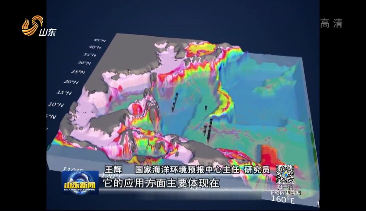
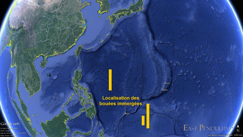
As for the exact location of these Chinese buoy systems, a local television station that interviewed some experts at the seminar in Qingdao showed a map broadcast by the NMEFC.

In particular, there is a "line" of buoys installed after the exit of Bashi Strait, located between the island of Taiwan and the Philippines, followed by two others south of Guam on the second chain of islands.
2017-06-23-Un-r%C3%A9seau-chinois-de-bou%C3%A9es-immerg%C3%A9es-01-1024x576.jpg

Please, Log in or Register to view URLs content!

On June 19th in Qingdao, a
Please, Log in or Register to view URLs content!
, where experts from several entities of the Chinese Academy of Sciences - (IOA), the National Marine Environment Prediction Center (NMEFC), and the Institute of Atmospheric Physics (IAP), for example, reviewed the results Called the buoy system and defined the next steps of the program.

After almost three years of construction, China has deposited some 20 buoyed submerged buoy systems in the western Pacific Ocean to collect data on temperature, salinity, speed and direction of ocean circulation, and l Intensity of echo in the water, between 400 and 4000 meters deep.

Please, Log in or Register to view URLs content!

Please, Log in or Register to view URLs content!


Please, Log in or Register to view URLs content!

Data collected by submerged buoys
Please, Log in or Register to view URLs content!


Since the end of 2016, two old systems, which were able to transmit data only once a year using manual recovery, have been upgraded with wired and wireless floating relays, thus enabling all hours of data to be transmitted From buoys to Chinese satellites, which relay them with ground stations.
 
Last edited:

Hendrik_2000

Lieutenant General
(cont)
It is now 192 consecutive days, until Monday, June 19, that the new systems are working and transmitting information to the ground.


Please, Log in or Register to view URLs content!

The floating buoy serving as a relay with the satellites

Please, Log in or Register to view URLs content!

Installation of submerged buoys with instruments


"Before, the nearest submerged buoys were 400 meters deep, the data could not reach the satellites," said WANG Fan, QDIO's deputy director, "We will now be able to improve our climate prediction models And oceanic thanks to these real-time data. "

"Here are the data from 8:10 this morning, which is coming from our satellites," chief scientist Wang Jia Ning turns on his mobile phone and shows the results to reporters, "These are data on ocean circulation per layer of eight Meter, recorded an hour ago in the western Pacific, from sea level up to 1,000 meters deep. "

Officially, this program of submerged buoys for real-time transmission aims to improve the accuracy of weather and ocean forecasting models - IPA and NMEFC have received software that allows them to share and exploit this data Pacific - but there is no doubt that in-depth knowledge of this part of the world, where the Chinese submarines launch their nuclear deterrent patrols and the US attack submarines are trying to push them back, will increase the survivability and The success rate of these first thanks to the much more accurate submarine maps.


Please, Log in or Register to view URLs content!


Please, Log in or Register to view URLs content!


As for the exact location of these Chinese buoy systems, a local television station that interviewed some experts at the seminar in Qingdao showed a map broadcast by the NMEFC.

In particular, there is a "line" of buoys installed after the exit of Bashi Strait, located between the island of Taiwan and the Philippines, followed by two others south of Guam on the second chain of islands.


To be continued.

Henri K.
 
Last edited:

Iron Man

Major
Registered Member
Please, Log in or Register to view URLs content!


As for the exact location of these Chinese buoy systems, a local television station that interviewed some experts at the seminar in Qingdao showed a map broadcast by the NMEFC.

In particular, there is a "line" of buoys installed after the exit of Bashi Strait, located between the island of Taiwan and the Philippines, followed by two others south of Guam on the second chain of islands.
It doesn't make any sense to put an underwater monitoring system out in the second island chain. Any information obtained is not actionable since ASW aircraft certainly aren't going to be patrolling out that far, not to mention that sensors located out in the open like this will simply get destroyed during wartime. Not only that, these sensors definitely impinge on the EEZs of several Pacific Island nations. Imagine the Chinese reaction if the US put some sensors right off of Hainan's EEZ.

World EEZ Map.jpg
 

Iron Man

Major
Registered Member
How do you know that this isn't the Chinese reaction to US placing sensors along the Chinese coast already?

With the US, it is always prudent to assume that they were the aggressors first. As history shows.
I don't know, but outside of any evidence, I will assume they have not. Since you are the one suggesting this, go ahead and providence some evidence for your claim. Statements about what is and is not "prudent" to assume in your personal opinion don't count.
 

Yodello

Junior Member
Registered Member
I don't know, but outside of any evidence, I will assume they have not. Since you are the one suggesting this, go ahead and providence some evidence for your claim. Statements about what is and is not "prudent" to assume in your personal opinion don't count.


It doesn't make any sense to put an underwater monitoring system out in the second island chain. Any information obtained is not actionable since ASW aircraft certainly aren't going to be patrolling out that far, not to mention that sensors located out in the open like this will simply get destroyed during wartime. Not only that, these sensors definitely impinge on the EEZs of several Pacific Island nations. Imagine the Chinese reaction if the US put some sensors right off of Hainan's EEZ.

View attachment 39682

Well, since U.S is the number one aggressor and warmonger on Earth, it is in China's best interest to
place those sensors anywhere it deems necessary in order to maintain some vigilance against the US.
Remember, the U.S shot down a Syrian plane inside Syria 'self-defence'... what sheer hypocrisy. The US uses 'international rule of law' according to its wishes, China needn't listen to these Western hypocrites.China should use every means available to her to defend herself, and keep building her arsenal.
 
Top