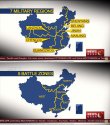
If you go by potential flashpoints or contingencies the multi-color map on the left makes more sense. In that map the Southern zone will face all of SouthEast Asia rather than splitting that "front" between two zones based on land versus sea borders. Anyways I am still not convinced we have seen the real map yet.
Given all the different maps we've seen in the past 2months, I suspect there has been a lot of internal debate and negotiation, but with this map, it looks pretty settled.
Yunnan in Southern Command makes sense because Vietnam is the primary land AND naval contingency, whilst Yunnan adds very little to Western Command.
The Philippines is a walkover and the US is simply not interested enough in the SCS.


