For westerners, Mt. Qomolangma is also known as Mt. Everest.
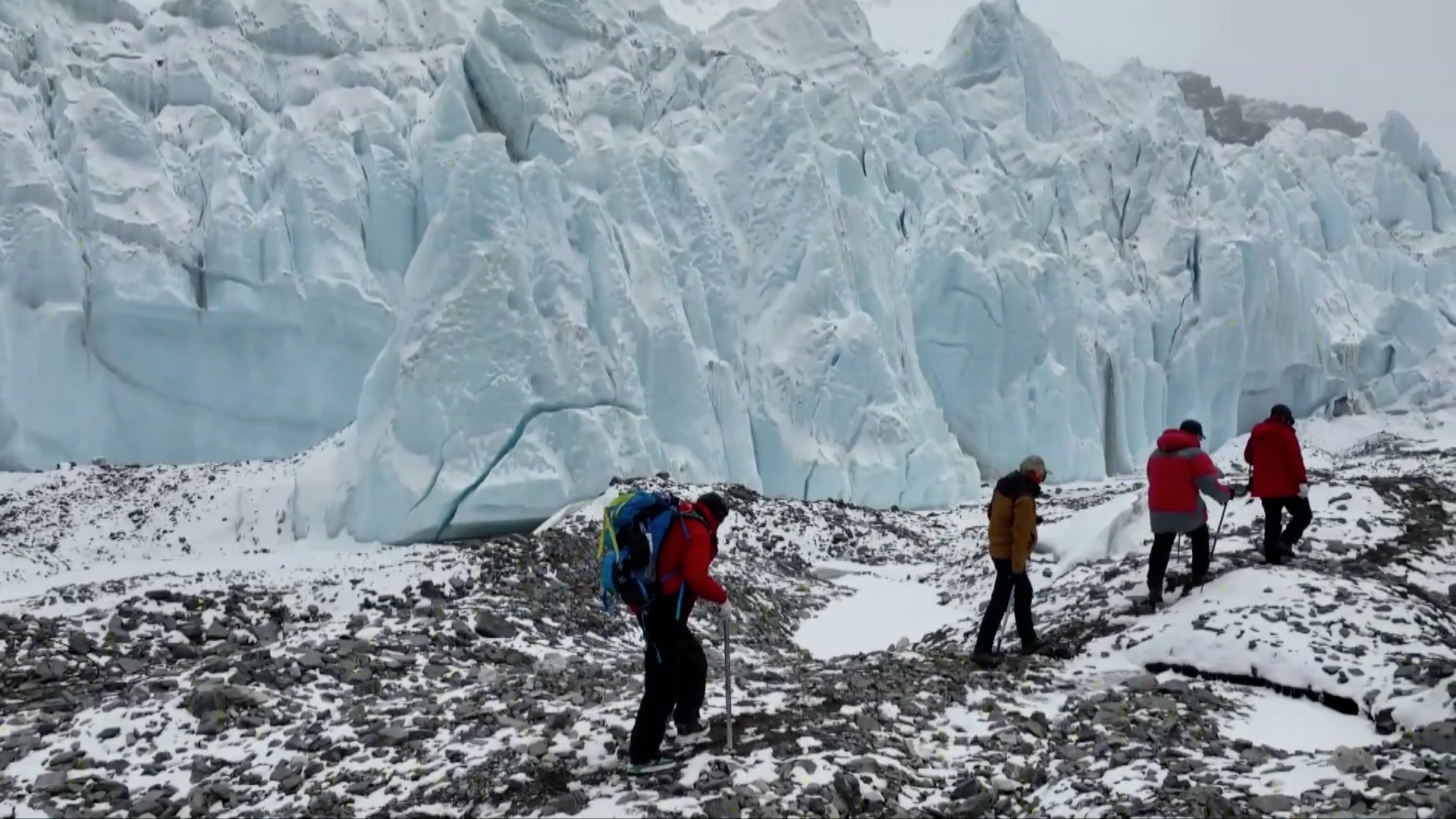
An expedition team from China set up a meteorological monitoring station on Mount Qomolangma at an altitude of 8,830 meters above sea level on Wednesday and tested it successfully for data transmission.
It is the highest automatic weather station in the world.
Powered by solar panels, the station is designed to last for two years under harsh weather conditions and is equipped with a satellite communications system for data transmission every 12 minutes.
Earlier this year, three meteorological stations were established on the north side of the mountain at 7,028 meters, 7,790 meters and 8,300 meters to take the number of operational weather stations between 5,200 meters and 8,300 meters to seven.
With the highest now fully installed, the eight stations will work together to record temperatures, relative humidity, wind speeds, wind direction, solar radiation and other data on the northern slope of Mount Qomolangma.
Installations under extreme conditions
Five surveyors of the expedition team were first to arrive at 8,830 meters to set up the meteorological station at around 12: 30 p.m., a couple of hours later than planned.
The weather on Mount Qomolangma is known to be elusive, and they had only a one-hour window to finish the installation before harsher conditions kicked in.
"Once the wind gets too strong, it will be very dangerous. Our hands and feet would be susceptible to frostbite," the team's lead mountaineer Dechen Ngodrup told CGTN in an interview from the base camp.
Earlier Wednesday morning, a peak climbing team member was experiencing frostbite in his hands and was resting at the camp at 8,300 meters but caught up with the team later.
Most of the peak climbing team are trained climbers.
It is the fifth time Ngodrup has stood atop Mount Qomolangma. He is considered a first-generation mountaineer and plateau scientist, holds a master's degree and is a doctoral candidate at the China University of Geosciences.
"It's an adventure. With every climb we prepare and we plan, we are simply exploring the scientific possibility of the future," he said.

You are using an out of date browser. It may not display this or other websites correctly.
You should upgrade or use an alternative browser.
You should upgrade or use an alternative browser.
News on China's scientific and technological development.
- Thread starter Quickie
- Start date
The hi-def camera has been delivered to the maker of the Qilu-2 satellite. The camera can do wide scanning at 0.7m image resolution in the visible spectrum. It also has highly sensitive infrared imaging capability at 14m resolution.
近日,随着产品运输车辆缓缓驶离虹口园区,上海技物所承担研制的齐鲁二号高分辨率光学相机顺利交付总体单位。作为中科院先导培育项目“构建与在轨验证天基资源网络化服务体系”系列小卫星之一——齐鲁二号卫星的核心载荷,该相机具有可见光大幅宽0.7米多光谱成像和热红外14米高灵敏度成像等功能,可实现对地高分辨率全天时敏捷成像及高清视频观测等重要应用。
研制过程中,科研团队突破了可见光多光谱大幅宽无缝拼接、热红外高灵敏度凝视成像、高分辨率可见红外一体化系统等关键技术,相机总体技术水平处于国内领先。
齐鲁卫星是山东首次发射自己的高分辨率商业遥感卫星,也是国内首次采用“天基互联网+遥感小卫星”模式的创新型遥感应用项目。


Qilu-1 and Qilu-4 were sent to orbits on April 27, 2021. According to this Chinese news, it was planned to launch Qilu-2 and Qilu-3 by end of 2021, then Qilu-5 and Qilu-6 in early 2022. So they have been delayed for some reason, it seems.
齐鲁一号卫星具有全天时全天候观测能力,可用于夜间和不良天气条件下遥感观测;
齐鲁二号卫星分辨率高、观测灵活且具有热红外谱段,可用于目标细节和工作状态探测;
齐鲁三号卫星观测幅宽大,可用于海洋观测、目标引导性观测和目标大范围搜索;
齐鲁四号卫星工作模式多,兼具拍照和视频模式,可用于固定场景持续凝视和动态监测。
据了解,“齐鲁二号”和“齐鲁三号”于 2021 年底发射;“齐鲁五号”和“齐鲁六号”于 2022 年初发射。未来3到5年齐鲁星座将发射20多颗卫星。通过激光互联,组网运行,对世界任意任任何一个地方,可实现全球任意地点一个小时内重访。省域月度全覆盖。
Check out the videos embedded in the article.
Swarm of micro flying robots in the wild
by researchers of Zhejiang University. DJI might have taken notes of their contact info.
Aerial robots are widely deployed, but highly cluttered environments such as dense forests remain inaccessible to drones and even more so to swarms of drones. In these scenarios, previously unknown surroundings and narrow corridors combined with requirements of swarm coordination can create challenges. To enable swarm navigation in the wild, we develop miniature but fully autonomous drones with a trajectory planner that can function in a timely and accurate manner based on limited information from onboard sensors. The planning problem satisfies various task requirements including flight efficiency, obstacle avoidance, and inter-robot collision avoidance, dynamical feasibility, swarm coordination, and so on, thus realizing an extensible planner. Furthermore, the proposed planner deforms trajectory shapes and adjusts time allocation synchronously based on spatial-temporal joint optimization. A high-quality trajectory thus can be obtained after exhaustively exploiting the solution space within only a few milliseconds, even in the most constrained environment. The planner is finally integrated into the developed palm-sized swarm platform with onboard perception, localization, and control. Benchmark comparisons validate the superior performance of the planner in trajectory quality and computing time. Various real-world field experiments demonstrate the extensibility of our system. Our approach evolves aerial robotics in three aspects: capability of cluttered environment navigation, extensibility to diverse task requirements, and coordination as a swarm without external facilities.
I believe we have seen some videos made by the same team a while ago, posted in the UAV thread.
Hendrik_2000
Lieutenant General
This is just amazing via broadsword any one can think of military application for this new algorithm aside from providing infantry with recce in jungle environment
May 4, 2022
A new system of flying while avoiding obstacles enables a swarm of 10 lightweight drones to fly together without crashing into one another – or the environment. Drones can compute their location and find a path to follow using a panoply of sensors, which can be expensive and unwieldy. Shrinking down a drone often involves getting rid of key components, impacting its ability to travel safely. But a new method by Chinese researchers reduces the size and hardware requirements of a drone while keeping its computing nous. Learn more ➤
Drone swarm avoids crashing in dense forest using new algorithm
34,053 viewsMay 4, 2022
A new system of flying while avoiding obstacles enables a swarm of 10 lightweight drones to fly together without crashing into one another – or the environment. Drones can compute their location and find a path to follow using a panoply of sensors, which can be expensive and unwieldy. Shrinking down a drone often involves getting rid of key components, impacting its ability to travel safely. But a new method by Chinese researchers reduces the size and hardware requirements of a drone while keeping its computing nous. Learn more ➤
Man must be a horrifying moment when soldiers hear those drone buzzz sound coming from a distant you know your fucked.
I’m sure there will be plenty of opportunity for soldiers to surrender to drones, the game is up once you are detected. Mass murder is not needed.Man must be a horrifying moment when soldiers hear those drone buzzz sound coming from a distant you know your fucked.
近日,中国科学技术大学潘建伟、张强等与济南量子技术研究院王向斌、刘洋等合作,实现了一套融合量子密钥分发和光纤振动传感的实验系统,在完成光纤双场量子密钥分发(TF-QKD)的同时,实现了658公里远距离光纤传感,定位精度达到1公里,大幅突破了传统光纤振动传感技术距离难以超过100公里的限制。
光纤振动传感以光纤作为传感器进行振动感知,通过利用单根光纤同时实现振动监测和信号传输,由于具有灵敏度高、响应快、结构简单、分布均匀等优点,在结构健康监测、油气管道泄漏监测、周界防护和地震监测等工程领域具有广泛的应用前景,因此引起了人们的广泛关注和研究。当前,光纤振动传感多使用分布式声波传感技术,其传感距离被限制在100公里以内,面临的一个重要技术挑战是如何克服距离限制,实现远距离的光纤振动传感。
Seismic Sensing Using Quantum Cryptography Network
An experiment demonstrates that quantum key distribution networks, which are part of highly secure cryptography schemes, can also detect and locate earthquakes.
One form of quantum cryptography involves an optical fiber network over which users share encryption keys—strings of bits used to encode and decode messages. Fiber networks can also be used to sense earthquakes, and now researchers have shown that the two tasks could be combined []. The team sent a quantum key distribution (QKD) signal over a 658-km-long fiber while causing the fiber to vibrate at a specific location. They detected this vibration via the optical signal and showed that they could determine its position to within 1 km. The new technique could potentially piggyback on QKD networks currently being set up in China, South Korea, and other countries.
In 2020, researchers at Google used regular undersea fibre optic cables to detect earthquakes. It appears that they were not able to pinpoint the locations though:
The “red vs. expert” debate has long preoccupied observers of Chinese elite politics. Ever since Deng Xiaoping, the presence of so-called “technocrats” in Chinese Communist Party (CCP) leadership has leavened Party politics with considerable pragmatism. That’s because Deng, like the leaders who succeeded him, believed that nation-building required domain expertise and technical chops, not just pure-bred CCP politicians.
Thanks for this article man because it reinforce my firm belief and support for Pres.Xi’s vision and leadership of the country. The fact that his administration has tapped the highly educated experts as part of the government more than "political ideology" says about his leadership and which also dispels the ridiculous accusations that he's being surrounded by simpletons from the Karen's and Ken's of the western politburo.The “red vs. expert” debate has long preoccupied observers of Chinese elite politics. Ever since Deng Xiaoping, the presence of so-called “technocrats” in Chinese Communist Party (CCP) leadership has leavened Party politics with considerable pragmatism. That’s because Deng, like the leaders who succeeded him, believed that nation-building required domain expertise and technical chops, not just pure-bred CCP politicians.