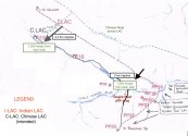
PPs 17 - 17a are near the CK confluence. 17a is Gogra post. PPs 18-20 are near Kongka LA, an entirely different region. Look on google maps, there is an Indian road from hot springs post(marked on Gogra) towards those points near Kongka La. No reputable Indian media or government source has reported problems there.
BTW Shukla incorrectly marked Hot Springs as Gogra. H wasn't the only person to do that, but if he is a retired soldier with so much knowledge of the area, he should know better. His drawing is also vague, and doesn't even include the Changlung, which is important since CK region is the only area where PLA has a camp within India's perception. He also is claiming that India has a different perception of the LAC than China in the entire Hot Springs Sector, which contradicts Lt. Gen. Panag's accounts. The only area where India and China have differing perceptions is the CK region, which is the current standoff point(the problem area, as you refer).. Abhijit Iyer clearly showed this in his map of the LAC, which is corroborated by Detresfa, Nathan Ruser, and the US Office of the Geographer.
Detresfa has already shown that China's kongka La post is well outside India's perception, though it does have smaller camps and roads closer to the LAC. If you disagree, please show any reputable Indian
media source or government statement that specifically mentions any point past 17a, or even better, some satellite evidence.
As for the PPs, I have already shown them
Pp16
PP 15
pp17A is Gogra, at CK (The problem area)
The remaining pps are along the Kongka La bulge. No issues have been reported there., so I don't know why you are so obsessed with them.

