Ladakh Flash Point

Status
Not open for further replies.

manqiangrexue

Brigadier
It's easy to see who's more angry and stinging from the outcome here from India's COVID overload:

India: Need oxygen; help! People dying; hospitals overwhelmed.

China: Sure, we'll send you oxygen.

India: Screw you; keep your dirty crap. USA, Australia, anyone! HELP, need oxygen; people dying!

Rest of World: Our thoughts and prayers go out to you... but our oxygen stays here.

China: Your people are lying on the streets outside hospitals; you need this oxygen.

India: ........................................................ Pfffff, fine. Gimme the stupid oxygen...
 

steel21

Junior Member
Registered Member
Perceived LAC is the official term used by the Indian government. India's official claims are the entirety of Aksai Chin, While China officially does not recognize Ladakh as a part of India. India's perceived LAC for the most part corresponds to where China reached in 1962, but there are some differences in perception by both sides. Once again, this is the official terminology. In areas like Galwan and Hot Springs, China's perception is west of India's, and in areas like Demchok and Pangong, India's is East of the current LAC. I

Where did India have to withdraw? In Galwan and Pangong, India withdrew from forward areas it had never occupied before. In Pangong, India had never held any position east of Finger 4, and Finger 4 effectively blocked off indian troops patrolling on foot. India only forward deployed some temporary camps near finger 4, other than that India is exactly where it was before the standoff started. China meanwhile had created permanent and strategic infrastructure all the way up to its perceived lac but had to dismantle it all and withdraw to shere it started. So status quo ante restored.

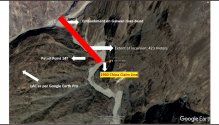
In Galwan China's perceived lac is roughly halfway within the Indian controlled portion of the valley, and its claims are even further. During the disengagement, both sides withdrew from the Indian perception of the lac, meaning China is even further back from its lac than it was before Previously India only patrolled the valley when conditions permitted, now it has permanent camps and strategic infrastructure connecting the valley to DBO all the way to the beginning of the buffer zone, which is also China's perception. This is clearly visible on google Earth. In addition, India occupied the heights adjacent to the valley, securing that portion of DBO. So how did India withdraw when in both secotors, China withdrew more? And how did the LAC change? The fact is China tried to shift the LAC westward but failed.

The noly active conflict point of the last standoff is in Hot springs, where China did come pretty close to its perception, which is roughly the confluence of the Kugrang and the Changlung. Previously, Indian patrols never went past pp15 which i roughly located around the confluence, however last summer India forward deployed beyond pp15 into China's perceived lac. During last July's disengagement, China withdrew most of its camps, and now only one Indian and one PLA camp remain in the disputed area, which lies within both the Indian and Chinese perceptions. Once again, the Indian camp is far beyond where Indian soldiers used to patrol. That standoff is still ongoing.

It would be helpful to do basic research on the subject.

For reference, this is a CIA map of the LAC as it was in the early 2000s. That line stills stands today, despite china's attempts to shift it west, even though both sides still have their perceptions/claims. There is the LAC as it stands(de facto) and the LAC both sides perceive/claim. Neither of those have changed.
TLDR: What is your point? Those desolate shitholes are only a pride issue because the Indians perceive it to be. Hey, maybe there are some vaccine and oxygen deposit buried there.

Perceived? Who's perception is it anyway?
 

twineedle

Junior Member
Registered Member
In Galwan, LAC has remained the same for decades. If anything, it has shifted east since 1962. Both sides disengaged from the historic Indian claim line, meaning China is farther from its claim than before 2020. The LAC has remained the same for decades, and hasn't shifted despite China's attempts, despite what some indian media/political activists are saying.
In Depsang, China is roughly 10 km from its perception/claim.
In Hot Springs, China is several km from its claim line, the confluence of the kugrang and Changlung. Anyone can see that the only PLA camp left is more than a few meters from its claim line/perception, as shown by the yellow line. India has a camp far beyond its historic limits of patrol(pp15) and only about 2 km from its perception.) PPs are typically located 1-3 km from India's perception of the lac.
In Gogra, there is no PLA presence inside India's perception, even though some Indian media claim that without evidence. Satellite imagery clearly shows the conflict point is limited to Hot Springs/Kugrang Valley. Even Lt. Gen. H.S. Panag agrees that there is no incursion there, and that there is no difference of perception at gogra.

Overall result, with the exception of hot springs, where the standoff is ongoing, and India has a camp well beyond its historic patrolling limits deep within China's claims in response to China's violation, the LAC is the same place where it has been for decades, as shown by the below CIA map. This is despite China's attempts to shift it towards its historic claim lines.

And for those who don't understand, there is the LAC that exists on the ground(de facto) and the Indian perception. India's perception is only different from the de facto lac at Pangong, Demchok, and Depsang. Neither the LAC nor India's perceptions have shifted.
 

Attachments

  • kashmir_region_2004.jpg
    kashmir_region_2004.jpg
    397.7 KB · Views: 7
  • IMAGE-2.png
    IMAGE-2.png
    756.5 KB · Views: 2
  • Like
Reactions: Div

Xizor

Captain
Registered Member
In Galwan, LAC has remained the same for decades. If anything, it has shifted east since 1962. Both sides disengaged from the historic Indian claim line, meaning China is farther from its claim than before 2020. The LAC has remained the same for decades, and hasn't shifted despite China's attempts, despite what some indian media/political activists are saying.
In Depsang, China is roughly 10 km from its perception/claim.
In Hot Springs, China is several km from its claim line, the confluence of the kugrang and Changlung. Anyone can see that the only PLA camp left is more than a few meters from its claim line/perception, as shown by the yellow line. India has a camp far beyond its historic limits of patrol(pp15) and only about 2 km from its perception.) PPs are typically located 1-3 km from India's perception of the lac.
In Gogra, there is no PLA presence inside India's perception, even though some Indian media claim that without evidence. Satellite imagery clearly shows the conflict point is limited to Hot Springs/Kugrang Valley. Even Lt. Gen. H.S. Panag agrees that there is no incursion there, and that there is no difference of perception at gogra.

Overall result, with the exception of hot springs, where the standoff is ongoing, and India has a camp well beyond its historic patrolling limits deep within China's claims in response to China's violation, the LAC is the same place where it has been for decades, as shown by the below CIA map. This is despite China's attempts to shift it towards its historic claim lines.

And for those who don't understand, there is the LAC that exists on the ground(de facto) and the Indian perception. India's perception is only different from the de facto lac at Pangong, Demchok, and Depsang. Neither the LAC nor India's perceptions have shifted.
Saying "LAC has remained the same for decades" over and over doesn't make it true.
There is no LAC without India's perception. No real LAC and perceived as such. LAC = line of Actual Control.

For the rest, I shall indulge -
Coming to where India had to step back.

Galwan - LAC of India shifted back by 1 km. Buffer zone created with new LAC. China laid a road to near the bend. China now claims most of Galwan.

Depsang - LAC of India broke down. China has camps quite far into Depsang. No point of LAC here, China is an odd kilometer away from her supposed Claim.

Hot Springs - PP15, as was discussed before, China's camp exists a kilometer into India's LAC. China is meters away from its Claim lines.

Gogra - beyond PP17A. Indian LAC not clear. But judging from Indian news itself, China is 700m into the LAC of India. (The issue here being the location of patrol points).

Result : China moved closer to its claim lines (except in Pangong Tso which is down south).
Depsang-
Please, Log in or Register to view URLs content!

Galwan-
Please, Log in or Register to view URLs content!

Gogra -
Please, Log in or Register to view URLs content!


Finally,

India still pushes for further disengagement while China was reported to have replies with "India should be happy with what has been achieved".
 

Bellum_Romanum

Brigadier
Registered Member
There is one PLA camp in India's perception of the LAC,and an Indian camp mirror deployed within China's perception. Both are in the disputed area neither side patrolled before until last year.


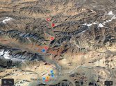
The above image was a timelapse showing how the specific conflict point(Kugrang Valley) east of pp15 changed between last June and April, which is the only conflict point in the area. I have already posted two zoomed out and annotated maps(Abhijit Iyer's and Detresfa's).
Not here to discuss the ladakh situation but if am to assume that you're Indian who lives in India, I just want to say to be safe and protect yourself and your loved ones from the scourge of Covid-19 that's currently rampaging in your country writ large. I hope you're not going to take my sincere wish of good intentions in a wrong way.
 

twineedle

Junior Member
Registered Member
Reposting since it is relevant, with an additional image.
The Lac has not shifted west since 1962. The proof is right here.
Please, Log in or Register to view URLs content!
Since no clear, UNBIASED, NEAUTRAL evidence has effectively countered the line google has used for decades, that is the lac that stands, I posted it above for those interested in facts, not preconceived notions. That map is corroborated by historic Inidan documents and even declassifed CIA Maps, including one of the first documents to map the LAC. If anything, the LAC has shifted East, meaning India has gained territory since 1962.
View attachment 70693

SImilarly, no changes in Gogra-Hot Springs
The CIA and Google maps are corroborated by historical Indian documents and claims, which show India's perception of the LAC has always been where it is on those maps for decades. The LAC that exists today is the same that existed for decades. Even Lt. Gen. H.S. Panag, an anti- Modi general who served in that area of Ladakh including the Valley, agrees that the Indian perception of the LAC is in line with the Google Maps.
Since no clear, unbiased evidence has been presented that India's perception of the LAC of the LAC has changed, the CIA and google maps stand. All other claims are politicaly motivated heresay.

The ground reality is China attempted to shift the LAC to match its own claims/perceptions but failed.

AS for Gogra Hot Springs, both the LAC and differing perceptions are quite clearly marked. India's perception in red, China's in yellow.
the current conflict point in Hot Springs is within the bulge, where India has a camp several km into China's perception and only an odd kilometer away from its own perception. This is well beyond pp15, India's historic patrolling boundary. In Gogra there is no difference in perception, and no evidence of any incursion, just more unsubstantiated claims.
 

Attachments

  • kashmir_region_2004.jpg
    kashmir_region_2004.jpg
    397.7 KB · Views: 6
  • IMAGE-2.png
    IMAGE-2.png
    756.5 KB · Views: 11

Xizor

Captain
Registered Member
Reposting since it is relevant, with an additional image.

The CIA and Google maps are corroborated by historical Indian documents and claims, which show India's perception of the LAC has always been where it is on those maps for decades. The LAC that exists today is the same that existed for decades. Even Lt. Gen. H.S. Panag, an anti- Modi general who served in that area of Ladakh including the Valley, agrees that the Indian perception of the LAC is in line with the Google Maps.
Since no clear, unbiased evidence has been presented that India's perception of the LAC of the LAC has changed, the CIA and google maps stand. All other claims are politicaly motivated heresay.

The ground reality is China attempted to shift the LAC to match its own claims/perceptions but failed.

AS for Gogra Hot Springs, both the LAC and differing perceptions are quite clearly marked. India's perception in red, China's in yellow.
the current conflict point in Hot Springs is within the bulge, where India has a camp several km into China's perception and only an odd kilometer away from its own perception. This is well beyond pp15, India's historic patrolling boundary. In Gogra there is no difference in perception, and no evidence of any incursion, just more unsubstantiated claims.
The first one in particular doesn't provide any idea about the LAC in the region.

Just because you repeat it, won't make it true.
India's LAC has never been officially released by Indian Government.

As for the second map - it is clearly drawn without any details like Patrol Points and lack of a good brief explaining. We have discussed it over and over.


Yet, why do you post these maps that is far from relevance. We are discussing the precise LAC of the region and how India has never managed to enforce it and how China has pushed back India getting closer to its Claim line?

I'm attaching all the maps for the four regions discussed over months here -
Galwan -
Annotation 2021-03-20 230504__01.jpg

Screenshot_20210322-225754.jpg
Hot Springs
Annotation 2021-03-19 094402.jpg

Gogra(Patrol Points as given by an retired Indian soldier and not rebutted)
Screenshot_20210302-060634__01__01__01.jpg
Depsang -
Please, Log in or Register to view URLs content!
 

twineedle

Junior Member
Registered Member
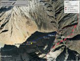
Google Earth has updated to show that India's most forward camp is about 1.4 km from pp14, well within China's perception, while even according to the Shukla claim line PLA is not within India's perception. China is farther from its claim line than it was before. And still no clear UNBIASED, NEUTRAL evidence has been provided that the lac at Galwan today is not the LAC that has existed for decades. The LAC existing about half a km south of the bend is India's perception, China's perception is roughly 2.5 km into India's portion of the valley.
The first one in particular doesn't provide any idea about the LAC in the region.

Just because you repeat it, won't make it true.
India's LAC has never been officially released by Indian Government.

As for the second map - it is clearly drawn without any details like Patrol Points and lack of a good brief explaining. We have discussed it over and over.


Yet, why do you post these maps that is far from relevance. We are discussing the precise LAC of the region and how India has never managed to enforce it and how China has pushed back India getting closer to its Claim line?

I'm attaching all the maps for the four regions discussed over months here -
Galwan -
View attachment 71350

View attachment 71351
Hot Springs
View attachment 71352

Gogra(Patrol Points as given by an retired Indian soldier and not rebutted)
View attachment 71353
Depsang -
Please, Log in or Register to view URLs content!
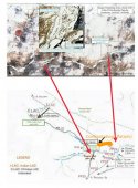
Once again you are making the mistake of trying to match Shukla's drawing with detresfa's clear map. Shukla doesn't even show the Changlung river, making it hard to ascertain his perception of pp15. And according to Shukla's map, Gogra post should be several km east very close to the black line, which is actually well within the Chinese side of the LAC.
 

twineedle

Junior Member
Registered Member
Once again, the LAC at Gogra-hot Springs is clear. Indian perception of the LAC is in Red, Chinese perception in Yellow. The conflict point has always been within the yellow bulge, well beyond pp15

India's historic perception of the LAC at Galwan is also quite clear. Once again, no clear and unbiased evidence has been presented otherwise, just politcally motivated heresay.
Please, Log in or Register to view URLs content!
 

Attachments

  • IMAGE-2.png
    IMAGE-2.png
    756.5 KB · Views: 10

Xizor

Captain
Registered Member
Google Earth has updated to show that India's most forward camp is about 1.4 km from pp14, well within China's perception, while even according to the Shukla claim line PLA is not within India's perception. China is farther from its claim line than it was before. And still no clear UNBIASED, NEUTRAL evidence has been provided that the lac at Galwan today is not the LAC that has existed for decades. The LAC existing about half a km south of the bend is India's perception, China's perception is roughly 2.5 km into India's portion of the valley.

Once again you are making the mistake of trying to match Shukla's drawing with detresfa's clear map. Shukla doesn't even show the Changlung river, making it hard to ascertain his perception of pp15. And according to Shukla's map, Gogra post should be several km east very close to the black line, which is actually well within the Chinese side of the LAC.
Bold 1: China's perception of Claim line.
Don't be ambiguous. Not LAC. Claim line. And this is as per Disengagement.

Bold 2: China has expanded its Claim line to all of Galwan. It more or less satisfied its Claim line there.

Bold 3: True. Good that you agree. India's perception of LAC existed south of the bend and with the current disengagement it was changed to the bend, effectively pushing back India.

Bold 4: No mistakes here. We both had a session where you tried to fit the map your way and failed. Read up Ajai Shukla's detailed writing ( I have posted the link).

Bold 5: Map not to scale. Shukla's depiction gives approximate locations. There is only an "Intended LAC" of China and not true LAC.

Read up the map legends and study it before writing.
 
Status
Not open for further replies.
Top