China's Space Program Thread II

gpt

Junior Member
Registered Member
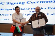
On the morning of July 12, 2024, Professor Fay Schippengen, Chairman of the Hungarian Heliophysics Foundation, led a delegation to visit the headquarters of the Deep Space Exploration Laboratory in Hefei.

Wu Yanhua, chief designer of major projects for deep space exploration, and Hu Chaobin, secretary of the Party Committee and deputy director of the Deep Space Exploration Laboratory, met with Chairman Fay Hippenbogen and his party.

Chief designer Wu Yanhua extended a warm welcome to Chairman Fay Hippenbogen and his entourage, and introduced the relevant situation of the Deep Space Exploration Laboratory and the progress of major deep space exploration missions.

Chairman Fay Schibenbergen expressed appreciation for China's achievements in the field of deep space exploration and introduced in detail the basic situation, international cooperation and future plans of the Hungarian Heliophysics Foundation.

The two sides said they would strengthen cooperation in the field of deep space exploration. After the meeting, the two sides signed the Memorandum of Understanding on Cooperation of the International Lunar Research Station (ILRS).
Please, Log in or Register to view URLs content!


Hungary ILRS.jpg
 

escobar

Brigadier
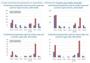
Charts showing the cumulative mass of spacecraft launched in orbit (and the related spacecraft value/capex estimates) in two periods, 2014-2018 and 2019-2023 limited to institutional programs & excluding the large mass/values of human space programs.
The mass & value are organised by customer region, so we can see the relative effort each space power is actually putting into their civil space program, vs their military space program. And it is quite obvious that military programs are leading the growth. When considering China we can all but notice how it is now aiming to be the most important global space power, on the basis of government funded programs. And this is not even considering human flights, but only focusing on civil and military satellite applications.
GS3FsAzWEAEF2N-.jpg
 
Last edited:

by78

General
High-resolution images from the launch of Gaofen-11-05 remote sensing satellite, which was carried out by a Long March 4B. This marks the 528th flight of the Long March series.

53868874695_2cd4f6d524_h.jpg
53868875870_13f8740cc7_k.jpg

53868460176_e07279d142_k.jpg
53868812974_e9c4140365_k.jpg
53868460206_9bbf409508_h.jpg
 

by78

General
Excerpts from an academic paper outlining a concept development plan for lunar mining and resource utilization.

Short-term development goal (2020 to 2035):
– Form a lunar resource utilization strategic development plan and carry out preliminary technical research.
– Carry out technical verifications for in-situ lunar ice mining, hydrogen-oxygen conversion, oxygen production, and other technologies.

Medium-term development goal (2035 and 2045):
– Build "1 main station + X sub-stations" distributed scientific research station complex on the Moon.
– Implement independent resource utilization and inter-station resource coordination experiments at each (sub) station.
– Complete technical verification of lunar resource utilization technologies and processes.

Long-term development goal (2045 and beyond):
– China will lead the world in lunar resource utilization, and large-scale applications will be carried out in the three main fields of energy acquisition and utilization, mineral mining and refining, and lunar infrastructure construction, operation, and maintenance.
– Achieve significant economic returns from certain lunar resource utilization activities.
– The moon becomes a major outpost for deep space exploration; begin the construction of a Mars scientific research station and the expansion of Mars resource utilization activities.

53868708118_7be07fb3ff_o.jpg
53867554472_4278ff2380_h.jpg

53868459996_57e2956514_h.jpg

53868460016_bafb864e78_h.jpg
 

by78

General
Two images taken 27 years apart. Twenty seven years ago today, China's first geostationary meteorological satellite Fengyun-2A obtained its first image of Earth. Exactly 27 years later, Fenyun-4B took another image of Earth at the same position (2nd image).

53873641381_8cc8572f28_k.jpg

53873641441_b89a708ea4_k.jpg
 
Top