It is probably not 128, but I guess the number is still technically open to debate.are we sure it is really 128?
You are using an out of date browser. It may not display this or other websites correctly.
You should upgrade or use an alternative browser.
You should upgrade or use an alternative browser.
055 DDG Large Destroyer Thread
- Thread starter FarkTypeSoldier
- Start date
- Status
- Not open for further replies.
are we sure it is really 128?
No, it is still yet to be determined.
I think the dimensions they list are a bit off as well. I think the beam of the ship is closer to 20m, while the length of the ship is closer to 180m. of course that drawing is also assuming the side arrays are L band arrays, which we definitely do not know.
overall, it's a nice drawing but it's making a few assumptions about things that have yet to be determined
Nobody in this world (or at least this forum) can give a reasonably precise estimate of length and beam of the 055 at this time, so saying it's more likely 20 x 180 and that 21 x 176 is "off", is a pretty bold statement to make.No, it is still yet to be determined.
I think the dimensions they list are a bit off as well. I think the beam of the ship is closer to 20m, while the length of the ship is closer to 180m. of course that drawing is also assuming the side arrays are L band arrays, which we definitely do not know.
overall, it's a nice drawing but it's making a few assumptions about things that have yet to be determined
Nobody in this world (or at least this forum) can give a reasonably precise estimate of length and beam of the 055 at this time, so saying it's more likely 20 x 180 and that 21 x 176 is "off", is a pretty bold statement to make.
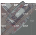
We've had satellite images showing the full length of 055 before, alongside 052Ds. By counting pixels or even measuring it on the screen, and by using the measurement of 052D's known length on GE using previous pictures, I think it is possible to attain a respectable estimate of 055's dimensions, particularly in terms of its length.

I remember you making those estimates, and remember at the same time that you don't necessarily know where to drop the end markers given that degree of resolution. You could easily be off by meters depending on where in your own personal opinion you have judged a shadow to end and a deck edge to begin. So really, you don't have any more access to accurate estimates than anyone else here.We've had satellite images showing the full length of 055 before, alongside 052Ds. By counting pixels or even measuring it on the screen, and by using the measurement of 052D's known length on GE using previous pictures, I think it is possible to attain a respectable estimate of 055's dimensions, particularly in terms of its length.
View attachment 40654
I remember you making those estimates, and remember at the same time that you don't necessarily know where to drop the end markers given that degree of resolution. You could easily be off by meters depending on where in your own personal opinion you have judged a shadow to end and a deck edge to begin. So really, you don't have any more access to accurate estimates than anyone else here.
There will of course be a measurement error, due to that degree of resolution, and also based on how clear the object we're trying to measure is based on the satellite's angle to the surface of the object.
That's why I have less confidence in my beam estimate than my length estimate.
And at least I'm able to put out a methodology to defend, and a common picture that everyone else can try to measure as well if they want to.
Still, I'm not saying I have a more accurate estimate than anyone else here. However I do think I have a more accurate estimate for the length than the creator of that image did.
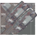
With, and without markers, roughly aligned next to each other. The orthogonal aft and bow lines obviously are not perfectly at right angles to the ship's aft and bow, but they are there to serve as a marker for the midline length estimate.

Your length estimate is just as impacted by angle of incidence as your beam estimate. You have no idea how directly on top of the ship the satellite is. This is not a wash even if the 052D is at an identical angle because the heights off the ground of the 052D and 055 are not the same. Also, based on that resolution you could easily be off by 2-4 pixels based on how close the color of the bow is to the ground and a similar lack of sharply definable edge of the stern.There will of course be a measurement error, due to that degree of resolution, and also based on how clear the object we're trying to measure is based on the satellite's angle to the surface of the object.
That's why I have less confidence in my beam estimate than my length estimate.
And at least I'm able to put out a methodology to defend, and a common picture that everyone else can try to measure as well if they want to.
Still, I'm not saying I have a more accurate estimate than anyone else here. However I do think I have a more accurate estimate for the length than the creator of that image did.
With, and without markers, roughly aligned next to each other. The orthogonal aft and bow lines obviously are not perfectly at right angles to the ship's aft and bow, but they are there to serve as a marker for the midline length estimate.
View attachment 40655
kwaigonegin
Colonel
Because naval designers aren't as flippant about ship design as "let's just throw a few extra MW in there for gits and shiggles". More MW means more expense, more space, and more fuel. There are non-flippant, legitimate reasons for more power and we have been discussing them. Maybe a PLAN designer does intend on putting in a super duper Keurig machine in the 055 in the future that requires "a couple" MW. In which case that designer should be taken out the back and shot.
Unless we know the power consumption of literally every single piece of power drawing device and machinery onboard the 055 down to the lightbulb in the head, it would simply be impossible to know for sure.
Yes I agree that ship designs run very lean for the reason you mentioned but there is also future proofing as well. Again we dont know what we don't know, however all I'm saying is it is not out of the realm of possibility to assume it has or can have between 16-20 MW power generation.
Your length estimate is just as impacted by angle of incidence as your beam estimate. You have no idea how directly on top of the ship the satellite is. This is not a wash even if the 052D is at an identical angle because the heights off the ground of the 052D and 055 are not the same. Also, based on that resolution you could easily be off by 2-4 pixels based on how close the color of the bow is to the ground and a similar lack of sharply definable edge of the stern.
I think this will end in both of us agreeing that there is a measurement error but disagreeing as to how significant that measurement error is for the purposes of differentiating what is a reasonable margin of estimates and whether the one listed in the picture falls in that range.
Let me be clear, I am neither agreeing nor disagreeing with either the CGI's numbers or your numbers. My point is that at this time there is no reasonable basis for saying one estimate is better than another when we are talking about differences of only a few meters, especially in the context of crappy low resolution images being all that we have to go on.I think this will end in both of us agreeing that there is a measurement error but disagreeing as to how significant that measurement error is for the purposes of differentiating what is a reasonable margin of estimates and whether the one listed in the picture falls in that range.
- Status
- Not open for further replies.
