Side-by-side comparison of the waverider (left) and biconical (right) HGV variants of the DF-17 at nearly the same view angle. Posted by Hainan Homosexual Guy on Weibo.
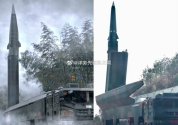



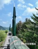

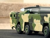

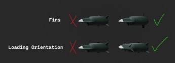
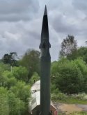

Bro just used my drawing.. Dammit I knew I should've put a watermark, I literally also had this epiphany myself a week ago.I've been so confused over the last few days due to the unusual orientation of the HGV tipped DF-17 until I saw Holehole's latest explanation:
View attachment 177644
What everyone was expecting thanks to 2019 parade
View attachment 177645
View attachment 177646
What was actually seen in the latest video
View attachment 177647
View attachment 177648
View attachment 177649
Holehole's explanation on how the TEL actually works
Note that both the mock up displayed in 2019 and the scale model he used above depicts the HGV with 3 fins, where as it turns out the real thing has four fins including one on the belly of the HGV. Here's a shot of it with the belly fin clearly displayed:
View attachment 177650
I suppose it's done so there isn't a fin that sticks straight down on the TEL to make the shape easier to handle, or alternatively no fin sticking straight up to make the enclosure around it taller than it needed to be. Not sure if there's any significance for foreign intelligence agency if they were also tricked for the last 7 years.
I was thinking in my mind that maybe the rocket sat on a turntable that could be rotated once it's vertical thanks to the 2019 display. Made zero sense since you'll just turn the whole TEL instead. Now the new mental model it makes sense.

Note that both the mock up displayed in 2019 and the scale model he used above depicts the HGV with 3 fins, where as it turns out the real thing has four fins including one on the belly of the HGV. Here's a shot of it with the belly fin clearly displayed:
I suppose it's done so there isn't a fin that sticks straight down on the TEL to make the shape easier to handle, or alternatively no fin sticking straight up to make the enclosure around it taller than it needed to be. Not sure if there's any significance for foreign intelligence agency if they were also tricked for the last 7 years.

You've misunderstood the technical principle of GPS signals in tactical missile launches. You don't need military-grade GPS signals to improve accuracy.There are clearly some misconceptions about GPS.
1) Back in 1996, civilian GPS signals were intentionally degraded through a program known as “”
Selective Availability (SA) was a GPS feature that intentionally degraded civilian positioning accuracy for national security. Its removal in 2000 greatly improved GPS performance for global users and reshaped navigation, safety, and commercial practices.
View attachment 177425
Therefore, GPS guidance could not be used without the ability to decrypt military GPS signals. I cautiously believe that, at least at that time, the PLA did not possess such capability.
2) At that time, GPS did not yet have the capability to block a specific area (this rumor also surfaced in connection with the Galaxy incident during the same period). The capability for satellite-based regional management was not realized until around 2000–2010 with the introduction of GPS III and OCX.

First of all, you’re deliberately confusing the two concepts. A moment ago, you were talking about GPS-guided technology, not GPS-assisted measuring—which is a completely different concept from GPS guidance.You've misunderstood the technical principle of GPS signals in tactical missile launches. You don't need military-grade GPS signals to improve accuracy.
What GPS actually measures is not the vehicle's precise position, but its velocity and position during the ascent phase. By using these signals to plot continuous spatial coordinate points, you can obtain a highly accurate ascent trajectory curve. GPS accuracy of 100 meters is far superior to the older method of radio command correction—placing two radio transmitters at specific angular offsets behind and to the side of the launch site, with the missile's onboard receiver measuring the difference between the two radio signals to determine whether it is flying along the pre-planned ballistic trajectory (this was the scheme used in the V-2 era). For the method China employed from the 1970s through the 1990s, the launch-phase navigation accuracy was definitely inferior to GPS. Even the deployment requirements for those two radio transmitters meant that a slight mistake could introduce errors far exceeding those of the GPS solution (100 m). The advantage of GPS is that the error is constant regardless of flight distance—whereas with radio, it is not. Moreover, GPS requires less equipment and makes mobile launch positions much more convenient.
And your claims about China's missile measurement technology in the 1990s are complete nonsense.Back then, people in Taiwan did not believe China had the capability for GPS-guided systems (during the 1996 Taiwan Strait exercises, the U.S. shut down regional GPS guidance, causing missile test failures).
I don’t know which tabloid you got your “evidence” from claiming that PLARF was still using WWII-style dual-transmitter radio correction in the 1990s. Doppler radar has been standard technology since the 1960s. China already had ballistic missiles with accuracy far superior to that of the V-2 long before GPS came into use, so please stop spouting nonsense.What GPS actually measures is not the vehicle's precise position, but its velocity and position during the ascent phase. By using these signals to plot continuous spatial coordinate points, you can obtain a highly accurate ascent trajectory curve. GPS accuracy of 100 meters is far superior to the older method of radio command correction—placing two radio transmitters at specific angular offsets behind and to the side of the launch site, with the missile's onboard receiver measuring the difference between the two radio signals to determine whether it is flying along the pre-planned ballistic trajectory (this was the scheme used in the V-2 era).
Regarding the role of GPS in the ascent phase, you can look up literature from the 1990s. Twenty years ago, a lot of what we knew about the guidance of Chinese Rocket Force missiles was told to us by the editor of Inertial Worldmagazine during private gatherings (200X).Don't get too mistaken about the timeline and cycles of Chinese radar technology breakthroughs.First of all, you’re deliberately confusing the two concepts. A moment ago, you were talking about GPS-guided technology, not GPS-assisted measuring—which is a completely different concept from GPS guidance.
And your claims about China's missile measurement technology in the 1990s are complete nonsense.
I don’t know which tabloid you got your “evidence” from claiming that PLARF was still using WWII-style dual-transmitter radio correction in the 1990s. Doppler radar has been standard technology since the 1960s. China already had ballistic missiles with accuracy far superior to that of the V-2 long before GPS came into use, so please stop spouting nonsense.
By the way, which tabloid did you read that the U.S. shut down GPS signals in the Taiwan Strait in 1996?
You're still deliberately misinterpreting the meaning of this term.Regarding the role of GPS in the ascent phase, you can look up literature from the 1990s. Twenty years ago, a lot of what we knew about the guidance of Chinese Rocket Force missiles was told to us by the editor of Inertial Worldmagazine during private gatherings (200X).Don't get too mistaken about the timeline and cycles of Chinese radar technology breakthroughs.
Back in the 1980s–90s, the radar technology of Chinese defense-industrial enterprises—whether ground-based or airborne—was extremely backward. Many advanced architectures[*] were only at the prototype stage. Back then, China's analog tech wasn't up to par, and digital tech was just beginning to spread. There was none of that "advanced tech" you imagine.
Most electronic technologies only entered service after 2000.
I haven't even told you yet about the production of advanced inertial navigation systems back then—the production of inertial guidance systems for long-range ICBMs, especially the calibration and testing issues, the output issues (also told to us by the Inertial Worldeditor). A lot of things were more backward than you think. And back then, missile programs had to control costs—there weren't any advanced components to speak of. How could you think a technology that the West popularized in the 1960s, China could already popularize in the 1980s–90s? Especially in the short-range tactical ballistic missile sector (these were all 1980s–early-90s Chinese tech—back then China couldn't even make CRT TV tubes or air conditioners properly. In the 80s, how many defense electronics factories switched to civilian production, even had factory directors defect to the West). Where would the money come from for new tech and new equipment? Just keeping the troops' combat readiness going was already something. Those years the military was even running commercial sidelines—you forgot?
As for China digesting the APG-66 radar from the F-16 (the J-8II program in the 1980s—tech docs were given in the 80s, and a physical radar in the early 90s), China's copy didn't reach maturity until the late 90s. Basically, the avionics on the J-10 prototypes are said to have been straight F-16 originals (that symbol-generator LCD and the HUD). So yeah, the late 20th century was indeed pretty bleak.



First, you need to be clear: we're talking about equipment used on launch vehicles and ICBMs. Is that the same as the tracking, telemetry and control (TT&C) used on short-range surface-to-surface missiles in the Taiwan Strait scenario?You're still deliberately misinterpreting the meaning of this term.
Is what you're talking about the same thing as what people commonly refer to as a GPS-guided missile?
Please clarify exactly what you heard at this private gathering. Is PLARF still using the dual-transmitter radio correction from ww2 era?
The V-2 has a CEP of 10–17 km at a range of 320 km, which corresponds to a deviation of roughly 3–5% . In contrast, the DF-3—which China deployed in the 1970s and exported to Saudi Arabia in 1988—has a range of 3,000 km and a CEP of 1.5–3 km, with a deviation not exceeding 0.1%. With a range 10 times that of the V-2, its accuracy has improved by an entire order of magnitude. Could this have been achieved using the supposed primitive correction technology from World War II that you mentioned? Or does the missile sold to Saudi Arabia actually have a CEP of 100 km?
In 1980, China conducted an ICBM test with a total range of 9,070 km. The target area was a 2x2 km² square region in the South Pacific, and the actual impact point was only 250 m from the center of the target. Based on the V-2’s accuracy, wouldn’t that target area have to be a 600x600 km² area? Please tell me, where was GPS back then??
View attachment 178076
This is the Yuanwang-1 tracking ship, responsible for tracking the warhead and the launch vehicle. Wasn’t the PLARF limited to dual-transmitter radio correction back then?
View attachment 178079
View attachment 178078
Tell me, according to this intelligence document declassified by the U.S., what is installed on the Yuanwang-1? Is it GPS or a World War II-era radio transmit? Wasn't this copy handed out at your private gathering?
No one denies that China’s BM and radar technology lagged behind that of the US and the Soviet Union at the time, but to say it was on par with Nazi Germany’s technological level—are you serious?
Do the difficulties you mentioned regarding China’s defense industry have anything to do with GPS? Are the F-16’s radar and ground-based tracking radar the same thing?
Why do you always write so much to dodge the issue when your errors have clearly been pointed out?
Let me ask again: What is your evidence for the claim that “the U.S. shut down GPS signals in the Taiwan Strait in 1996”?
Was that also a secret revealed at your private gathering??