PLAN SCS Bases/Islands/Vessels (Not a Strategy Page)

Zetageist

Junior Member
What length do this runway ?

Comparing to artist depiction of runway in the above picture and Taiping Island, the future runway on Fiery Cross can easily be at least 2800m+ long.

This image has the length and width of Fiery Cross: View attachment 10539

Very impressive, it looks like a gigantic super aircraft carrier.
 
Last edited:

Blitzo

Lieutenant General
Staff member
Super Moderator
Registered Member
An interesting development... I wonder if these vessels can be used later to serve as afloat staging areas for amphibious, mine sweeping, and humanitarian missions in future similar to USN's Mobile Landing Platforms.

There are some good photos of artist depictions through the link

Please, Log in or Register to view URLs content!


Shiptec China 2014: CSSRC showcases plans to build floating docks for Spratly Islands

Cornelius Weening, Dalian - IHS Jane's Defence Weekly
27 October 2014

China is developing floating docks to support its land reclamation projects in the Spratly Islands in the South China Sea, according to shipbuilding industry officials and information provided at the Shiptec China 2014 exhibition in Dalian.

Officials from the China Ship Scientific Research Center (CSSRC), a subsidiary of China Shipbuilding Industry Corporation (CSIC), told IHS Jane's that it is developing multifunctional floating docks for deployment on the Paracel and Spratly Islands.

Renderings of the docks were displayed at Shiptec China 2014.

The docks, which will be manufactured on the Chinese mainland and transported to the islands for final assembly, consist of a large rectangular platform and a bridge connecting the platform with an island.

China will first deploy the docks to the Paracel Islands for trials and testing. After this phase is complete, the docks will be deployed to the Spratly Islands, CSSRC officials said.

Two variants are under development. A base unit consists of a towed multifunctional platform and a bridge. CSSRC said the platform can support the following capabilities: docking for 1,000-tonne ships, maintenance and repair stations for fishing vessels, an electric-power plant, fresh-water storage and supply, desalination of seawater, rainwater collection, and general storage of equipment and supplies.

A second platform variant is based on a semisubmersible vessel that can move under its own power, but not over long distances. The platform can be used for light construction and maintenance of an island, such as heightening sandbanks or removing reefs. CSSRC lists its additional capabilities as temporary living quarters for construction crews, and waste water treatment. The bridge is strong enough to carry a 10-tonne truck.

COMMENT
The floating docks will provide China with the ability to build small settlements on remote islands relatively quickly. The docks carry the basics a settlement needs, and the second variant can expand and improve the reclaimed island. If the docks are deployed in large numbers China could populate large areas of the Paracel and Spratly Islands under its control, thereby strengthening its claims.

However, the docks depend completely on external fuel-supply, which limits their utility. To counter this CSSRC is developing new variants powered by wind energy, either by relatively small wind turbines placed on the platform itself or by larger semi-mobile turbines constructed in waters nearby.
 
Last edited:

Zetageist

Junior Member
I came across a South China Sea map posted by the New York Time:
Please, Log in or Register to view URLs content!


It showed the islands and reefs controlled by the claimant countries and 200nm EEZ lines from each coastal country. By crossing reference with other maps, I can see that Fiery Cross reef (the big red saucer shape), Thitu (Pagasa) Island and Itu Aba (Taiping) Island (right at the edge of Philippine EEZ) are all outside of everyone's EEZ ('High Sea') if not taken into account of what the claimant countries tried to claim.
 

Blitzo

Lieutenant General
Staff member
Super Moderator
Registered Member
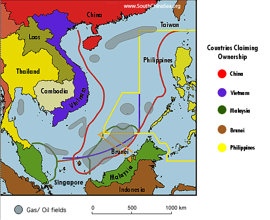
A rather deceptive map, as it doesn't show the claims of Vietnam or the Phillippines in full.

Overlapping-EEZ-Claims-and-Oil-Fields.png


I'd like to think they and other media outlets aren't doing this deliberately to make it seem like only China is making territorial claims (and thus making it stand out as "unreasonable"), and that the lack of clarification is only due to laziness, but either way, their portrayal of the stand off is eyebrow raising.
 

Zetageist

Junior Member
A rather deceptive map, as it doesn't show the claims of Vietnam or the Phillippines in full.

Overlapping-EEZ-Claims-and-Oil-Fields.png


I'd like to think they and other media outlets aren't doing this deliberately to make it seem like only China is making territorial claims (and thus making it stand out as "unreasonable"), and that the lack of clarification is only due to laziness, but either way, their portrayal of the stand off is eyebrow raising.

I agree with you. I just thought that NYT map is useful since it showed whether the important islands/reefs in Spratly Groups are within any country's main coastal EEZ.

BTW, the map you posted is not accurate as well because China did not claim Natuna Island (a rather big island (in tan color) at the bottom of SCS owned by Indonesia). Nine Dash Line does go near it however, so Indonesia is very nervous recently regarding China's vessels movement.
 

joshuatree

Captain
Another summary pic, main pic is Fiery Cross Reef (Yongshu Jiao). Additional locations identified (listing in order left to right, top to bottom)

West London Reef (Xi Jiao), Spratly Island (Nanwei Dao), Southwest Cay (Nanzi Dao), Namyit Island (Hongxiu Dao)

Woody Island (Yongxing Dao)

Hughes Reef (Dongmen Jiao), Gaven Reef (Nanxun Jiao), Cuarteron Reef (Huayang Jiao),
Johnson South Reef (Chigua Jiao), West York Island (Xiyue Dao)

Swallow Reef (Danwan Jiao), Taiping Island (Itu Aba), Pagasa Island (Zhongye Dao), Duncan Island (Chenhang Dao)

2r609w2.jpg


Amboyna Cay (Anbo Shazhou)

20rn5tc.jpg
 

Geographer

Junior Member
Thanks for those collages, joshuatree. Where are the creators getting the photos? I keep up with the latest photos to the best of my ability (checking Google image search and Google Earth frequently) but a few like the Woody Island photo with completed merged harbor are new to me.
 

shen

Senior Member
Please, Log in or Register to view URLs content!


Taiwan's live fire drill on Ba Binh (Itu Aba) Island of the Spratly Islands is a serious violation of Vietnam's territorial sovereignty, the Vietnamese foreign ministry said Monday.
Taiwan's move "threatened peace, stability, maritime security and safety, and further complicating the East Sea issue," the ministry spokesman Le Hai Binh said, using the Vietnamese name of the South China Sea.
The statement was made in response to reporters’ questions on Vietnam’s position on Taiwan’s notice of live firing from November 3-4.
Vietnam firmly opposes the act and demands that Taiwan immediately put an end to the illegitimate act and prevent similar occurrences, Binh said.
Vietnam has sufficient legal and historical evidence to prove its sovereignty over Hoang Sa (Paracel) and Truong Sa (Spratly) archipelagos, he stressed.
 
Top