You are using an out of date browser. It may not display this or other websites correctly.
You should upgrade or use an alternative browser.
You should upgrade or use an alternative browser.
PLAN SCS Bases/Islands/Vessels (Not a Strategy Page)
- Thread starter lilzz
- Start date
Blackstone
Brigadier
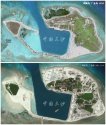
To be clear, are you saying the lower picture is how the situation is on November 19, 2015, and the upper picture is how the joined islands will look sometime in the future? It's a good and logical move, but how will Beijing explain the additional land expansions, when it already announced SCS artificial island constructions have ended?
The first picture (top) was dated March 17, 2015. The second (lower) is dated November 19, 2015.To be clear, are you saying the lower picture is how the situation is on November 19, 2015, and the upper picture is how the joined islands will look sometime in the future? It's a good and logical move, but how will Beijing explain the additional land expansions, when it already announced SCS artificial island constructions have ended?
They have already been doing this reclamation.
Blackstone
Brigadier
The top picture shows more land in the joint area than the bottom, and so I take it as a CGI for the eventual product.The first picture (top) was dated March 17, 2015. The second (lower) is dated November 19, 2015.
They have already been doing this reclamation.
Yes, the top one does have CGI showing what they wanted to get to, and the bottom shows where they are at as of November 19.The top picture shows more land in the joint area than the bottom, and so I take it as a CGI for the eventual product.
I guess my point was that both do show actual conditions (the non-CGI part of the top one), and it is a project that had already been started well before they announced they had stopped.
Perhaps what we see on the lower picture is all the "reclamation" that is planned now, and all they have to do is build up and improve the infrastructure.
Zetageist
Junior Member
... It's a good and logical move, but how will Beijing explain the additional land expansions, when it already announced SCS artificial island constructions have ended?
These are not artificial island constructions and are not located in disputed Spratly Islands, so the only one really is going to complain is Vietnam.
My take:-
China said it has stopped the reclamation in the Spratlys not the Paracels. Duncan and Palm are in the Paracels.
With all its excess capacity, it makes sense to use them for the work in the Paracels.
The pic dated March 17 was the situation of the islands as they were plus the plan addition in CGI.
The pic below dated Nov 19 is the latest situation. I noticed that Palm Island is already different from the CGI plan.
H
These first two pictures are of Duncan and Palm islands in December 2012:


This picture is earlier in 2015:

This picture is of Duncan and Palm Islands in November 2015:

They have definitely filled in the ponds on the upper side of the bigger island, filled in a lot to the right of the smaller island, and it looks like they have added land pretty much all around.
These pictures may help without having to deal with the CGI.The top picture shows more land in the joint area than the bottom, and so I take it as a CGI for the eventual product.
These first two pictures are of Duncan and Palm islands in December 2012:


This picture is earlier in 2015:

This picture is of Duncan and Palm Islands in November 2015:

They have definitely filled in the ponds on the upper side of the bigger island, filled in a lot to the right of the smaller island, and it looks like they have added land pretty much all around.


