PLAN SCS Bases/Islands/Vessels (Not a Strategy Page)

Sweeper Monk

New Member
Registered Member
I should clarify a bit more about the Philippines arguments and the aftermath

On Itu Aba is a rock not an island.

China has chosen an opt out clause in UNCLOS (article 298) which will mean it doesn't have to subject itself to arbitration on maritime boundaries with EEZs. The court also does not deal with sovereignty issues, which China feels this is.


So the Philippines counter argument is, well there is no need to determine maritime boundaries, because your holdings (even assuming they belong to you) can't generate an EEZ in the first place. So its not a sovereignty issue because even if you hold those islands, we get the majority of EEZs. Hur hur hur hur.

This is a tactic to give the court jurisdiction over the dispute by framing it not as a dispute over maritime boundaries, but an issue of denying a nation its EEZ. Johnny Cochcran would be proud.

Its obviously advantageous for those claimants in the SCS whose major territory is close to it, to deny the EEZs from the Spratly's, which kind of makes the point of claiming them in the first place useless from an economic point of view.

What will happen next
This is a bit of speculation on my part of course

Lets start with the case that Itu Aba is a rock fails. Under the rules it would become a maritime boundary dispute, and outside the Court’s purview. The Philippines have already stated they will then file a second suit to call for conciliation with China, which has less power. This would quite a victory for China, especially when they win without turning up.

Now lets give the opposite scenario. So Itu Aba is a rock. Options available to China are

a. Withdraw from UNCLOS

b. Wait for it to be taken up to the UN and veto it
c Comply to some extent

Option A. Well the US isn't a signatory of UNCLOS and it claims EEZs from territories which are uninhabited, quite a few islands actually. So certainly claiming EEZs are not being a member of UNCLOS is not unprecedented.

Option B.
The Article 94 of the UN charters states:

1) Each Member of the United Nations undertakes to comply with the decision of the International Court of Justice in any case to which it is a party.


2) If any party to a case fails to perform the obligations incumbent upon it under a judgment rendered by the Court, the other party may have recourse to the Security Council, which may, if it deems necessary, make recommendations or decide upon measures to be taken to give effect to the judgment.


So if China refuses to give in, the recourse is to take it to the security council where China will veto it. The US has exercised veto power in regards to Israel without embarrassment, so to can China.

Option C
If China complies, then all that’s left is using those bases as a shelter for fishermen or as a military base. This is unlikely to happen.
 

Lezt

Junior Member
The hexagonal structures on these new islands are 50% to 100% wider, and extend all the way up and do not taper. Much thicker. 10+ metres thick in most cases.


I am referring to the structures on the islands, not the seawalls that run around the boundaries of the islands.

10 metres across of rebar and concrete are far in excess of what is needed - even the lighthouses on these islands are far thinner and designed to withstand the same ocean forces.

These are being built to withstand entirely something else...
.

Well, it is a presumption that construction is designed to fulfill a specific need, that form follows function. LV and many others brands have shown us that is not the case.

The fact is, we are looking at this from the outside. it could be recessed weapon platforms, or a missile silo. but we don't know that. can it be a tsunami shelter? sure - as there is no sea wall 10 m tall around the island (yet).

So lets say they are weapon stations of silos, lets ask, what good do they do when they are exposed and is in the age of precision munition? a GBU28 or 37 will easily make mince meat of a 6+ m RC bunker.
 

nfgc

New Member
Registered Member
So lets say they are weapon stations of silos, lets ask, what good do they do when they are exposed and is in the age of precision munition? a GBU28 or 37 will easily make mince meat of a 6+ m RC bunker.

This is not a strategy thread, but a short answer....

Because China will view those islands as China, and attacking a silo on a 76,000 sq m sand bar will be interpreted by them as an attack on the mainland and insure a very disproportionate response from them, thus no one can use those precision munitions...
 

ahojunk

Senior Member
I stumbled on the following and it is an interesting read....
-----------------
Please, Log in or Register to view URLs content!

July 5, 2015 11:15 pm

I’m starting to think that the Chinese Communist Party has a secret agent at the highest levels of our government, the very highest in fact: President Benigno Cojuangco Aquino 3rd.

The only other explanation is that we have a President so dim-witted that he has cost not only us and future generations of Filipinos dearly, but has also changed the balance of power in Asia by unwittingly helping Chinese expansion into the disputed areas of the South China Sea.

He lost Panatag (Scarborough) Shoal to the Chinese in 2012, when he ordered our ships to leave it after a week-long standoff, believing the claims by his Foreign Secretary Albert del Rosario and his secret envoy, Senator Antonio Trillanes 4th, that the Chinese had agreed to a simultaneous withdrawal. They didn’t, of course.

That’s the second island we’ve lost after the Vietnamese grabbed Pugad Island in the Spratlys in 1975, when our forces left it to attend their commander’s birthday party on a nearby island. They returned the next day to find a Vietnamese garrison on it, telling them to go away.*

Aquino’s most recent strategic blunder, and bad not only us, but probably for the world, is his order for the government in January 2013 to file a case at the United Nations Permanent Arbitration Court asking it to rule that China is violating the provisions of the UN Convention on the Law of the Sea (UNCLOS) and that the seven reefs it is occupying belong to the Philippines.

It is this case that has given the Chinese both the justification and the urgency to convert their seven reefs in the Spratlys, which they seized in 1988 and 1995, into islands through massive reclamation work that started right after the suit was filed. (These are Fiery Cross, Cuarteron, Subi Reef, Gaven, Hughes, Johnson South, and Mischief reefs, all of which are between the islands we occupy and Palawan.)

Manilatimes.1.UNCLOS2015060706.gif
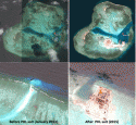
Images before and after the PH filing of its UNCLOS suit. Above Hugh Reef, below Cuarteron. (Images from Google Earth.)

It’s a misconception – probably deliberately disseminated – that our suit is asking for the court to rule as illegal China’s so-called “nine-dash line,” a vague tongue-shaped dashed line on its maps, which declares practically the entire South China Sea as theirs, including our Kalayaan Island Group.

While it did mention that such nine-dash line is “invalid,” the Philippine case involves the argument that the Chinese can’t occupy what are merely “rocks,” which the suit, invoking UNCLOS provisions, called “submerged reefs with no more than a few rocks protruding above sea level at high tide.”

Paragraph 24 of our “Statement of Claim” submitted to the Court says: Even as these Chinese-held “features are ‘rocks’ under Article 121(3) of UNCLOS, China unlawfully claims entitlements to maritime zones greater than 12 nautical miles in the waters and seabed surrounding them, and wrongfully excludes the Philippines and other States from these areas.”

“Rocks” are in contrast to islands, like our Pag-asa Island, which UNCLOS gives a 12-mile territorial zone and another 12-mile contiguous zone. Besides, Aquino’s government argued, the entire Spratly island also falls within our mainland’s 200-mile exclusive economic zone around it, in which the Chinese-controlled reefs are located.
China didn’t agree to be “arbitrated,” which makes one wonder how the case should be called, as an arbitration is defined as two parties’ agreement to let a third party settle their dispute.

The Chinese, however, exploited the issue raised by the Philippines, and in effect replied to our claim that they’re just sitting on rocks, and therefore should leave:
“So they’re just rocks, huh? Wait and we will make them into islands.”

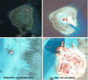
A few months after we filed the case in early 2013, the Chinese went on a reclamation frenzy on the seven reefs, which previously only had bunkers on stilts planted on the reefs.
Above Gaven Reef, below Johnson.

An analogy – a very rough one, though – would be if in a land placed under a homestead law, you had a concrete fence built around your property. You then file a case in court asking it to declare that only lands surrounded by a fence can be titled for private ownership. What do you think would other settlers rush to do?

US got scared

The US a few months ago got scared that the reclaimed area could accommodate military installations, including airstrips for military aircraft. It made public its high-definition spy-satellite photos – cleverly through a private news website (diplomat.com) – on the Chinese reclamation work.

The world woke up to find that the seven reefs on which the Chinese previously had bunkhouses on stilts, had become islands with ports, buildings, and even airstrips.

Manilatimes.2.UNCLOS2015060706.gif
The reclamation blitz at Gaven (above) and Johnson Reefs, before and after the Philippine suit. (Images from Google Earth.)

Of course, we could argue that the UNCLOS provision had that descriptive phrase “naturally occurring” islands. Still though, our case now risks being thrown out entirely on factual grounds.

Our suit repeats again and again that the Chinese are merely occupying “rocks” below the sea, so they are within our exclusive economic zone. But China has changed the very geographic features of the seven areas they had occupied, turning them into islands.

Now the Court, and even the UN itself, may have to ask its signatories to define if an island is an island if it was created out of reclamation work. It would certainly seem awkward to classify that such lands as Kansai International Airport, Hong Kong International Airport, the Palm Islands of Dubai or even our Mall of Asia – all artificial islands – are just “rocks.”

Before our suit was filed in 2013, China occupied only seven reefs, with a land area of zero.
In contrast, we have occupied seven islands with a total area of 84 hectares, less Pugad Island, which we lost in 1975. Our “flagship’ Pag-asa Island of 37 hectares, is the second biggest in the neighborhood, next to Taiwan’s Taiping island of 46 hectares. Our Likas Island is the third largest, with 19 hectares.

The islands with the Philippine flags were those that Marcos asked marines to occupy in the 1970s. We officially declared our sovereignty over those islands, as well as everything in those areas, when Marcos issued Presidential Decree No. 1596 of 1978, which drew a hexagon covering 29,000 hectares over what was internationally called the Spratly islands. The decree called it the Kalayaan Island Group, and declared it a municipality of Palawan province.

(The decree justified our claim to it: “WHEREAS, these areas do not legally belong to any state or nation but, by reason of history, indispensable need, and effective occupation and control established in accordance with international law, such areas must now be deemed to belong and subject to the sovereignty of the Philippines; WHEREAS, while other states have laid claims to some of these areas, their claims have lapsed by abandonment and can not prevail over that of the Philippines on legal, historical, and equitable grounds.)

Biggest landowner before

The biggest landowner as late as 2013 had been Vietnam, which has six islands with a total area of 47 hectares. Our loss to Vietnam of our Pugad Island in 1975 was such a colossal blunder, as it was the sixth largest island in the group.

After we taunted them that what they occupied were just “rocks,” the Chinese, through their unprecedented reclamation work, created islands out of the reefs, with an estimated total area of 598 hectares at present. Now they’re the biggest landowners in the neighborhood, thanks to Aquino.

Of course, one could argue that with or without our suit, China would have undertaken the massive reclamation work that created islands out of those reefs, that it was their ultimate goal right after they built bunkers on stilts on the reefs in the 1990s.

Yet, it is just too coincidental that right after our suit was filed, the reclamation blitz started. At the very least, Aquino gave them the justification, and the urgency to build the artificial islands.

No matter how much I try, I can’t remove that image in my mind of leaders in Southeast Asia pulling their hair in exasperation: “Why do the Filipinos have such a stupid President?”
While the Scarborough “standoff” lasted nearly two weeks in 2012 and the filing of the UNCLOS case came two years later, Aquino did not even convene the National Security Council for their inputs on these matters of such grave importance to the Republic.

In fact, nobody knows if Aquino consulted anyone on these matters, and if he did, who was it? Senator Trillanes 4th, who had bragged to me that he had contacts that go as high as the Politburo?

I never imagined a President could do so much harm not only on a country but on the region.
 
Last edited:

Lezt

Junior Member
Sooo why do u need a bunker? You put a blow up doll there and if anyone throw a spitball at it, the effect is the same.

Would China be OK if a dumb bomb hit the island vs a gub37?

You don't need a strengthened structure for your hypothesis
This is not a strategy thread, but a short answer....

Because China will view those islands as China, and attacking a silo on a 76,000 sq m sand bar will be interpreted by them as an attack on the mainland and insure a very disproportionate response from them, thus no one can use those precision munitions...
 

no_name

Colonel
I stumbled on the following and it is an interesting read....
-----------------
Please, Log in or Register to view URLs content!

July 5, 2015 11:15 pm

I’m starting to think that the Chinese Communist Party has a secret agent at the highest levels of our government, the very highest in fact: President Benigno Cojuangco Aquino 3rd.

That's another running joke among Chinese military-political watching netizens. Not only Aquino, but also Abe and dear old Obama are Chinese secret agents. Obama, he's the deep sea here.
 

nfgc

New Member
Registered Member
Sooo why do u need a bunker? You put a blow up doll there and if anyone throw a spitball at it, the effect is the same.

Would China be OK if a dumb bomb hit the island vs a gub37?

You don't need a strengthened structure for your hypothesis

The structure would survive anything tossed at it by VN PH BN IN and MY.

10 metres thick of concrete? That far exceeds the most extreme structures built for similar purposes.

A dumb bomb lands, does minimal damage to the 10 metres of reinforced rebar and concrete, and the strategic value remains.

These structures are explicitly designed to withstand a regional clash over the islands, but are specifically not designed to withstand the US or JP navy.
 

nfgc

New Member
Registered Member
That's another running joke among Chinese military-political watching netizens. Not only Aquino, but also Abe and dear old Obama are Chinese secret agents. Obama, he's the deep sea here.

Nah, the Chinese Communist Party just think he is a bad President.
 

ahojunk

Senior Member
Picture of Thitu (Pag-asa) Island held by the Philippines. It has civilians and soldiers stationed here. Excluding the Chinese Islands, Thitu Island is the second biggest island in the Spratlys after Taiping Island.
Thitu.中业岛.Zhongye.2015-07-04_rappler_islandview.jpg
The airstrip is 1.4 km.
 

plawolf

Lieutenant General
Considering the case supposed to start like next month with a verdict not in until next year, I will take that claim of legally justified with a grain of salt.

Broadly speaking the Philippines will try two arguments, none of which relate to sovereignty per se as that is outside the courts jurisdiction. They will argue on the extent of EEZ under UNCLOS. These arguments are

1. China must define its claims on the 9DL so we can debate this.

This doesn't seem unreasonably, however China practices strategic ambiguity and any case that runs into issues is referred to the UNSC where China could just veto it.

2. Itu Aba is a "rock."

Please, Log in or Register to view URLs content!


Itu Aba is the largest natural island in the Spratly chain, and is garrisoned by the ROC (Taiwan) with population from sources saying 200-600. However since the US, Vietnam, and the Philippines all recognise the one China principle, it follows that they recognise anything owned by Taiwan is by extension China's. They can of course dispute ownership, although I like to the Philippines try to explain why they have ownership of an island they never cared about until 1978 when the ROC has garrisoned it since 1946, and continuously since the 1950s to this day. So they won't even argue ownership, they will argue EEZs.

Essentially rocks (structures above water at high tide but cannot sustain economic activity) cannot generate an EEZ but inhabited islands can. Islands of course are structures above high tide which can sustain economic activity and a population. So an uninhabited island behaves like a rock under UNCLOS. Rocks can only generate 12 nm territorial seas.

Now lets get the environmental angle out the way. While there are provisions that about environmental protection in UNCLOS but pretty much everyone has broke them. Plus people are protesting China's reclamations mainly on territorial or EEZ grounds, not on environmental grounds, and if environmental grounds were your best argument, maybe that implies your territorial arguments are bad.

Strictly speaking, you can reclaim on a rock you own. Like Japan did in Okinotorishima.

So structures which count as rocks (ie above water at high tide) include Scarborough shoal, Johnson reef , Cuarteron reef and Fiery Cross reef. So whoever owns these are within their rights to reclaim it. Of course ownership is disputed, but China's pretty much got these in the bag.


You cannot reclaim on a structure which is below water at high tide, unless you a) own it and b) if it falls within you EEZ.

The only way to claim a below water structure is if it falls within the 12 nm territorial sea generated by another one of your possessions which is above water at high tide. None of China's targets fall within this criteria. So lets go to option B.

Do any of the low tide elevations ie Mischief Reef, Kennan Reef ( Hughes reef) , Gaven Reef and Subi Reef fall within China's EEZ? The answer is, if China holds Itu Aba, then yes it does and its legal.

Article 56 of UNCLOS states that a nation can create an artificial island in its EEZ, although it will be subjected to environmental concerns (which every other state broke as well, but I digress). Mischief Reef is the furthest away from Itu Aba at around 74 - 75 nm. EEZs can be generated 200 nm.

Now you might ask, what about the Philippines own EEZ generated by Palawan? When two EEZs overlap, its negotiated between the states, but by convention we draw the line about halfway.The distance between Itu Aba and the Philippines is around 219 nm, so the halfway point is around 109.5 nm. So even Mischief Reef easily falls within that range.

When the Philippines own media refers to "rock" in inverted commas, you know something stinks about that argument. Essentially they will argue that the largest natural feature of the Spratly ISLANDS is really a rock and not an island.

A point of correction, whether an island is inhabited or not has no bearing on whether it can generated an EZZ, the key test is whether it can generate economic activity, and the key test for that is whether the island has its own standing water source IIRC.
 
Top