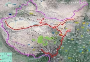
This was actually reported by Indian media a couple of years ago. It is the so-called Red Flag River project that was discussed among some forum enthusiasts on the China Internet and then picked up like it was official fact by Indian conspiracy theorists. Here is a map of that hypothetical project.The Chinese will have to seriously consider redistributing the increase in rainfall in the southern part of the country to the parched north western region. They can synchronize the pumping of dammed water in the southern region just before the rainy season to higher level reservoirs in the dry western region from where it can then flow by gravity to deserts or aquifers under the deserts. In this way the flood water can be saved and diverted to reclaim desert land for food crops.

Basically, it involves diverting a part of the river flow of several major rivers around the Tibetan Plateau upwards and northwards where it would flow by gravity through the Gansu corridor and onwards to the Western edge of Xinjiang with upwards of 60 billion cu/m of water annually. This would be enough to solve China's water problems in the southwest, northwest through to Gansu and Xinjiang. It would also replenish the Yellow River, irrigate Inner Mongolian desert north of Shaanxi, Shanxi and Hebei and replenish north China aquifers. It would literally solve almost all of China's water problems and create 200000 sq/km of arable land. However, this was just a hypothetical project and never received official sanction.


