8 minutes to help you open the "God's perspective"
At Wuhan University, Academician Li Deren's team showed the pictures and videos sent back by Luojia No. 3 01 Star to the reporter.
One of the video footage taken on April 16 shows that cars are driving on the Wuhan Yangtze River Bridge, and boats come and go on the Yangtze River. Guishan TV Tower, Yellow Crane Tower and Lianhua Lake Park on both sides of the Yangtze River are clearly visible.
In the image of Wuhan University taken on February 26, East Lake, Luojia Mountain, Zhuoer Gymnasium and other buildings are clearly visible. The distribution of buildings and school greening of Wuhan University is also very clear. This is the Star Lake Building where we are currently located. You see, the vehicles are still driving on the Optics Valley Bridge near the school. Academician Li Deren said.
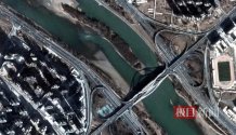 Video gaze imaging data
These dynamic images are all gaze video data. According to Academician Li Deren, a major feature of "Liojia No. 3 01 Star" is "multi-mode" - for the first time, it is equipped with a light and small remote sensing camera with a variety of imaging modes such as face array scanning, surface array push frame, video gaze, etc., breaking the existing single imaging mode, and providing a single image data and gaze video according to the different needs of users. Data, three-dimensional data and other types of observation data.
What is the function of staring at video data? Academician Lee Deulin continued to show the busy runway of Lotte World Tower and surrounding roads and Dubai Airport in Seoul, South Korea, photographed on February 21. In the video, static and moving cars and planes are tracked by red and yellow prompt boxes, respectively.
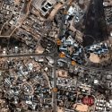
Vehicle target tracking results
"We submit the relevant information to the satellite, which can analyze and capture speeding cars in real time and track the operation of aircraft at the airport." Academician Li Deren said that the technology has analyzed the traffic flow monitoring in Karoka, Nigeria, and the static dynamic aircraft number monitoring at Kunming Airport. "If 200 to 300 satellites are launched in the future, it can be used for urban intelligent traffic management or the automatic management of airports."
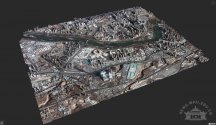
Lanzhou three-dimensional reality display
Providing three-dimensional data is also the "unusual skill" of the "luojia No. 3 01 star" staring video. Academician Li Deren showed a three-dimensional map of the real scene of Shigatse, Tibet, China, taken and produced on February 14. In the upper right corner of the picture is a continuous earthy yellow mountain, and at the foot of the mountain is a city. Each building is three-dimensional. If you don't distinguish it carefully, it will be regarded as an aerial photo.
According to reports, the "Ojia No. 3" 01 star has been in stable operation in orbit for three months, and has provided timely data services for disaster relief operations such as the assessment of the earthquake-stricken area in Syria in Turkey and the assessment of the collapse of the Alxa coal mine in Inner Mongolia.
Satellites experience the smartphone revolution
Eight minutes after the instruction is issued, the mobile phone can receive the video taken by the satellite. How does this work?
The reporter of Jimu News followed Professor Wang Mi, the technical master of "Ojia No. 3 01 Star", to the rooftop of the teaching experiment building of the Department of Information Technology of Wuhan University and saw a small satellite ground station.
Professor Wang Mi pointed to the satellite antenna and said, "We contacted 'luojia No. 3 01 Star' through it. At present, because there is only one experimental star, there is only a time window of 3-5 contacts a day. In the future, if there are more satellites, the satellites can pass through the 'top of the head' within 5 minutes for my use."
Zhao Quan, a doctoral student at the State Key Laboratory of Surveying, Mapping and Remote Sensing Information Engineering of Wuhan University, opened a software demonstration called "SpaceApp2" installed on his mobile phone. As long as the satellite observation location, observation time and imaging mode are selected, the task request will be pushed to the cloud service center. The cloud service center automatically generates task instructions and annotates instructions at Harbin Station through the ground measurement and control station network. When the satellite received the instruction, it began to perform the task. While collecting video, it carried out on-orbit intelligent processing, on-star compression, and transmitted the data back to the Wuhan ground station through the star-to-ground communication link. Subsequently, the big data center of Xinghu Building receives the data, analyzes it and forwards it to the mobile terminal. The whole process can be completed in 8 minutes.
Why can you respond so fast? Dr. Zhao Quan vividly described this as because compared with the traditional satellite, "luojia No. 3 01 star" is like a "smartphone revolution" upgrade.
"In the past, satellites were either powerful in 'taking photos', navigation, or for communication, and our satellites gathered these functions together, just like smartphones." Dr. Zhao Quan said that it can even upload and install a new "APP" to update the application function.
This is why Academician Li Deren proposed the integration of intelligent satellites many years ago. To this end, "Ojia No. 3 01 Star" has made technical breakthroughs in hardware and software.
For example, in the past, remote sensing data was transmitted back to the ground from the satellite for professional processing, and now it has achieved satellite in-orbit real-time processing technology. In the past, the transmission speed of the satellite-ground was slow, but now relies on the team's world-leading data compression technology, which greatly improves the transmission speed of the satellite-ground. At the same time, by opening up the satellite and The two-way link of the mobile phone realizes the minute-level intelligent service from remote sensing data to the mobile phone worldwide.
200 satellites form a wise eye constellation.
"I think I can give it a score of 95 points for the three-month on-the-rail test!" Academician Li Deren said that the series of achievements made by "Liojia No. 3 01 Star" will promote the leapfrog development of satellite remote sensing from traditional professional data services to popular, intelligent and real-time remote sensing information services.
Academician Li Deren said, "Of course, what a satellite can do is limited. We mainly use it for theoretical and application verification. In October 2022, Wuhan University and the Yantai Municipal People's Government signed a strategic cooperation agreement to jointly build the "Oriental Eye" constellation project. At present, the project has been officially launched, and it is planned to build a global service system from 2027 to 2030. At that time, 200 satellites are expected to be in orbit in the whole constellation.
According to reports, the composition of these 200 satellites, in addition to optical remote sensing satellites such as Luojia No. 3 01 Star, a certain number of radar satellites is also needed. Around May 15 this year, the radar satellite Luojia II 01 developed by the Wuhan University team will be launched from the Jiuquan Satellite Launch Center.
Academician Li Deren imagines that the "Oriental Eye" constellation project should achieve the goal of "fast, clear, accurate, complete and understand". In the future, almost everyone may have a satellite of the "Oriental Eye" constellation above their head. Ordinary people can use their mobile phones to "call" the satellite overhead within 3 to 5 minutes. You can see the pictures or video content you want to see.
Academician Li Deren said that the "Oriental Eye" constellation will serve the whole society at a very low price in the future, such as introducing ordinary members to citizens and gold members to professional users. In the old days, Wang Xietang Qianyan was about to "fly into the homes of ordinary people" to realize the transformation of the era from "playing WeChat" to "playing satellites" for the public.

