China's infrastructure projects and strategic implications

luminary

Senior Member
Registered Member
Now for the connections to Europe.

I will look into ports and maritime Silk Road next.
Please, Log in or Register to view URLs content!


If China wants a chance to really f**k with Turkiye and permanently rewrite European geopolitics, they should get started on this. A China-built Greece-Macedonia-Serbia canal (
Please, Log in or Register to view URLs content!
) would bypass the Turkish Straits and create a preferential water route for Chinese shipping.
The feasibility studies were done and it'd be a piece of cake for Chinese firms. It'd basically revitalize the economic outlook of the Western Balkans and create an entire pro-China bloc there (tbh Serbia and Greece are already friends). The canal cooperation could even help mend relations between North Macedonia and Greece (like what's happening with the Iran-Saudi talks).

Turkiye gets a lot of its power from being able to control the international commerce going through the Bosporus strait. They're planning on closing that strait and forcing traffic through their parallel and newly-built Istanbul Canal, where they'll toll cargo and control trade through the region. Having a Greece and China-provided, faster and cheaper route alternative would absolutely destroy their monopoly. Personally, Erdogan is a backstabbing a**hole and the sooner China gets him down on his knees the better.
 

luosifen

Senior Member
Registered Member

It is reported that the main transmission line of Chinese 1320MW Hubco coal power plant owned by '#China Power Hub Generation Company' in #Balochistan has been attacked & destroyed.The plant was recently synchronized with #Pakistan's National Power grid.
This twitter handle seems like an Indian run account, probably fake news considering the rest of the content it pushes.
 

TeaHSRn

Just Hatched
Registered Member
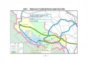
I came across this map on another forum and thought I should share it. I hope this is an ok spot for this.

The lines in red on the Map are railways to start construction by 2026 in Tibet. The far left red line is Hotan - Shigatse. The red dot is Lhasa, and the red line from Lhasa to the right is for the line to Nyingchin. The connecting blue line is the under-construction line to Chengdu, and the bottom right red line is Bomi to Shangri La.

Obviously having a rail line along the border areas, as well as extra connections to Tibet from Xinjiang and Yunnan are of huge strategic significance, especially when paired with the airstrips, heliports and roads all being built along the border areas. I also suspect that the Hotan - Shigatse line goes through Aksai Chin.

more information and maps in this thread -
Please, Log in or Register to view URLs content!


lhasa-railway-network-png.4571800
 

Taiban

Junior Member
Registered Member
I came across this map on another forum and thought I should share it. I hope this is an ok spot for this.

The lines in red on the Map are railways to start construction by 2026 in Tibet. The far left red line is Hotan - Shigatse. The red dot is Lhasa, and the red line from Lhasa to the right is for the line to Nyingchin. The connecting blue line is the under-construction line to Chengdu, and the bottom right red line is Bomi to Shangri La.

Obviously having a rail line along the border areas, as well as extra connections to Tibet from Xinjiang and Yunnan are of huge strategic significance, especially when paired with the airstrips, heliports and roads all being built along the border areas. I also suspect that the Hotan - Shigatse line goes through Aksai Chin.

more information and maps in this thread -
Please, Log in or Register to view URLs content!


lhasa-railway-network-png.4571800
Please, Log in or Register to view URLs content!

By 2025, the construction of several railway projects, including the Ya'an-Nyingchi section of the Sichuan-Tibet Railway, the Shigatse-Pakhuktso section of the Xinjiang-Tibet Railway and the Bomi-Ra'uk section of the Yunnan-Tibet Railway will all see major progress, according to the plan.

Other key projects also include the electrification of the existing Qinghai-Tibet railway and upgrading the double-track railways of the Pakhuktso-Hetian line of the Xinjiang-Tibet Railway and the Lhasa-Nyingchi Railway.
 

Taiban

Junior Member
Registered Member
I came across this map on another forum and thought I should share it. I hope this is an ok spot for this.

The lines in red on the Map are railways to start construction by 2026 in Tibet. The far left red line is Hotan - Shigatse. The red dot is Lhasa, and the red line from Lhasa to the right is for the line to Nyingchin. The connecting blue line is the under-construction line to Chengdu, and the bottom right red line is Bomi to Shangri La.

Obviously having a rail line along the border areas, as well as extra connections to Tibet from Xinjiang and Yunnan are of huge strategic significance, especially when paired with the airstrips, heliports and roads all being built along the border areas. I also suspect that the Hotan - Shigatse line goes through Aksai Chin.

more information and maps in this thread -
Please, Log in or Register to view URLs content!


lhasa-railway-network-png.4571800
9d760d2b404c4997b9865c5aea8fcabf_tplv-tt-large.jpeg
 

Taiban

Junior Member
Registered Member
Please, Log in or Register to view URLs content!

Railway from Shigatse to Hotan

The total length of this line is about 1,600 kilometers. It is planned to be divided into two sections, namely the section from Shigatse to Jilong County, and the section from Jilong County to Ngari District and Hotan. Among them, the section from Shigatse to Jilong County is about 460 kilometers long. It is planned to start from Shigatse City. It will be drawn from Shigatse Station in Sangzhu Pastoral Area and then connected to Lari Railway. It will drive westward and pass through Sakya County, Dingjie County, Dingri County and Nyalam. After Xiamude Village in the county, go to Pekucuo, Jilong County, and then turn southward until Jilong Port. Eight stations are planned for this section of the line, namely Shigatse Station, Sakya Station, Dingjie Station, Tingri Station, Xiamude Station, Pekutso Station, Jilong Station and Jilong Port Station.

The section from Geelong to Ali to Hotan is about 1,200 kilometers long. It is planned to start from Geelong County, then connect with the line from Shigatse to Geelong. It will be drawn from Pekutso Station and head northwest. After passing through Saga County and Zhongba County, enter Ngari. After passing Baga Township, Menshi Township, Kunsha Township and Gar County, turn slightly north and enter Ritu County, pass Bangong Lake and Duoma Township, and are expected to enter in the area of Quanshui Lake and Hongshan Lake In the Xinjiang Uygur Autonomous Region, it is expected to pass through Kashgar Tash Township, until Hotan City, and it is planned to connect to Hotan Station of the Southern Xinjiang Line. The line plans to set up six stations: Saga Station, Zhongba Station, Baga Station, Ali Station, Ritu Station and Hotan Station.
 

Taiban

Junior Member
Registered Member
I came across this map on another forum and thought I should share it. I hope this is an ok spot for this.

The lines in red on the Map are railways to start construction by 2026 in Tibet. The far left red line is Hotan - Shigatse. The red dot is Lhasa, and the red line from Lhasa to the right is for the line to Nyingchin. The connecting blue line is the under-construction line to Chengdu, and the bottom right red line is Bomi to Shangri La.

Obviously having a rail line along the border areas, as well as extra connections to Tibet from Xinjiang and Yunnan are of huge strategic significance, especially when paired with the airstrips, heliports and roads all being built along the border areas. I also suspect that the Hotan - Shigatse line goes through Aksai Chin.

more information and maps in this thread -
Please, Log in or Register to view URLs content!


lhasa-railway-network-png.4571800
TV5GMfI3VS1lgV_tplv-tt-large.jpeg
 
Top